"Farewell to Brill" two Brills [Brill trolley buses] westbound on 41st at Dunbar
- AM1533-S2-4-: 2009-005.265.1
- Item
- 1984
Part of Dunbar History Project fonds
Item filed under Transportation.
376 results directly related Exclude narrower terms
"Farewell to Brill" two Brills [Brill trolley buses] westbound on 41st at Dunbar
Part of Dunbar History Project fonds
Item filed under Transportation.
Part of Dunbar History Project fonds
Item filed under Transportation. Collection of Wally Young.
Part of Dunbar History Project fonds
Item filed under Transportation.
Part of Dunbar History Project fonds
Item filed under Transportation.
1949 Brill trolleybus #2174 southbound on Dunbar at 21st in snow
Part of Dunbar History Project fonds
Item filed under Transportation.
[Man with #7 Fraser streetcar]
Part of Dunbar History Project fonds
Item filed under Transportation.
Audrey Gowe and her mother, Flora in front of CPR station on Dominion Day, first car, 1925
Part of Dunbar History Project fonds
Item filed under Transportation. Note that the steering wheel is on the right.
Part of Dunbar History Project fonds
Item filed under Transportation.
Part of Dunbar History Project fonds
Item filed under Transportation.
Part of Dunbar History Project fonds
Item filed under Transportation. Courtesy of Margaret Moore.
Part of Dunbar History Project fonds
Item filed under Transportation.
Part of Dunbar History Project fonds
Item filed under Transportation.
Part of Dunbar History Project fonds
Item filed under Transportation.
Marine Drive in winter, Hillman car
Part of Dunbar History Project fonds
Item filed under Transportation.
Part of Dunbar History Project fonds
Item filed under Transportation. Courtesy B.C. Hydro information services.
Part of Dunbar History Project fonds
Item filed under Transportation.
Streetcar travelling North on Dunbar
Part of Dunbar History Project fonds
Item filed under Transportation.
![[Street cars and taxicabs on Hastings Street]](/uploads/r/null/e/3/e3460b082958ce0fb70de47b3e1459bdb3ce0a26a86c14d8c3200e76490c633e/2bb3fbd4-de88-4667-a78d-09fa1c22a6be-A09848_142.jpg)
[Street cars and taxicabs on Hastings Street]
Part of Major Matthews collection
![Big Outfit Starting for Klondike [in front of] Johnston, Kerfoot and Company - 104 and 106 Cordov...](/uploads/r/null/b/b/bb3cd07a1ba100cc07995e16864284758450d3649cc9b80550e9281be6b626bb/f179280f-7f6a-4dfd-8bd8-ab4ea97bda41-A37249_142.jpg)
Part of Major Matthews collection
Photograph shows a mule train and the Trorey (Birks) clock

Part of Major Matthews collection

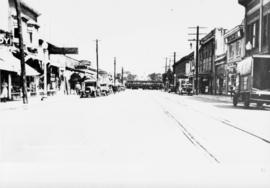
Dunbar and 41st, looking east on 41st
Part of Dunbar History Project fonds
Item filed under Transportation. Courtesy of Hodgson/Sharman Collection.

Marine Drive in winter, Hillman car
Part of Dunbar History Project fonds
Item filed under Transportation.

Audrey Gowe and her mother, Flora in front of CPR station on Dominion Day, first car, 1925
Part of Dunbar History Project fonds
Item filed under Transportation. Note that the steering wheel is on the right.

Part of Dunbar History Project fonds
Item filed under Transportation.

Part of Dunbar History Project fonds
Item filed under Transportation.

Part of Dunbar History Project fonds
Item filed under Transportation.

Part of Dunbar History Project fonds
Item filed under Transportation.

Part of Dunbar History Project fonds
Item filed under Transportation.

Part of Dunbar History Project fonds
Item filed under Transportation.

Streetcar travelling North on Dunbar
Part of Dunbar History Project fonds
Item filed under Transportation.

Part of Dunbar History Project fonds
Item filed under Transportation.
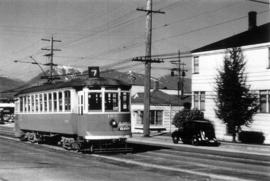
!["Farewell to Brill" two Brills [Brill trolley buses] westbound on 41st at Dunbar](/uploads/r/null/b/6/b64665374b5a976e4f90c2116caa5e28cf9e28585dfffd5faa9ed855070b7935/8694bcbf-2554-4cb6-83c0-2a5de6e85be7-A73259_142.jpg)
"Farewell to Brill" two Brills [Brill trolley buses] westbound on 41st at Dunbar
Part of Dunbar History Project fonds
Item filed under Transportation.

1949 Brill trolleybus #2174 southbound on Dunbar at 21st in snow
Part of Dunbar History Project fonds
Item filed under Transportation.
Part of Dunbar History Project fonds
Item filed under Transportation.

Part of Dunbar History Project fonds
Item filed under Transportation. Collection of Wally Young.

Part of Dunbar History Project fonds
Item filed under Transportation. Courtesy of Margaret Moore.

Part of Dunbar History Project fonds
Item filed under Transportation. Courtesy B.C. Hydro information services.
![[Man with #7 Fraser streetcar]](/uploads/r/null/c/6/c6805c8dc9b249de9fa07bf4470fd39e89444f6c6cb3bd658744f61a52d12d0d/213c3b30-4b46-489c-8108-cb9645decce5-A73265_142.jpg)
[Man with #7 Fraser streetcar]
Part of Dunbar History Project fonds
Item filed under Transportation.
West 41st Avenue looking east toward West Boulevard
Part of Dunbar History Project fonds
Item filed under Transportation. An interurban streetcar is visible in the background of the image.
West 41st Avenue looking east toward West Boulevard
Part of Dunbar History Project fonds
Item filed under Transportation. An interurban streetcar is visible in the background of the image.
City Magazine : summer/fall 1989 : vol. 11: no. 1
Includes article, "Planes, Trains and Automobiles: How New Transportation Schemes are Americanizing our Suburbs."
City Magazine : spring 1989 : vol. 10 : no. 4
Includes article, "A New Dawn for Planning" regarding the Forum for Planning Action.
False Creek heritage streetcar and transit centre development feasibility report
"In June of 1991, a conceptual proposal for the use of the False Creek Transit site was presented to the BC Transit Board of Directors and the Vancouver Regional Transit Commission. The Board of Directors. . . requested a study be initiated to determine the feasibility of operating a False Creek Heritage Streetcar system . . . ."
Dennis Cooney
False Creek heritage streetcar and transit centre development : appendix A : site planning report
"Long term transit planning for downtown Vancouver has indicated a need for a transit service around False Creek which can be better integrated with downtown and the metropolitan region. City of Vancouver policies are increasingly emphasizing the need for energy efficient land use and transportation initiatives. This report presents a vision that addresses these needs . . . ."
Baker McGarva Hart Ltd.
B.C. Electric Rly. Co. Ltd. plan showing transit services in Vancouver city as at end of 1951
Part of City of Vancouver Archives technical and cartographic drawing collection
Item is a transit map of Vancouver showing existing and proposed service routes under the three year transit modernization plan for years 1948-1951.
Item is a pamphlet showing a map of the city of Vancouver on one side with map index and advertisements on the other side.
Dial map of the city of Vancouver including the adjacent municipalities
Part of City of Vancouver Archives technical and cartographic drawing collection
Item is a street map showing Vancouver, Burnaby, New Westminster, West Vancouver and North Vancouver on one side and the University Endowment Lands, Surrey, Maillardville, Lulu Island and Sea Island on the other.
Sectional map and street directory of Vancouver : Dial map of the city of Vancouver
Part of City of Vancouver Archives technical and cartographic drawing collection
Item is a street map showing Vancouver on one side and Burnaby and New Westminster on the other, as well as information on street car and bus routes, and text advertising the products and services of the Dominion Map and Blueprint Company.

Street index (Gibson Street to William Street) and tram stations
Part of City of Vancouver Archives technical and cartographic drawing collection
Part is a page from the booklet accompanying a guide map of Greater Vancouver, and contains the last portion of the North Vancouver street index, the West Vancouver street index, and a list of Vancouver tram stations.