Series consists of heritage evaluation forms on buildings deleted from the heritage register because the building has been demolished. The request for a deletion originates from the applicant for a development permit where that redevelopment entails demolition of the existing building(s). Once the development permit is approved because there is no possibility of keeping the building through negotiation with the owner, demolition is permitted. Arranged by street address.
Item consists of a photograph depicting a model created by Planning Department staff to study view obstructions which result from various building configurations, based on different options to be included in zoning regulations for the West End.
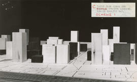
Item consists of a photograph depicting a model created by Planning Department staff to study view obstructions which result from various building configurations, based on different options to be included in zoning regulations for the West End.
Item consists of a photograph depicting a model created by Planning Department staff to study view obstructions which result from various building configurations, based on different options to be included in zoning regulations for the West End.
Item consists of a map depicting the locations of bus stops in the downtown area, with scaled lines that most likely depict volume of bus services during rush hour.
Series documents the core planning functions performed by the Planning Department, including land use and development planning, administering the Zoning and Development By-law and related by-laws, and providing advice on planning matters to other City units, Council and the Mayor's Office.
Records in this series consist of subject and project files relating to non-Heritage matters which were the responsibility of the Department. Subject titles corresponding to blocks in the departmental file plan have been retained as the first part of file titles.
Series consists of cronaflex stereoscapic aerial survey photographs used for data collection to support planning and engineering activities. The photographs were created by a variety of photographic firms, under contract for the Planning Department. The series includes index maps for many of the flights. Some years are incomplete.
Series consists of computer printouts of primarily business license, development permit and building permit data, relating to the preparation of analyses of building characteristics and business, development, and land use activities. Printouts used as source material for articles in the Quarterly Review (PDS 29) and for the Vancouver Coreplan. Arranged alphabetically by printout title.
Series consists of photographs created by the Planning Department to document the renovation and construction of Blood Alley Square, Trounce Alley, and Maple Tree Square.
Series consists of films or copies of films collected by the Planning Department, and related to the City and regional planning of the 1960s: urban renewal, downtown planning, and harbour development. Arranged chronologically. The films were presented by the City of Vancouver. Films were produced by Pageant Productions Ltd. of Vancouver for the National Film Board of Canada.
Series consists of building case files concerning permits to demolish heritage designated buildings typically containing heritage evaluation forms including photographs, as well as various reports, correspondence, news clippings, etc. Arranged alphabetically by address.
Series consists of photographs of building facades of the "character areas" of Vancouver taken for reference purposes to aid heritage and development planning processes. (A few months earlier the department had prepared its Goals and Objectives statement for 1974, which expressed the desire to broaden the local area planning activities to include beautification and heritage factors (PD 147)). The "character areas" were: "Financial", "Hastings", "Gastown", "Central Core" (east of Granville), "Robsonstrasse", and the "potential character area" of "Georgia Gate". Photographed by departmental Planning Assistant. Arranged alphabetically by street address.
Item is a copy of an Engineering Department map which has been annotated to show pre-1916 residential construction, existing major streets, public and semi-public buildings, single and two-family dwellings, multiple family dwellings, district commercial, industrial, open spaces, proposed additional major streets - 1976, proposed deletion of existing major streets - 1976, proposed freeways and secondary schools in the city of Vancouver.
Series contains a large accrual of photographs produced by and for the Planning Dept. which require further appraisal, series analysis, and description. Arranged chronologically.
File consists of datasets provided by Statistics Canada from the 2011 Census as a custom profile data order for the City of Vancouver, using the City's 22 local planning areas. Datasets contain demographic information by local area. File also contains Open Data Catalogue html pages that described the datasets; pages include data attributes and data accuracy and currency information. Datasets are as they appeared on May 20, 2014.
File consists of datasets containing information on properties or sites given heritage status or recognition. File also contains Open Data Catalogue html pages that described the datasets; pages include data attributes and data accuracy and currency information. Datasets are as they appeared on May 20, 2014.
File consists of datasets provided by Statistics Canada from the 2001 Census as a custom profile data order for the City of Vancouver, using the City's 22 local planning areas. Datasets contain demographic information by local area. File also contains Open Data Catalogue html pages that described the datasets; pages include data attributes and data accuracy and currency information. Datasets are as they appeared on October 22, 2014.
File consists of datasets provided by Statistics Canada from the 2001 Census as a custom profile data order for the City of Vancouver, using the City's 22 local planning areas. Datasets contain demographic information by local area. File also contains Open Data Catalogue html pages that described the datasets; pages include data attributes and data accuracy and currency information. Datasets are as they appeared on April 1, 2015.
File consists of datasets provided by Statistics Canada from the 2001 Census as a custom profile data order for the City of Vancouver, using the City's 22 local planning areas. Datasets contain demographic information by local area. File also contains Open Data Catalogue html pages that described the datasets; pages include data attributes and data accuracy and currency information. Datasets are as they appeared on July 7, 2015.
File consists of datasets provided by Statistics Canada from the 2001 Census as a custom profile data order for the City of Vancouver, using the City's 22 local planning areas. Datasets contain demographic information by local area. File also contains Open Data Catalogue html pages that described the datasets; pages include data attributes and data accuracy and currency information. Datasets are as they appeared on October 6, 2015.
File consists of datasets showing boundaries of Vancouver's 22 local areas, also known as local planning areas. File also contains Open Data Catalogue html page that described the datasets; page includes data attributes and data accuracy and currency information. Datasets are as they appeared on October 6, 2015.
Vancouver (B.C.). Information Technology Department
File consists of datasets provided by Statistics Canada from the 2006 Census as a custom profile data order for the City of Vancouver, using the City's 22 local planning areas. Datasets contain demographic information by local area. File also contains Open Data Catalogue html pages that described the datasets; pages include data attributes and data accuracy and currency information. Datasets are as they appeared on January 20, 2016.
File consists of datasets containing information on properties or sites given heritage status or recognition. Datasets are as they appeared on November 1, 2010.
File consists of datasets showing boundaries of Vancouver's 22 local areas, also known as local planning areas. File also contains html page that described the datasets. Datasets are as they appeared on October 27, 2011.
Vancouver (B.C.). Information Technology Department
File consists of datasets containing information on properties or sites given heritage status or recognition. Datasets are as they appeared on May 2, 2012.
File consists of datasets showing boundaries of Vancouver's 22 local areas, also known as local planning areas. Datasets are as they appeared on November 25, 2013.
Vancouver (B.C.). Information Technology Department
File consists of datasets showing boundaries of Vancouver's 22 local areas, also known as local planning areas. File also contains Open Data Catalogue html page that described the datasets; page includes data attributes and data accuracy and currency information. Datasets are as they appeared on October 4, 2017.
Vancouver (B.C.). Information Technology Department
File consists of datasets showing boundaries of Vancouver's 22 local areas, also known as local planning areas. File also contains Open Data Catalogue html page that described the datasets; page includes data attributes and data accuracy and currency information. Datasets are as they appeared on October 1, 2019.
Vancouver (B.C.). Information Technology Department
File consists of datasets showing boundaries of Vancouver's 22 local areas, also known as local planning areas. File also contains Open Data Catalogue html page that described the datasets; page includes data attributes and data accuracy and currency information. Datasets are as they appeared on January 31, 2020.
Vancouver (B.C.). Information Technology Department
File consists of datasets containing information on properties or sites given heritage status or recognition. File also contains Open Data Catalogue html pages that described the datasets; pages include data attributes and data accuracy and currency information. Datasets are as they appeared on July 11, 2018.
File consists of datasets showing boundaries of Vancouver's 22 local areas, also known as local planning areas. File also contains Open Data Catalogue html page that described the datasets; page includes data attributes and data accuracy and currency information. Datasets are as they appeared on July 11, 2018.
Vancouver (B.C.). Information Technology Department
File consists of datasets containing information on properties or sites given heritage status or recognition. File also contains Open Data Catalogue html pages that described the datasets; pages include data attributes and data accuracy and currency information. Datasets are as they appeared on October 3, 2018.
File consists of datasets showing boundaries of Vancouver's 22 local areas, also known as local planning areas. File also contains Open Data Catalogue html page that described the datasets; page includes data attributes and data accuracy and currency information. Datasets are as they appeared on October 3, 2018.
Vancouver (B.C.). Information Technology Department
File consists of datasets containing information on properties or sites given heritage status or recognition. File also contains Open Data Catalogue html pages that described the datasets; pages include data attributes and data accuracy and currency information. Datasets are as they appeared on January 16, 2019.
File consists of datasets showing boundaries of Vancouver's 22 local areas, also known as local planning areas. File also contains Open Data Catalogue html page that described the datasets; page includes data attributes and data accuracy and currency information. Datasets are as they appeared on January 16, 2019.
Vancouver (B.C.). Information Technology Department
Series consists of records documenting the nomination of projects for City of Vancouver Heritage Awards by property owners, developers, interested individuals and community groups.
The series consists of records supporting nominations, including: nomination forms, descriptions of the projects, publications relating to the projects, photographs and architectural drawings documenting the design and implementation of the project, press clippings, and for non-building nominations the material which had been nominated.
File consists of datasets containing information on properties or sites given heritage status or recognition. Datasets are as they appeared on March 13, 2013.
File consists of datasets showing boundaries of Vancouver's 22 local areas, also known as local planning areas. Datasets are as they appeared on March 13, 2013.
Vancouver (B.C.). Information Technology Department
File consists of datasets showing boundaries of Vancouver's 22 local areas, also known as local planning areas. Datasets are as they appeared on May 1, 2013.
Vancouver (B.C.). Information Technology Department
Item is a copy of a Planning Department map of downtown Vancouver. This copy has a mylar overlay which masks the area north of Georgia Street between Bidwell and Chilco Streets.
Item is a map that would have been created to accompany an application for re-zoning for Block 235 D.L. 538 and water lots 5834, 5601 and 5600. It appears that this application failed, as no amendment to By-law 3575 for these properties has been found.