
- AM1594-: MAP 829-: LEG1315.12
- Part
- 1927
Part of City of Vancouver Archives technical and cartographic drawing collection
1440 results with digital objects Show results with digital objects
Part of City of Vancouver Archives technical and cartographic drawing collection
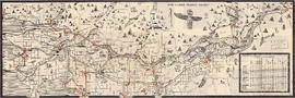
Through the Canadian Pacific Rockies : a large scale map of the mountains from Calgary to Sicamous
Part of City of Vancouver Archives technical and cartographic drawing collection
Item is a map of a portion of the Rocky Mountains including Rocky Mountains Park, Yoho Park, Kootenay Park, Glacier Park, and Revelstoke Park. Map shows rail lines, steamship routes, roads, trails, waterfalls, glaciers, rivers, elevations, and locations of amenities.
![[Third section of] Shaughnessy Heights](/uploads/r/null/b/9/c/b9c97036cadac8b6ffc53f2380c1c158d767da3473d29ad1b04968cc742d132e/0301116d-9946-489d-a272-9d6453523103-MAP331_142.jpg)
[Third section of] Shaughnessy Heights
Part of City of Vancouver Archives technical and cartographic drawing collection
Item is a map showing lot subdivisions in the portion of Shaughnessy Heights south of Thirty-seventh Avenue as of January 1st, 1931.
The service route to - from - through industrial southwestern British Columbia
Part of City of Vancouver Archives technical and cartographic drawing collection
Item is a pamphlet which shows lines operated by B.C. Hydro and Power Authority including the V & LI Branch of the Canadian Pacific Railway (the BCE Route) in Greater Vancouver. An index map of British Columbia was designed to display on the back page of the pamphlet when folded.

The service route to - from - through industrial southwestern British Columbia
Part of City of Vancouver Archives technical and cartographic drawing collection
Part is a map depicting Greater Vancouver east to Chilliwack, showing the locations of B.C. Hydro rail routes, routes of other rail companies, interchanges, industrial development sites, and municipal boundaries and 1961 census figures.
![The Seechelt [Sechelt] Forest](/uploads/r/null/e/6/d/e6d1e8d1a7613c8e7ce050434f42ef80f8e00ca339edc6e23dc578f9a4154957/c9ad5fbf-94a8-4925-8b43-b0845d5bd699-MAP54_142.jpg)
Part of City of Vancouver Archives technical and cartographic drawing collection
Item is a topographical map of the Seechelt Forest surrounding Jervis Island and Princess Louisa Inlet. Includes elevations, roads, and buildings, as well as information regarding vegetation, forestry, and land use.
British Columbia. Department of Lands and Forests. Forest Service
The Port of Vancouver, British Columbia
Part of City of Vancouver Archives technical and cartographic drawing collection
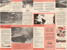
Part is the front side of a brochure on the Port of Vancouver. The page includes information on the port's history, facilities, berthing accommodations, development and
The Port of Vancouver : Canada's key city of the West
Part of City of Vancouver Archives technical and cartographic drawing collection
Item is a brochure promoting Vancouver harbour as a hub of economic activity in the city. The brochure includes illustrations of harbour activity, facts about various aspects of the operations to show the harbour's capacity and facilities.

The Municipality of South Vancouver
Part of City of Vancouver Archives technical and cartographic drawing collection
Item is a map depicting the Municipality of South Vancouver. The map has been annotated to indicate some of the routes of BC Electric Railway street car lines and surveyed extensions.
Part of City of Vancouver Archives technical and cartographic drawing collection
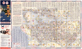
Part is a map of the greater Vancouver area, showing communities across the region, with pictographs representing various communities. The map also includes a mileage table showing driving distances between various communities in Greater Vancouver.
British Columbia. Travel Bureau

The Estate of Joseph Martin, K.C., MP
Part of City of Vancouver Archives technical and cartographic drawing collection
Part is the front side of the fold-out brochure; it includes promotional information about the estate, Vancouver, the climate, economy, land speculation in the city.
The Estate of Joseph Martin, K.C., MP
Part of City of Vancouver Archives technical and cartographic drawing collection
Item is a promotional brochure advertising the sale of lots from the former estate of Joseph Martin, K.C., MP.
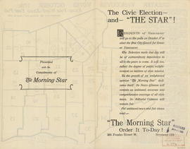
The civic election - and "The Star"!
Part of City of Vancouver Archives technical and cartographic drawing collection
Part contains text advertising The Morning Star newspaper and assuring readers of its political neutrality.

The civic election - and "The Star"!
Part of City of Vancouver Archives technical and cartographic drawing collection
Part contains text advertising The Morning Star newspaper and assuring readers of its political neutrality.

The city of Vancouver, British Columbia
Part of City of Vancouver Archives technical and cartographic drawing collection
Item is a map showing postal block numbers, streets, railroads, schools, steamship routes, beaches and hospitals in the city of Vancouver. The map has been annotated to show city parks.
Part of City of Vancouver Archives technical and cartographic drawing collection
Map is an aerial photograph of the Greater Vancouver area.
The Cape Scott settlements, 1896-1946
Part of City of Vancouver Archives technical and cartographic drawing collection
Peterson, Lester Ray

Part of City of Vancouver Archives technical and cartographic drawing collection
Part is a map of a portion of the Rocky Mountains including Rocky Mountains Park, Yoho Park, Kootenay Park, Glacier Park, and Revelstoke Park. Map shows rail lines, steamship routes, roads, trails, waterfalls, glaciers, rivers, elevations, and locations of amenities.

The asiatic part of the Russian empire
Part of City of Vancouver Archives technical and cartographic drawing collection
Item is a map sheet which appears to be a part of a map of Russia. The sheet depicts the area immediately around Lake Baikal, to the north coast and east to the Pacific, including the islands of the north-west Pacific.
Texaco Canada Limited : plan showing topography over a portion of lot 6 (explanatory plan 5390)
Part of City of Vancouver Archives technical and cartographic drawing collection
Plan drawn for Texaco Canada Limited, of area at corner of South East Marine Drive and Main Street. Includes information on electrical, telephone, sewer, gas, and water services, as well as elevations.
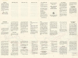
Target area civil defence survival instructions
Part of City of Vancouver Archives technical and cartographic drawing collection

Part of City of Vancouver Archives technical and cartographic drawing collection
Part is the outer/back side of an unfolded brochure for Union Steamships. The sheet includes text describing the company's services and vessels, photographs of various vessels and locations served, and a map showing the various routes in the area.
Union Steamships (Vancouver, B.C.)
Suggested civic auditorium and stadium on Kitsilano Reserve
Part of City of Vancouver Archives technical and cartographic drawing collection
Item is an oblique rendering depicting a proposed recreation complex in the current location of Vanier Park, near the south end of the Burrard Street Bridge.
Sharp & Thompson, Architects

Stuart's pocket map of Vancouver, B.C.
Part of City of Vancouver Archives technical and cartographic drawing collection
Item is an illustrated map of the "old" City of Vancouver. The map shows streets, transportation, and significant businesses (such as C.P.R. wharves, smelter, Hastings Mill, Morse's Mill, C.P.R. Shops, City Hospital, sawmill, slaughter houses, and smallpox hospital). The map includes "Index of Streets, Government Offices, Churches, [etc.], including "Civic and other Principal Buildings", "Places of Amusement or Recreation", "Public Schools", "Principal Mills, Foundries and Manufactories", "Principle Bankers", Principal Hotels", and "Miscellaneous".
The map was designed to be folded into a cover, which is included.
Streetwise Vancouver : city center street map of Vancouver Canada
Part of City of Vancouver Archives technical and cartographic drawing collection
Shows cultural sites, education/government sites, hospitals, hotels, parks, places of interest, shopping, transportation centers, pedestrian walks, cycling routes, sky train lines, etc.
Street map of Vancouver, Burnaby, New Westminster, British Columbia
Part of City of Vancouver Archives technical and cartographic drawing collection
Item is a promotional brochure for Bekins Moving and Storage Co. with a street map of Greater Vancouver on one side and information on the services and facilities of Bekins Moving and Storage on the other.

Part of City of Vancouver Archives technical and cartographic drawing collection
Part contains a street map of Greater Vancouver with street index, an inset map showing the streets of Horseshoe Bay, Whytecliff, and Caulfeild, and advertising Chevron gasolines and RPM motor oils.

Part of City of Vancouver Archives technical and cartographic drawing collection
Part contains a street map of Greater Vancouver.
Part of City of Vancouver Archives technical and cartographic drawing collection
Part is a street map of Greater Vancouver (including West Vancouver, North Vancouver, Vancouver, Burnaby New Westminster and parts of Richmond, Coquitlam and Surrey). The sheet also includes a street index and tourist information for U.S. border crossing

Part of City of Vancouver Archives technical and cartographic drawing collection
Part is a street map of Greater Vancouver, including West Vancouver, North Vancouver, and the western portion of Burnaby. The map includes concentric circles centred on the Bekins head office in downtown, noting distances in miles.

Street map of Greater Victoria, B.C., map cover, and street index of Greater Vancouver
Part of City of Vancouver Archives technical and cartographic drawing collection
Part contains a map of Greater Victoria showing highways, streets, parks, golf courses and country clubs, institutions, block numbers, city and municipal boundaries and Shell marine stations, and a street index for the Greater Vancouver map on the other side of the sheet.

Street map of Greater Vancouver, B.C.
Part of City of Vancouver Archives technical and cartographic drawing collection
Part contains a street map of Greater Vancouver showing block numbers, parks, golf courses, cemeteries, and hospitals; inset maps showing streets in Coquitlam and the Horseshoe Bay area; and a map showing Highway 99 from Horseshoe Bay to Squamish.

Street map of Greater Vancouver, B.C.
Part of City of Vancouver Archives technical and cartographic drawing collection
Part contains a street map of Greater Vancouver showing block numbers, neighbourhood boundaries, schools, churches by denomination, and main shopping centres. An inset map shows the Forest Hills - Canyon Heights area.

Street Map of Greater Vancouver, B.C.
Part of City of Vancouver Archives technical and cartographic drawing collection
Part consists of the back side of a road map. The main map is a road map of Greater Vancouver; the sheet also includes inset road maps of Coquitlam, West Vancouver, and Highway 99 to Squamish.

Street map of Greater Vancouver, B.C.
Part of City of Vancouver Archives technical and cartographic drawing collection
Part contains a map of Greater Vancouver showing highways, streets, parks, golf courses and country clubs, institutions, block numbers, city and municipal boundaries and Shell marine stations.

Street map of Greater Vancouver showing distances from Bekins building
Part of City of Vancouver Archives technical and cartographic drawing collection

Street map of Greater Vancouver : map cover, street index and advertisements
Part of City of Vancouver Archives technical and cartographic drawing collection

Street Map of Greater Vancouver
Part of City of Vancouver Archives technical and cartographic drawing collection
Part consists of a road map of Vancouver, with street index (including Vancouver, West Vancouver, North Vancouver, Burnaby and New Westminster) and an index of Vancouver schools. An inset map depicts the Canyon Heights area.
Street map of Greater Vancouver
Part of City of Vancouver Archives technical and cartographic drawing collection
Part is a street map of Greater Vancouver, from Coquitlam westward and north of the Fraser River. The sheet includes inset maps of Downtown Coquitlam, Gleneagles to Horseshoe Bay, and Highway 99 from West Vancouver to Squamish. The sheet also includes a s
Agency Press Limited
Street Map of Greater Vancouver
Part of City of Vancouver Archives technical and cartographic drawing collection
Part is a page with three maps. The main map shows Greater Vancouver including the municipalities of West and North Vancouver, Burnaby, New Westminster and a portion of Coquitlam. The two inset maps show Horseshoe Bay and Highway 99 to Squamish.
Street map of Greater Vancouver
Part of City of Vancouver Archives technical and cartographic drawing collection
Item is a published road map, created for and distributed by Home Oil Distributors, with a map of Greater Vancouver on one side and maps of the Fraser Valley, Surrey and Richmond (iwth street indexes) on the other. The maps show roads, block numbers, boundaries, highway markers and Home Oil gas stations.
Street Map of Greater Vancouver
Part of City of Vancouver Archives technical and cartographic drawing collection
Part is a street map of Greater Vancouver, from Coquitlam westward and north of the Fraser River. The sheet includes inset maps of Downtown Coquitlam, Gleneagles to Horseshoe Bay, and Highway 99 from West Vancouver to Squamish. The sheet also includes a s
Agency Press Limited

Street index (Royal Oak Avenue, Vancouver to Frederick Road, North Vancouver)
Part of City of Vancouver Archives technical and cartographic drawing collection
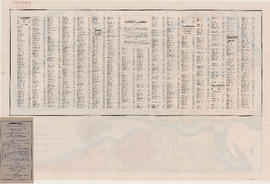
Part contains two pages from the booklet accompanying a guide map of Greater Vancouver. Pages include the last portion of the Vancouver and Burnaby street index, the New Westminster street index, and the North Vancouver street index from 1st Street to Frederick Road.

Street index of Vancouver and lower mainland
Part of City of Vancouver Archives technical and cartographic drawing collection
Part contains the street index for a map of Greater Vancouver and advertisements for Roy Wrigley Printing and Publishing Co. and A.E. Austin and Co. Limited.
Street index of Vancouver and Lower Mainland
Part of City of Vancouver Archives technical and cartographic drawing collection

Street index of Vancouver and Lower Mainland
Part of City of Vancouver Archives technical and cartographic drawing collection

Street index (Gibson Street to William Street) and tram stations
Part of City of Vancouver Archives technical and cartographic drawing collection
Part is a page from the booklet accompanying a guide map of Greater Vancouver, and contains the last portion of the North Vancouver street index, the West Vancouver street index, and a list of Vancouver tram stations.

Street index (Campbell Street to Rosser Avenue)
Part of City of Vancouver Archives technical and cartographic drawing collection
Part contains two pages from the booklet accompanying a guide map of Greater Vancouver.

Part of City of Vancouver Archives technical and cartographic drawing collection
Part of City of Vancouver Archives technical and cartographic drawing collection