Title and statement of responsibility area
Title proper
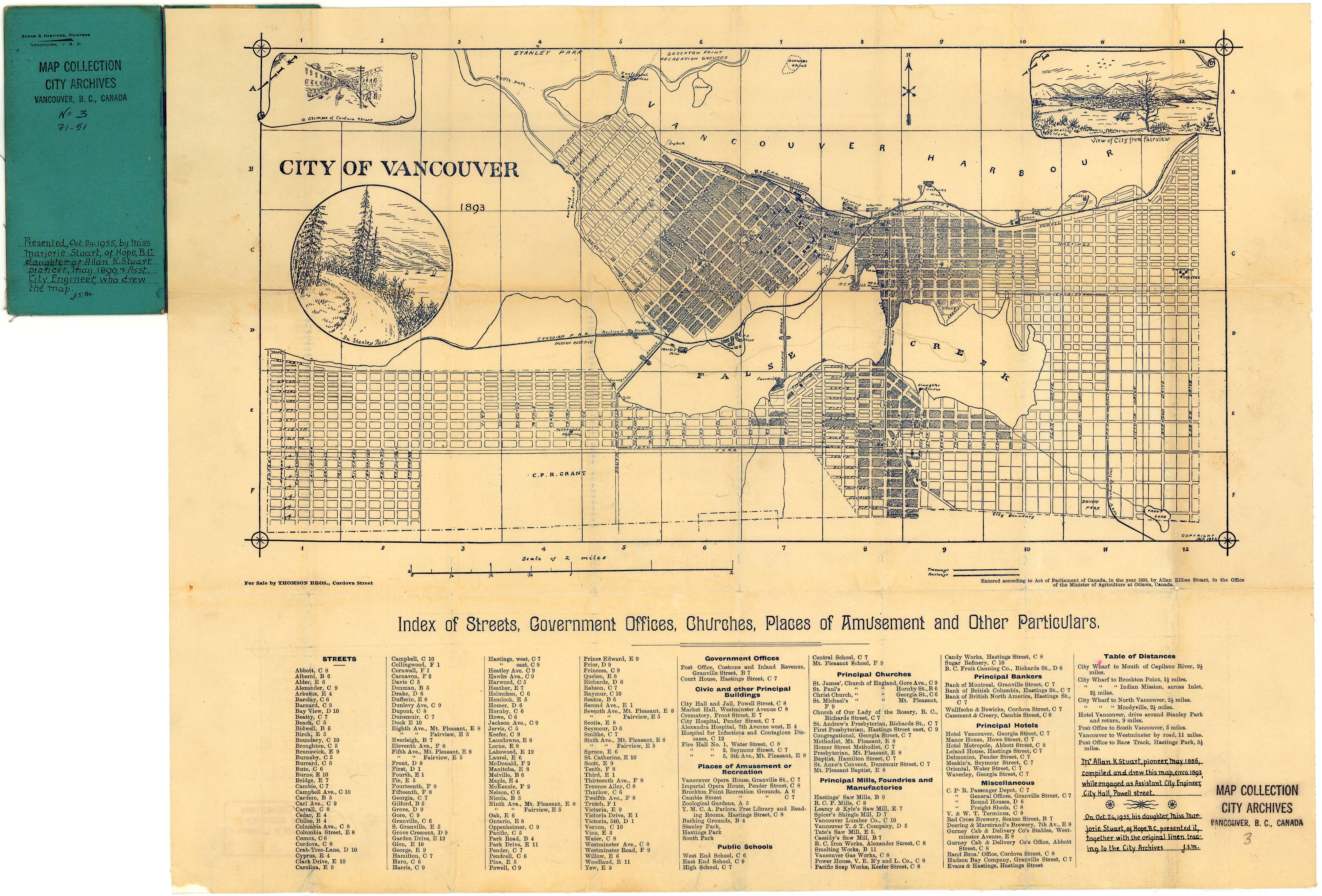
Stuart's pocket map of Vancouver, B.C.
General material designation
- Cartographic material
Parallel title
Other title information
Title statements of responsibility
Title notes
Level of description
Item
Reference code
Edition area
Edition statement
Edition statement of responsibility
Class of material specific details area
Statement of scale (cartographic)
Scale [1:21,120]
Statement of projection (cartographic)
Statement of coordinates (cartographic)
Statement of scale (architectural)
Issuing jurisdiction and denomination (philatelic)
Dates of creation area
Date(s)
Physical description area
Physical description
1 map : lithographic print, ill. ; 42 x 55 cm + cover
Publisher's series area
Title proper of publisher's series
Parallel titles of publisher's series
Other title information of publisher's series
Statement of responsibility relating to publisher's series
Numbering within publisher's series
Note on publisher's series
Archival description area
Custodial history
Scope and content
Item is an illustrated map of the "old" City of Vancouver. The map shows streets, transportation, and significant businesses (such as C.P.R. wharves, smelter, Hastings Mill, Morse's Mill, C.P.R. Shops, City Hospital, sawmill, slaughter houses, and smallpox hospital). The map includes "Index of Streets, Government Offices, Churches, [etc.], including "Civic and other Principal Buildings", "Places of Amusement or Recreation", "Public Schools", "Principal Mills, Foundries and Manufactories", "Principle Bankers", Principal Hotels", and "Miscellaneous".
The map was designed to be folded into a cover, which is included.
Notes area
Physical condition
Annotation by City Archivist J. S. Matthews: "Mr. Allan K. Stuart, pioneer, May 1886, compiled and drew this map . . . while engaged as Assistant City Engineer, City Hall, Powell Street".
Immediate source of acquisition
Arrangement
Language of material
Script of material
Location of originals
Availability of other formats
A digitized copy of this material is available on-line.
Restrictions on access
Terms governing use, reproduction, and publication
Finding aids
Associated materials
MAP 230 is the original artwork for the map image. Photostat copies held in AM54-S13 oblong S.74 de-accessioned.
Accruals
External Link
ftp://webftp.vancouver.ca/archives/MAPS-TIFF/MAP3.tif
Format: TIFF (LZW compressed)
MD5: 339F45CAAC91671CEAF84663B6422368
Size: 37830600 bytes
Rights
Public domain
Alternative identifier(s)
Standard number area
Standard number
Access points
Place access points
Name access points
- [s.n.] (Publisher)