Yale Hotel and Yale Gardens [tourist map of Vancouver]
Yale Hotel and Yale Gardens [tourist map of Vancouver]
Wrigley's new revised official map of Greater Vancouver
Wrigley's new revised official map of Greater Vancouver
Wrigley's 1930 map of Vancouver and Lower Mainland
Wrigley's 1930 map of Vancouver and Lower Mainland
Western Canada
Western Canada
West Vancouver
West Vancouver
West section Richmond municipality
West section Richmond municipality
Waterworks map of City of Vancouver
Waterworks map of City of Vancouver

Warehouse and store sites : very centrally located
V.W.W. [Vancouver Water Works] plan shewing tunnel and tramway at Big Canon [Canyon]
V.W.W. [Vancouver Water Works] plan shewing tunnel and tramway at Big Canon [Canyon]
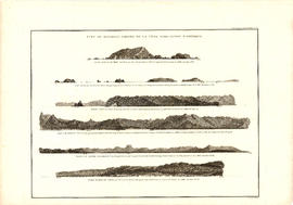
Vue de diverses parties de la côte nord-ouest d'Amérique
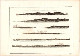
Vue de diverses parties de la côte nord-ouest d'Amérique
Visitors map. Southwestern British Columbia & Greater Vancouver, Canada
Visitors map. Southwestern British Columbia & Greater Vancouver, Canada
Visitors map of Vancouver
Visitors map of Vancouver
Visitors map of Vancouver
Visitors map of Vancouver
Visit the Scenery Shop, souvenir headquarters
Visit the Scenery Shop, souvenir headquarters
Views of Chilliwack valley and town
Views of Chilliwack valley and town
Victoria and Vancouver street and vicinity maps
Victoria and Vancouver street and vicinity maps
Vest pocket map of Vancouver
Vest pocket map of Vancouver

Vancouver, New Westminster, Delta and Surrey : postal area

Vancouver, Canada

Vancouver, British Columbia, south-easterly portion, formerly South Vancouver : major street plan
Vancouver, British Columbia, Canada
Vancouver, British Columbia, Canada
Vancouver, British Columbia. Souvenir from the lion gateway
Vancouver, British Columbia. Souvenir from the lion gateway
Vancouver, British Columbia : [urban analysis maps]
Vancouver, British Columbia : [urban analysis maps]

Vancouver, British Columbia : south-westerly portion, formerly Point Grey : major street plan

Vancouver, British Columbia : northerly portion, former City of Vancouver : major street plan

Vancouver, British Columbia

Vancouver, British Columbia

Vancouver, British Columbia
Vancouver, British Columbia
Vancouver, British Columbia

Vancouver, British Columbia
Vancouver, British Columbia
Vancouver, British Columbia
Vancouver, B.C., the Pacific coast terminus of the C.P.R. [Canadian Pacific Railway]
Vancouver, B.C., the Pacific coast terminus of the C.P.R. [Canadian Pacific Railway]
Vancouver, B.C., the Pacific coast terminus of the C.P.R. [Canadian Pacific Railway]
Vancouver, B.C., the Pacific coast terminus of the C.P.R. [Canadian Pacific Railway]
Vancouver, B.C., Pacific terminus of the C.P.R.
Vancouver, B.C., Pacific terminus of the C.P.R.
Vancouver, B.C., Pacific terminus of the C.P.R.
Vancouver, B.C., Pacific terminus of the C.P.R.
Vancouver, B.C. zoning diagram
Vancouver, B.C. zoning diagram

Vancouver, B.C. Plan showing location of water pipes, hydrants, etc. [Westminster Avenue to McLean Drive]
![Vancouver, B.C. Plan showing location of water pipes, hydrants, etc. [West End]](/uploads/r/null/0/5/05354f71931ba85b05864a2adeb3580a6365ddf962e5084f0bb51c68608364a0/3f57f512-bd27-404e-a332-e0881405c2ac-MAP72_142.jpg)
Vancouver, B.C. Plan showing location of water pipes, hydrants, etc. [West End]

Vancouver, B.C. Plan showing location of water pipes, hydrants, etc. [Victoria Drive to First Avenue to Prince Edward Street to 16th Avenue]
![Vancouver, B.C. Plan showing location of water pipes, hydrants, etc. [South Granville]](/uploads/r/null/e/a/eadb6d7351a77ac5788832abd83754cbe2966049728712aa7773bf6f2a74ff34/819e5ce5-621b-43ff-b1f5-f3bf4cac0562-MAP72_142.jpg)
Vancouver, B.C. Plan showing location of water pipes, hydrants, etc. [South Granville]
![Vancouver, B.C. Plan showing location of water pipes, hydrants, etc. [Kitsilano]](/uploads/r/null/0/e/0e33cc4d2f081f551fe6919d35ea37236a6e237a2f5927834d275556995fccfc/0f6ac1ff-8457-41f3-a386-26328c66a4b0-MAP72_142.jpg)
Vancouver, B.C. Plan showing location of water pipes, hydrants, etc. [Kitsilano]
![Vancouver, B.C. Plan showing location of water pipes, hydrants, etc. [Hastings Sunrise]](/uploads/r/null/b/c/bc8cb6a6f5ac5df0dd88a65e8a29ecceca242bde2c1b605533ad17eb835cc450/b2741291-73c5-4a98-9f41-db7fdc46fe83-MAP72_142.jpg)
Vancouver, B.C. Plan showing location of water pipes, hydrants, etc. [Hastings Sunrise]
![Vancouver, B.C. Plan showing location of water pipes, hydrants, etc. [Hastings Park area]](/uploads/r/null/0/c/0c5e2bf211ef2e6dfd7a025d620f00d0e64653f3c8080a7e2b3699fffe60e5a3/22c75a7d-7301-4578-8f71-378ca61a6b27-MAP72_142.jpg)
Vancouver, B.C. Plan showing location of water pipes, hydrants, etc. [Hastings Park area]
![Vancouver, B.C. Plan showing location of water pipes, hydrants, etc. [Grandview]](/uploads/r/null/8/8/88632d271347b57b818fde723ce9ea599c725a5190b4fb2bbb11e5f98e3809ae/3657fbb2-2cf9-4d03-b885-3836ab221252-MAP72_142.jpg)
Vancouver, B.C. Plan showing location of water pipes, hydrants, etc. [Grandview]
![Vancouver, B.C. Plan showing location of water pipes, hydrants, etc. [Fairview slopes]](/uploads/r/null/6/9/69e0d6904facfa2a814069c15122fba46fc4d8077bff76402e95484a4b13d4d8/313b8940-1e98-45d4-b077-abe0f6bee66a-MAP72_142.jpg)
Vancouver, B.C. Plan showing location of water pipes, hydrants, etc. [Fairview slopes]
![Vancouver, B.C. Plan showing location of water pipes, hydrants, etc. [Burrard Street to Gore Avenue]](/uploads/r/null/7/7/7797d041e72dece35da90eab6733a9db50a0b2115ad816578d3633a58bf31761/ebc0f54a-c23a-425c-816d-1dd268a2e4e7-MAP72_142.jpg)
Vancouver, B.C. Plan showing location of water pipes, hydrants, etc. [Burrard Street to Gore Avenue]
Vancouver, B.C. city map
Vancouver, B.C. city map
Vancouver, B.C. and vicinity road map
Vancouver, B.C. and vicinity road map

Vancouver, B.C. 1890 : built-on area