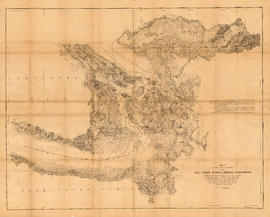
Map showing the line of boundary between the United States and British possessions
- AM1594-: MAP 8a
- Item
- [1846?]
Part of City of Vancouver Archives technical and cartographic drawing collection
Item is a map showing four proposed boundaries between the United States and British possessions in the Salish Sea region. The explanations of the lines read in part: "[1] Boundary line contemplated by the Treaty as shown by contemporaneous evidence; [2] Boundary line as claimed by the British Commissioner; [3] Boundary line proposed by the British Commissioner as a compromise ( . . . ); [4] Boundary line in accordance with the strict letter of the Treaty ( . . . ). Item also shows soundings, and the "track of steamers plying between Victoria and Fraser river since discovery of gold."
![[View of New Westminster from across the river]](/uploads/r/null/8/f/8f82aebb4c849e2bb1f74b79994fab8be690ff186aaa671c5ae8a966dbdf8a2f/2ca5abb4-a6d5-443d-85bc-25dcc6f7e5bd-A33970_142.jpg)
![[Governor Seymour's coach at the foot of the hill on Columbia Street]](/uploads/r/null/d/e/def6b0addc83ac05b40f2ea304f7ffe30183a03d2b082578b0387b1ed81e2142/717577a0-cf9f-41c6-be48-b0dd985e9df6-A26753_142.jpg)


![[Men making "Kus-kis" in camp at] New Westminster](/uploads/r/null/6/d/6dc02252100dd7f2571ffccda11a57b5243f1482e0f685223953c766c7dbb3ee/21e54e49-5a43-427b-a287-81bcef270429-A26497_142.jpg)
![[View of New Westminster from across the Fraser River]](/uploads/r/null/5/8/582348267ebed621eea9e6ed1fc420557e664609ee6fb2b12f46246410edfcc7/245a5c03-32fc-4820-8318-0add14d4e8ff-A33832_142.jpg)
![[Hyack Fire Company firemen in front of Fire Hall on Columbia Street]](/uploads/r/null/9/c/9c63be9436e5916f78d23b23f643ce3f770c007961681b7d23f5b38998aaea23/3449ddd0-21f6-4995-afee-a8cf25c70054-A26125_142.jpg)
![[First] May Day [Queen of the May celebration] New Westminster, B.C.](/uploads/r/null/e/a/eac8d3d29da4a019f1dce1518a1cf41c77c52bf7edd391ec5baaef49982b9fb3/120b048c-944b-4296-990b-3305cc884322-A32002_142.jpg)
![[The Bonson family]](/uploads/r/null/1/c/1c32d65e3e4f94adadb96cef53f4525e4579d6409b5b5b11fa595715982de1ea/c0ebca12-8686-4c6b-a0e8-26ba3deb9dd2-A47239_142.jpg)
![[Second May Queen celebration at Queens Park, New Westminster]](/uploads/r/null/a/f/af64748c184c7a1c17036f5adced3b6a88e2d9cd43518beea9661c415191e496/97e8b9a3-dc0a-417d-a8ef-f891e9b0e67b-A32001_142.jpg)
![[Mr. and Mrs. Charles Sitbald Lockwood Street with two of their daughters]](/uploads/r/null/e/e/ee331073705f8271ee94402a82f7bcc3ed9f25f0dc15e94779a091a6f488acd5/1bd0c7dc-7793-461c-ae95-43a9d29c6501-A62790_142.jpg)


![[Mrs. Angus Grant]](/uploads/r/null/8/8/8882cba6a1016b7e56f4f821ef1e53350c53ce6e82ae2a79c8b535a35167ad31/3e453fa9-f42a-420d-bd78-93573bd50984-A35167_142.jpg)
![[Exterior of Hugh McRobert's home]](/uploads/r/null/2/4/2432a9aaa55c309cdad01bc85f52ee7dc5132cd7e660d91d3cc7711fb4c9c15d/51a3b9a3-1399-4202-bd1f-3c274defe43b-A25192_142.jpg)

![[James Kay Suter]](/uploads/r/null/1/8/18de6470b233c6ee4d9e7241ceb9925ebcad32aae36eeb39ccf59cd80c86b93c/40d9394a-1e79-4231-a5bc-c73ecc335a24-A34595_142.jpg)
![[Caleb Woodward]](/uploads/r/null/3/4/341bc2b4a81dff6a893b571d021645714d02cf59dcfb104d50204e3c91d20e65/7419c6f1-449c-4792-ab0e-24de679b26c7-A35447_142.jpg)


![[Mrs. Wintemute]](/uploads/r/null/1/6/165ad1f0c4996e2bc59235e699a9520a52362e7f1e30abf9016d51eec9ca9cc8/b037b5ae-2be1-4743-8cad-81b8e361ad18-A59867_142.jpg)
![[Captain Angus Grant]](/uploads/r/null/6/c/6cc2150235acbe1e651c717ed57209cfc60155ac69d685cf1f9b555d4d0d393c/b5b7ddcd-2f48-4278-b8fe-643651380fdd-A35166_142.jpg)
![[Miss Edith Cordiner (Mrs. Charles Nelson)]](/uploads/r/null/e/7/e72c1dbd87770e19217846ed18ede2451ec437c02b510ef2f8f549a0827baa70/8697fafe-10f7-4d99-bc21-4144186dfe41-A35240_142.jpg)
![[Mrs. William Clarkson]](/uploads/r/null/1/0/104a103c6f00e829e650dcc2584a97b10e8ec174cdd8de1be6334e44c033bdbf/6a714a21-51e1-49c0-b11d-72a8fca96504-A35440_142.jpg)
![[William Clarkson]](/uploads/r/null/1/9/1954b9bacff02ebddd7ac31376ea02ce9f32d5bba98fe55b17974e5ced975c41/bd2e2d73-ed5a-4131-8068-19d263e2b038-A35439_142.jpg)
![[Mrs. Peter Plante (nee Ada Guinne)]](/uploads/r/null/5/4/547bf66acf7a86bf77e4b37475ce295f80686ffcc760319f6f862a009c0582f6/4875431f-8110-4c66-8f1a-f5253bb63e13-A34955_142.jpg)
![[George Wintemute]](/uploads/r/null/9/7/972b925ccb55d3981b13f247d6da7c2d974d8ae1e3477a34bdeeab242c118f00/c49fb047-e0e9-4837-952d-5b1ec2ecaac2-A59866_142.jpg)
![[Mrs. Elizabeth Ann Mole (nee Cornish)]](/uploads/r/null/8/0/80d9747c4319dd12908faa3a93ca3561f535cb1c30a6906e3eb0086d94d77c4d/66c93a3b-9374-4c38-93f1-533208b70a6f-A34669_142.jpg)

![[Dr. R.I. Bentley and an unidentified man]](/uploads/r/null/c/5/c5a330df88075e8d1af9e45f90e859a6571a30c0700eabc9043e120e70bb70aa/baf9d1cc-b87b-44de-a364-c48e6006ca40-A61762_142.jpg)
![["K de K" steam ferry on the Fraser River]](/uploads/r/null/1/6/168ca7e80306cd7b4ada4405448bbac0757015f46a253989663d19d9b4357eb5/c96f969a-f6e9-4321-b0cb-8d0a66fe7c5e-A37372_142.jpg)
![[W.R. Lewis]](/uploads/r/null/f/a/fa6d723db7dbcc5ab5acd7c605e39ce7e75ec21f4c98ac8c21934798e34dc918/b87754c4-ef8a-4b29-9bc7-eb317d824924-A34407_142.jpg)
![[Mrs. Art Clemes]](/uploads/r/null/d/5/d518cf187ec53d99e78797c636ac68369a6e8e3e2d514cd3f06d3dadb086a3c0/ac6fc715-c537-4fed-9844-d7a3fbb8c800-A35583_142.jpg)
![[Mrs. Handcock]](/uploads/r/null/e/e/ee97018b3ca2cea31e58bd26d56a6eadcdd751893ce0fd3d572ff72ca06c05c2/7c9ee960-9f20-45c7-919f-1eea80929f9b-A61879_142.jpg)
![[William Handcock]](/uploads/r/null/4/d/4d5c5aac146c93fb1f37c0da1d1552f4be5460c60f5c72174fa5956b19342b7c/b77a3a47-1c11-4805-b352-d4add84c3d3f-A61880_142.jpg)
![[John Handcock]](/uploads/r/null/d/7/d7f607c5142d2443f35ec7f78630f0f07b0cc08a47586abbfb9bdec4ba08f266/5705ea50-c9bd-44af-91cb-6a61ef557b02-A47197_142.jpg)
![[Miss Alberta Fagan (Mrs. A.M. McGovern)]](/uploads/r/null/1/9/19c62ce48943e87d73686e9963714839e457823a0c664cfb142d1289d34c4016/3a048156-dd3e-4aa1-bfc1-2fa14aa087b4-A34600_142.jpg)
![[The future site of Queen's Park]](/uploads/r/null/f/4/f4d14aee4c7dc5530135124aafa0e6b2680d518541ccaf2ef0d7890a14a7d627/4886a8c8-b820-45c3-9d72-93cfa01a0c0e-A26749_142.jpg)