Interurban timetables, effective October 14th, 1917
- AM1519-: PAM 1917-14
- Item
- 1917
604 results with digital objects Show results with digital objects
Interurban timetables, effective October 14th, 1917
It's amazing - the progress we've made in B.C.

Part of William Orson Banfield fonds
![[J.A.] McIntyre](/uploads/r/null/8/9/9/899606c21e2b58f288ec72fc4e1bda7f82473b5d23b9935c386cf3ee0aafd1f2/14010f6c-841f-4841-babf-3da6a7188ae0-CVA289-002_142.jpg)
Part of William Orson Banfield fonds
![[J.A.] McIntyre and Rae](/uploads/r/null/3/1/e/31e6995638c0acb2deac17d4b2cb0e8577225898cb5b0e49d15b646aa4ac1f0b/21877e73-f91c-4c94-b035-24022bc62abd-CVA289-002_142.jpg)
Part of William Orson Banfield fonds

Jack Fish Point, North Shore Lake Superior
Part of Major Matthews collection
Photograph shows a trestle bridge near the shore of the lake.

Just finishing off with the air dumps
Part of William Orson Banfield fonds
![Kamloops, B.C. on C.P.R. [route]](/uploads/r/null/e/a/0/ea0443d7d78dee9c88ac6c16f93423611f318782a8cdc5b427c7748e0062d430/4dfe9e24-91b0-444f-b492-414c4529344e-CVA256-02_142.jpg)
Kamloops, B.C. on C.P.R. [route]
Part of Elizabeth Abbott fonds

Part of Richard H. Trueman fonds

Part of Major Matthews collection

Le Roi Mine, shipping ore, Rossland, B.C.
Part of Elizabeth Abbott fonds
Part of Elizabeth Abbott fonds
Lining the Connaught Tunnel : series three, engineering and construction notes
Linking the Atlantic to the Pacific ocean to ocean
![Looking across Loop, Selkirk M[ountains]](/uploads/r/null/e/2/e275bb85c47afed5b2d207613d4e79766f9afed2a1edffc57266d6ae5f770c75/49b681b5-70aa-49af-8968-00e6144e138a-A19423_142.jpg)
Looking across Loop, Selkirk M[ountains]
Part of Richard H. Trueman fonds

Looking Up Kootenay River from N. and S. Railway, Nelson, B.C.
Part of Major Matthews collection
![Loop, C.P.R. Selkirk M[oun]t[ain]s, showing four tracks](/uploads/r/null/b/0/b0a0cf5ee473bc74bbea9f30cb21753320f8c5e3dda92cf26b3f776daec2397e/22db0e41-8a5f-462f-9988-1bf40dfabcc6-A19463_142.jpg)
Loop, C.P.R. Selkirk M[oun]t[ain]s, showing four tracks
Part of Richard H. Trueman fonds
!["Loop," C.P.R., Selkirk M[ountains]](/uploads/r/null/9/4/9467229e1860d76119fc10341e39761633ad8c254f6a685743f7e26eb1fc49db/d8e72391-0290-4ea1-bc52-69429979a234-A19424_142.jpg)
"Loop," C.P.R., Selkirk M[ountains]
Part of Richard H. Trueman fonds

Lord Stanley and party at a station beside C.P.R. engine #377 on the historic trip west
Part of Elizabeth Abbott fonds
![[Lord Strathcona driving the last C.P.R. spike]](/uploads/r/null/b/a/ba70f425a54f07cfb3d7961026759656a9bed0bfaeec2735cb7465d83231b9ba/edb174b3-d28f-427b-bfe9-44c62d264b86-A25410_142.jpg)
[Lord Strathcona driving the last C.P.R. spike]
Part of Major Matthews collection
Men identified: 1. Frank Brothers, 2. Major Rogers, 3. M.J. Haney, 4. Sir William Van Horne, 5. Sir Sanford Fleming, 6. Hon. Donald Smith (Lord Strathcona), the boy is Edward Mallandaine, 7. H.J. Cambie, 8. Mr. Miller, 9. John McTavish, 10. George R. Harris, 11. J.M. Egan, 12. James Ross, 13. Jimmy French, 14. Arthur Piers

Lower Kicking Horse Canyon near Golden, B.C.
Part of Richard H. Trueman fonds
Image shows C.P.R. line to the left of the canyon.
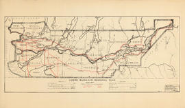
Lower Mainland Regional Plan : base map
Part of Community Planning Association of Canada, British Columbia Division fonds
Item is a map showing city, municipal district, provincial, and regional plan boundaries, trunk highways, main roads, railways, airports, customs ports, and historical monuments. Item is the base map for the other Lower Mainland Regional Plan maps in the file.
Part of Bushnell family fonds


Part of Major Matthews collection

Man in rowboat on floodwaters at washed out railroad tracks
Part of Elizabeth Abbott fonds

Item is a map of the Fraser Valley from Vancouver to Chilliwack showing roads, railway lines, schools, churches, and post offices.

Map of Fraser Valley, British Columbia
Item is a map showing trunk roads, main and local roads, and railway lines.

Map of Manitoba, Keewatin, British Columbia, and North West Territory
Part of City of Vancouver Archives technical and cartographic drawing collection
Item is a map showing the route of the Canadian Pacific Railway through western Canada.

Part of City of Vancouver Archives technical and cartographic drawing collection
Item is a map showing the extent of the Canadian Pacific Railway Company (C.P.R.) in Canada in 1883. Map shows boundaries, roads, trails, telegraph lines, towns, rivers, lakes and mountainous terrain in British Columbia, the North West Territory (Alberta, Athabasca, Saskatchewan, Assiniboia), Manitoba and Kewaydin, as well as some of Ontario and Western Quebec. Map is folded inside a book titled "North West Territory, Canada."
Map of railway freight lines operated by British Columbia Hydro and Power Authority
Part of City of Vancouver Archives technical and cartographic drawing collection
Item is a map showing the B.C. Electric railway (including the Vancouver and Lulu Island branch), other railways, interchange points and municipal city boundaries. Map is designed to be folded in two; cover on verso.

Map of the city of Vancouver, British Columbia
Part of City of Vancouver Archives technical and cartographic drawing collection
Item is a map showing railways, car lines, postal block numbers, churches, schools, fire halls, steamship routes, and waterfront businesses. Map is designed to be folded into a small cover stamped "Can be obtained at Galloway's Book Store, 307 Main Street (cor. Cordova), Vancouver, B.C."
Map of the Fraser Valley showing railway lines and district lots
Part of City of Vancouver Archives technical and cartographic drawing collection
Item contains a map of the Fraser Valley showing railway lines and district lots on one side and text advertising the British Columbia Electric Railway Company's interurban lines on the other.

Map of the Fraser Valley showing railway lines and district lots
Part of City of Vancouver Archives technical and cartographic drawing collection

Map of the municipalities of New Westminster City and District, British Columbia
Part of City of Vancouver Archives technical and cartographic drawing collection
Part contains a map of the Lower Mainland and Fraser Valley from the Gulf of Georgia in the west to Harrison Lake in the east. Map shows locations of churches, schools, canneries, sawmills, brickyards, tanneries, woolen mills and hatcheries; existing and proposed railways; and roadways.
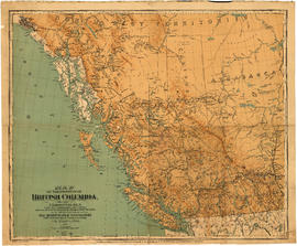
Map of the Province of British Columbia
Part of City of Vancouver Archives technical and cartographic drawing collection
Item is a a map of the province of British Columbia as well as parts of Alberta and the Northwest Territories. The map depicts the route of the Canadian Pacific Railway, including all the stations between Calgary and Vancouver. Also shown are the railways between Nanaimo and Victoria on Vancouver Island and between Edmonton and Calgary in Alberta
Map of Vancouver Unemployment and Relief [BC]
Part of City of Vancouver Archives technical and cartographic drawing collection
The map shows relief and elevations of Vancouver. It depicts streets, parks, and railways, and residential and industrial areas.
The annotations in black ink trace parts of the map: names, railways, and the coast line. The amendments also show Cases and Persons of Domiciled Residents in the Vancouver Area, in May 1934. The map also lists statistics of approximate Cases and Persons of Transient Families and Single Women, and Single Homeless Men.
Pensions and Compensation statistics are also compiled for: Mothers Pensions, Old Age Pensions, War Pensions, amd Workmen's Compensation as of the population of Vancouver in 1931.
The westernmost boundary of the map is Boundary Road and the easternmost boundary is the University of British Columbia while the northernmost is the Burrard Inlet and the southernmost is Sea Island and Lulu Island.

Map of Vancouver, New Westminster, Steveston and the Lower Mainland District
Part of City of Vancouver Archives technical and cartographic drawing collection
Item is a map which shows major roads and C.P.R. lines in Vancouver, New Westminster, Steveston, and the Lower Mainland District. The map also shows sea routes and distances to various ports.

Part of City of Vancouver Archives technical and cartographic drawing collection

Map showing route Vancouver to Mission
Part of City of Vancouver Archives technical and cartographic drawing collection
Item is a map showing a proposed railway route from Vancouver to Mission and other existing and proposed railways (Canadian Pacific Railway, Canadian Northern Railway, BC Electric Railway, and Victoria, Vancouver, and Eastern Railway), navigable and tide waters, highways and street systems.
![Maria Island [under water]](/uploads/r/null/e/6/e6f0145d1deb2da5ce494482a5859de58d7ea400f5dcfc0a3095961bad4a0b95/67f9f9d0-6308-4ec6-ba81-f3052039aa46-A33070_142.jpg)
Part of Major Matthews collection
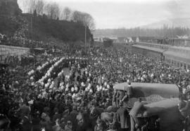
![[Mayor Harrison and an unidentified man during the launch of "The Canadian"]](/uploads/r/null/a/b/ab02bff2de4e0f9d2eed56bc77882f6fb8cdd1e6f67d8b2e67c941ee477a79ce/aa537761-83d9-4b92-8cab-49886ffd4cf6-A70850_142.jpg)
[Mayor Harrison and an unidentified man during the launch of "The Canadian"]
Part of H.A. Price collection
![[Mayor Harrison and other men on platform at the launch of "The Canadian"]](/uploads/r/null/8/7/879e237082c75e20af2f86909bc9fca4e4e04b63ef8e5adb50be373cd60dda58/e5f55e49-3d05-4013-b2e7-a1e52a41dea4-A70851_142.jpg)
[Mayor Harrison and other men on platform at the launch of "The Canadian"]
Part of H.A. Price collection

McCulloch's wonder : the story of the Kettle Valley Railway.