
[William Mason being interviewed during the launch of "The Canadian".
- AM358-S1---: CVA 152-60
- Item
- [Apr. 24, 1955]
Part of H.A. Price collection
[William Mason being interviewed during the launch of "The Canadian".
Part of H.A. Price collection

[William Manson, Vice President, CPR, and Major J.S. Matthews during the launch of "The Canadian"]
Part of H.A. Price collection

[William Manson, Norman MacKenzie and an unidentified man during the launch of "The Canadian"]
Part of H.A. Price collection
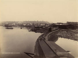
![[Western Canada Shipyards, False Creek]](/uploads/r/null/5/3/53d0a0e17c1710a62fbd39eaed21efd8d1773a33701bcceab1cc3c12366fc39c/020f20b5-8330-4847-81b0-3aac74b51033-A63958_142.jpg)
[Western Canada Shipyards, False Creek]
Part of Major Matthews collection
Photograph shows four ships under construction and the G.N.R. Trestle and Granville bridges
![Waiting [on the C.P.R. platform] for the Atlantic Express](/uploads/r/null/c/e/cebabea5840ad4ac47b8e88dac764d158206e6f3969492d19eeef725adef71a0/16f22561-7532-4622-a832-7c93c30f115f-A25343_142.jpg)
Waiting [on the C.P.R. platform] for the Atlantic Express
Part of Major Matthews collection
![[View to the north from the CMI Industries Building rooftop - 1345 West Georgia Street]](/uploads/r/null/5/9/59ae5f04a287d9ec5373734fd20af46068953432ebf1679be0f5eb46f9a2b204/a45214e4-28dc-439d-81a7-0ddadeab8426-A25261_142.jpg)
[View to the north from the CMI Industries Building rooftop - 1345 West Georgia Street]
Part of Major Matthews collection
Photograph shows North Vancouver, Coal Harbour and C.P.R. (Canadian Pacific Railway) tracks

Part of Major Matthews collection
![[View of the C.P.R. tracks looking west from Campbell Avenue]](/uploads/r/null/b/1/b1f1d917ace4fcaf7f5aac93625eab1d19fff5fbbbbbcf32b781c71b2c41f1f7/5085e976-1c44-4859-b234-efc8bd6a6ad6-A70773_142.jpg)
[View of the C.P.R. tracks looking west from Campbell Avenue]
Part of H.A. Price collection
Photograph shows a B.C. Sugar Refining Co. Ltd. building on the left and on the right it shows a house (980 Powell Street) Ramsay Brothers Ltd. (210 Raymur Avenue), houses in the 1000 block Powell Street and cabins (1100 Powell Street).
![[View of the C.P.R. tracks looking east from Campbell Avenue]](/uploads/r/null/c/f/cfaefbf5a355900c58bba274c3fe63744c81dfd8af7e29df27ad52d11d7857e6/edd43f6a-7f10-416d-8558-9030ca740a80-A70771_142.jpg)
[View of the C.P.R. tracks looking east from Campbell Avenue]
Part of H.A. Price collection
Photograph shows a B.C. Sugar Refining Co. Ltd. building on the left and on the right it shows a house (980 Powell Street) Ramsay Brothers Ltd. (210 Raymur Avenue), houses in the 1000 block Powell Street and cabins (1100 Powell Street).

Part of H.A. Price collection
Photograph also shows the Barnard Castle Hotel (898 Powell Street and Campbell Avenue), buildings in the 700 block Powell Street, a floating wharf and the B.C. Wire and Nail Co. Ltd. building at the foot of Hawkes Avenue and a wooden sidewalk.
![[View of railway tracks and cars, buildings, and other structures at east end of Georgia Viaduct]](/uploads/r/null/8/a/8a4ae0c87d5c5c8e582fad2a73d1785c2b0bdf2a8115c74f39a7917fe2f838b9/a288b146-e76d-44cf-9969-39055b535dde-A08323_142.jpg)
[View of railway tracks and cars, buildings, and other structures at east end of Georgia Viaduct]
Part of Major Matthews collection
![[View of railroad tracks through forest]](/uploads/r/null/c/0/c0a68fd94c3f78f5d4493439bff79e6a672069b1a474e4d04cbb4d702280d7a3/3ef0b354-c81e-4b70-af19-5590e4ea243d-A01782_142.jpg)
[View of railroad tracks through forest]
Part of Stuart Thomson fonds
![[View of Powell Street looking west from Raymur Avenue]](/uploads/r/null/5/7/57d92e0b18197baa7cff44a1660ceab99f0701dd4cc1755378e6d61a277960ec/df630963-de0e-4fa1-8ed8-77fb033b1193-A70770_142.jpg)
[View of Powell Street looking west from Raymur Avenue]
Part of H.A. Price collection
Photograph shows CPR tracks and buildings on the B.C. Sugar Refinery Co. Ltd. property on the waterfront side of Powell Street. Photograph also shows Ramsay Brothers & Co. Ltd. (210 Raymur Avenue), a house (922 Powell Street) the Barnard Castle Hotel (898 Powell Street), Vancouver Junk Company storehouse (755 Powell Street) and other buildings in the 700 block of Powell Street . A B.C. Electric Streetcar is on Powell Street at Campbell Avenue.
![[View of Powell Street looking west from Raymur Avenue]](/uploads/r/null/f/3/f30ffc417caefd00150a32ebb4118014cd0fcc2cc0d3efdef2039a7acb1fc87a/6f8b3757-e9c3-4ed7-9e0d-533d469ab589-A70772_142.jpg)
[View of Powell Street looking west from Raymur Avenue]
Part of H.A. Price collection
Photograph shows C.P.R. tracks, the Banard Castle Hotel (898 Powell Street at Campbell Avenue) and buildings on the waterfront..
![[View of Powell Street looking west from Raymur Avenue]](/uploads/r/null/3/e/3e6ed438d5bed2bd1718e21af1c56bf9e11710905e9c0c262eabe33c896ccf3d/60288455-4d9a-4441-8a67-a4565e7b1eb8-A70774_142.jpg)
[View of Powell Street looking west from Raymur Avenue]
Part of H.A. Price collection
Photograph shows CPR tracks and buildings on the B.C. Sugar Refinery Co. Ltd. property on the waterfront side of Powell Street. Photograph also shows a portion of Ramsay Brothers & Co. Ltd. (210 Raymur Avenue), the Barnard Castle Hotel (898 Powell Street), and wooden sidewalks.

![[View of Burrard Inlet and] C.P.R. [train and tracks]](/uploads/r/null/c/9/5/c95414a67af5a3e047cbd62d8ff6f53d7ff00addadb5cc8a46ec053bff3f79c9/6d98b55e-710f-4bbc-a7ac-1298c8f6726e-CVA242-10_142.jpg)
[View of Burrard Inlet and] C.P.R. [train and tracks]
Part of Olga Jenkinson Bell fonds
![[View of a railroad] looking East at Kerr [Street] and Kent [Avenue]](/uploads/r/null/4/d/4d9124902e1a1fa0e80bd739334b786f435286c4c008f415fe8492e8141b07aa/d70a3ab6-f5ff-4cd8-ad75-e6d320bb38ab-A58924_142.jpg)
[View of a railroad] looking East at Kerr [Street] and Kent [Avenue]
Part of City of Vancouver fonds

Vancouver, B.C. 1890 : built-on area
Part of City of Vancouver Archives technical and cartographic drawing collection
Item is a map showing downtown Vancouver and a portion of east Vancouver. City blocks, buildings and railway lines are shown. Annotations in pencil mark the location of Granville Bridge, Main Street Bridge, the Vancouver Lumber Company, the Canadian Pacific Railway station, the Hastings Sawmill, False Creek and Burrard Inlet.
Holdsworth, Derek

Part of Major Matthews collection
Panoramic view from Pender Street showing the C.P.R. car barge dock, the Immigration Building and Pier A and the squatter's shacks on Deadman's Island

Panoramic view from Pender Street showing the C.P.R. car barge dock, the Immigration Building and Pier A and the squatter's shacks on Deadman's Island

Part of Major Matthews collection
View looking east showing C.P.R. Pier B-C and Pier D
Part of Major Matthews collection

Part of H.A. Price collection
Photograph shows Hastings Station and Henry J. Cambie standing on the main line C.P.R. track. The far right shows the C.P.R. Spur to Vancouver Engineering Works.

Part of H.A. Price collection
Photograph shows Hastings Station. Henry Cambie is standing on the main line C.P.R. tracks. The track to the leftof the main line is the switching track. The far left shows the C.P.R. spur to Vancouver Engineering Works.

Vancouver and Northern Railway, 1908
Part of City of Vancouver Archives technical and cartographic drawing collection
Item is a portion of a larger topographic map which supposedly has been annotated to show proposed railway routes from North Vancouver, along Howe Sound, to Alta Lake. The annotations have been made on a portion of a topographical map, most likely published by the British Columbia Department of Lands.
![[Two women boarding the C.N.R. super continental train for its inaugral run to Edmonton]](/uploads/r/null/e/f/efa37be727acae8b25d1e4b9588b0022ee90477d6219a0e87300641f6a19d56d/f9b7e0fe-be6e-47ab-af18-431c7ea6481b-A13996_142.jpg)
[Two women boarding the C.N.R. super continental train for its inaugral run to Edmonton]
![[Train tracks and a reflection of the Marine Building in the water]](/uploads/r/null/8/9/898bce1bde7e0dddf3120cc02610c4e49680f97123552caa511ef36731e61805/c5996f24-1b35-4f21-b6b6-4a0050c4dee6-A76122_142.jpg)
[Train tracks and a reflection of the Marine Building in the water]
Part of James Crookall fonds
![[Train tracks and a reflection of the Marine Building in the water]](/uploads/r/null/3/d/3dd99bc23dc9c6f20387d6ab81570a55ba31f6e81e3378616afd43726d26b838/fd817331-c9e0-46e8-b8a9-0f2671ff0ec9-A76123_142.jpg)
[Train tracks and a reflection of the Marine Building in the water]
Part of James Crookall fonds
![[Train pulling a load of logs over a trestle]](/uploads/r/null/3/0/3022bff0f8a858f8d49823ccfce0d3d7f9e5705c155ed6d5e8f58cac9e0bd360/19826b2a-d61b-49d4-89ac-bdec564592e8-A12549_142.jpg)
[Train pulling a load of logs over a trestle]
![[Train engine on track, houses behind]](/uploads/r/null/f/1/f129c6ba6987ff607baac7bc5ad1912423944ef1642c05032c8e147ccd68ee62/cdaf3617-25de-4fa3-a77b-5ce24ab000f5-A16935_142.jpg)
[Train engine on track, houses behind]
Part of Stuart Thomson fonds
![Trading scrap yard [at] Cordova St[reet]](/uploads/r/null/3/4/34810e915ef42c2f76a16f6333500154eb58648255e2ffd83f90faa653e9e221/bdb0a8be-b05c-4b27-88b3-b99382c73afd-A59202_142.jpg)
Trading scrap yard [at] Cordova St[reet]
Part of City of Vancouver fonds
Photograph also shows railroads and cars
![[Three men standing by a television decorated with streamers]](/uploads/r/null/9/8/986d55285b6a1643313e8b9c1875869926c56dc3342f391b8ebc2040f6827507/f283ccc8-7f23-43ae-ae5c-24df4ebb87ad-A13999_142.jpg)
[Three men standing by a television decorated with streamers]
Photograph shows some event associated with the inaugural run of the C.N.R. super continental train]
![The modern engine [C.P.R. train]](/uploads/r/null/a/3/1/a31ad0443dba394664b11ad5f7a8518a779cd47804c386ab6e01b11e74e7c068/790b98c5-23d3-4b7d-8f75-f6546ee1ff83-CVA289-005_142.jpg)
The modern engine [C.P.R. train]
Part of William Orson Banfield fonds
![[The Duke of Cornwall and York inspecting the naval guard of honor at C.P.R. station]](/uploads/r/null/b/2/b24bff7dac4b152519fd92c3a51cd9453e140bc81b4f5007e05c11639f77ece5/fcf10fdc-526b-411d-98d1-bb9356cf4bc7-A31800_142.jpg)
[The Duke of Cornwall and York inspecting the naval guard of honor at C.P.R. station]
Part of Major Matthews collection
Photograph shows old "Yosemite" paddlewheeler in background
![[The C.P.R. train] just arriving](/uploads/r/null/f/f/b/ffb5781241d92f9c41651a13505f274782ab742e08e629216c57a88cf545616d/942041d3-f6e0-4289-b046-10580fd86439-CVA289-005_142.jpg)
[The C.P.R. train] just arriving
Part of William Orson Banfield fonds

Part of William Orson Banfield fonds
![Terminus C.P.Ry. [at the foot of Trafalgar Street]](/uploads/r/null/b/d/bdca25e8efa0170ebff8d0becc4e261a7d6f2334ff4033d4c5ed25f41f1dcf05/1d7cb71b-b48b-497d-942b-9797b845377e-A25525_142.jpg)
Terminus C.P.Ry. [at the foot of Trafalgar Street]
Part of Major Matthews collection
Photograph shows the end of the C.P.R. tracks (stop block)

Part of City of Vancouver fonds
Item is a map showing the railway line from New Westminster to Point Grey. Railway data appears to have been added to a base map showing topographic contour lines, shorelines, low tide marks, natural divides, and municipal boundaries.
![[Team of oxen pulling logs]](/uploads/r/null/a/2/a205131bc534250a03a25466b00770104f08d8cf933a9dabeb76385789209eb6/f3eefbe7-65ac-4ecb-8e8c-d21ee153faba-A09226_142.jpg)
Part of Major Matthews collection
Photograph shows oxen pulling logs in Kitsilano as part of steam logging railway. J.S. Matthews' notes with print or negative in Archives.

Stuart's pocket map of Vancouver, B.C.
Part of City of Vancouver Archives technical and cartographic drawing collection
Item is an illustrated map of the "old" City of Vancouver. The map shows streets, transportation, and significant businesses (such as C.P.R. wharves, smelter, Hastings Mill, Morse's Mill, C.P.R. Shops, City Hospital, sawmill, slaughter houses, and smallpox hospital). The map includes "Index of Streets, Government Offices, Churches, [etc.], including "Civic and other Principal Buildings", "Places of Amusement or Recreation", "Public Schools", "Principal Mills, Foundries and Manufactories", "Principle Bankers", Principal Hotels", and "Miscellaneous".
The map was designed to be folded into a cover, which is included.
Part of Elizabeth Abbott fonds
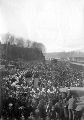
Item is a photograph showing the Strathcona Horse contingent leaving for the Boer War surrounded by crowds at the C.P.R. train tracks.
![[Spences Bridge]](/uploads/r/null/1/f/1fab92eeceb5dbfae442855dbfc163e6e5a14aebb3933465f3084b0dff05fc8c/78310f9d-0f7b-4493-8d0a-8c1d40ed6a20-A33619_142.jpg)
Part of Major Matthews collection
![[Social event during the launch of "The Canadian"]](/uploads/r/null/5/4/54d8c509b29725a0ad1dc44c7facbad8aca43366a6df8db0a01b89c41315267f/1526cc7c-a374-498a-9dbc-3a3f8df99ad1-A70847_142.jpg)
[Social event during the launch of "The Canadian"]
Part of H.A. Price collection
![[Social event during the launch of "The Canadian"]](/uploads/r/null/1/9/197454a79e6fefcf1bc565b495dc593cb0876186e8871f93e075d00d818ee8c5/ed95a43c-654f-4060-89f3-89b4ceddfdf6-A70846_142.jpg)
[Social event during the launch of "The Canadian"]
Part of H.A. Price collection
Photograph shows 4 men seated in one of "The Canadian" cars.
![Site for Pender St. Freight Sheds [Proposed CPR warehouse site]](/uploads/r/null/c/9/c98fbf881beb24751e22d4a29ef8dafbc64384308780d7650b102a840d3ec9cf/2b82a78b-d54c-4439-a722-0a91a3254cb1-A49474_142.jpg)
Site for Pender St. Freight Sheds [Proposed CPR warehouse site]
Part of H.A. Price collection
Photograph shows land near Pender and Hastings Streets. Image includes railsiding, shed, and buildings in the distance.
![[Ships docked near grain elevator]](/uploads/r/null/8/9/89a9155e00cd2af17d01c7fab30bf4b53045a673f1acdbdd73bc1a43e8d9205b/5db8bea4-91d1-4c85-95d8-95ec5091390d-A74281_142.jpg)
[Ships docked near grain elevator]
Part of James Crookall fonds

Part of City of Vancouver fonds
Item consists of two sections on one sheet. Sections show the area from Milton Street to Heather Street and Seventy-second Avenue to Fraser River (Sheet Z) ; as well as Angus Drive to Granville Street and South West Marine Drive to Fraser River (Sheet V). Includes streets, roads, railway lines, blocks, lots and legal descriptions. Section is hand coloured to show tax sale property for sale, property with no water, street widening and drainage, replotting, reserved land for schools, reserved land for parks, sundry land, capital assets not including schools and parks, schools, and parks, as applicable.
Vancouver (B.C.). Office of the City Engineer

Part of City of Vancouver Archives technical and cartographic drawing collection
Item consists of two sections. One shows the area from Milton Street to Heather Street and Seventy-second Avenue to Fraser River; the other shows Angus Drive to Granville Street and South West Marine Drive to Fraser River. Includes streets, roads, railway lines, blocks, lots and legal descriptions.
Vancouver (B.C.). Office of the City Engineer

Part of City of Vancouver Archives technical and cartographic drawing collection
Item is a sheet with two sections. The first section shows the area from Milton Street to Heather Street and Seventy-second Avenue to Fraser River; the second section shows the area from Angus Drive to Granville Street and South West Marine Drive to Fraser River. Sections show streets, roads, blocks, lots and legal descriptions, as well as the location of railway lines, the Eburne Sawmill, and a proposed bridge to Richmond.
Vancouver (B.C.). Office of the City Engineer