
Bus routings in the downtown area
- AM738-S1-: MAP 894-: LEG1256.2
- Part
- 1956
Part contains textual information about bus routes and services.
17 results with digital objects Show results with digital objects
Bus routings in the downtown area
Part contains textual information about bus routes and services.

Composite map of B.C. Electric downtown bus routes
Part shows bus routes from Burrard Inlet in the north to False Creek in the south and from Main Street in the east to Thurlow in the west.

Map of Fraser Valley ; Street map of New Westminster ; Map of Greater Vancouver transit lines
Part consists of a street map of the Lower Mainland and Fraser Valley from Vancouver to Chilliwack, a street map of New Westminster, a map showing transit lines in Greater Vancouver, and text advertising the products and services of the Dominion Map and Blueprint Company.

Transit system map of Greater Vancouver, B.C.
Part consists of a map showing trolley coach lines, bus lines, street car lines, interurban lines, interurban stops, route numbers, B.C. Electric installations and block numbers in West Vancouver, North Vancouver, Vancouver, Burnaby and the University Endowment Lands.

Transit detail inset maps ; Street index ; Transit and tourist information
Part consists of three maps showing transit details in Richmond, New Westminster and downtown Vancouver, and descriptive information about B.C. Electric routes and services and Greater Vancouver attractions.

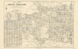
Dial map of Greater Vancouver and suburbs
Part of City of Vancouver Archives technical and cartographic drawing collection
Part contains a street map of Vancouver, Burnaby, New Westminster, West Vancouver and North Vancouver showing block numbers, street car, bus, and railway lines, parks and hospitals. Map includes two dials (a numbered circle, a paper indicator, a grid of block numbers and a street index used to find locations). A small inset map shows the Capitol Hill/Scenic Park area of Burnaby in greater detail.

Part of City of Vancouver Archives technical and cartographic drawing collection
Part contains a street map of Vancouver showing streets, block numbers, bus routes, railway lines, boundaries, private roads and hospitals. The map includes a dial (a numbered circle, a paper indicator, a grid of block numbers and a street index used to find locations in Vancouver). A small inset shows the streets surrounding Queen Elizabeth Park, which are obscured on the main map where the indicator is attached.

Map of Burnaby and New Westminster, British Columbia
Part of City of Vancouver Archives technical and cartographic drawing collection
Part consists of a street map of Burnaby and New Westminster, information on bus and street car routes, and text advertising the products and services of the Dominion Map and Blueprint Company.

Dial map of Greater Vancouver and suburbs
Part of City of Vancouver Archives technical and cartographic drawing collection
Part contains a street map of Vancouver, Burnaby, New Westminster, West Vancouver and North Vancouver showing block numbers, street car, bus, and railway lines, parks and hospitals. Map includes two dials (a numbered circle, a paper indicator, a grid of block numbers and a street index used to find locations). A small inset map shows the Capitol Hill/Scenic Park area of Burnaby in greater detail.

Dial map of Greater Vancouver and suburbs
Part contains a street map of Vancouver, Burnaby, New Westminster, West Vancouver and North Vancouver showing block numbers, street car, bus, and railway lines, parks and hospitals. Map includes two dials (a numbered circle, a paper indicator, a grid of block numbers and a street index used to find locations). A small inset map shows the Capitol Hill/Scenic Park area of Burnaby in greater detail.

Part contains a street map of Vancouver showing street car, bus and railway lines, hospitals, and block numbers. Part includes a dial (a numbered circle, a paper indicator, a grid of block numbers and a street index used to find locations).
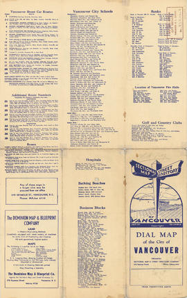
Information on transit and buildings in Vancouver
Part is the text side of a street map of Vancouver. Part also includes text advertisitng the products and services of the Dominion Map and Blueprint Company.
Part contains a street map of Vancouver showing street car, bus and railway lines, hospitals, and block numbers. Part includes a dial (a numbered circle, a paper indicator, a grid of block numbers and a street index used to find locations).

Street index (Gibson Street to William Street) and tram stations
Part of City of Vancouver Archives technical and cartographic drawing collection
Part is a page from the booklet accompanying a guide map of Greater Vancouver, and contains the last portion of the North Vancouver street index, the West Vancouver street index, and a list of Vancouver tram stations.

Part of City of Vancouver Archives technical and cartographic drawing collection
Part is a map showing Vancouver including Point Grey, Hastings Townsite, and part of South Vancouver. Map shows streets, street car routes, neighbourhoods, and distances from City Hall.

What the man who comes to Vancouver wants to know
Part of City of Vancouver Archives technical and cartographic drawing collection
Part contains information on lodging, restaurants, transit, social clubs, and other points of interest in Vancouver.