Showing 14 results

Archival description
City of Vancouver Archives technical and cartographic drawing collection Nautical charts
Print preview View:

13 results with digital objects Show results with digital objects

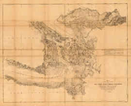
Map showing the line of boundary between the United States and British possessions

Item is a map showing four proposed boundaries between the United States and British possessions in the Salish Sea region. The explanations of the lines read in part: "[1] Boundary line contemplated by the Treaty as shown by contemporaneous evidence; [2] Boundary line as claimed by the British Commissioner; [3] Boundary line proposed by the British Commissioner as a compromise ( . . . ); [4] Boundary line in accordance with the strict letter of the Treaty ( . . . ). Item also shows soundings, and the "track of steamers plying between Victoria and Fraser river since discovery of gold."
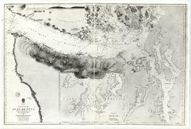
Fraser River to north east point of Texada Island : including Howe Sound and Jervis Inlet

Item is a nautical chart depicting the southern portion of the Strait of Georgia. Land shown includes (south to north): Gulf Islands, Vancouver Island to Nanoose Harbour, Vancouver area, Bowen Island, Gambier Island, Howe Sound, Seechelt Peninsula, and north to Queen's Reach. Inset map is of Tucker Bay on Lasqueti Island. The illustrations are of Georgina Point Lighthouse, Active Pass and the north shore of Gabriola Island.

Howe Sound and Howe Sound (southern portion)

Item contains two nautical charts of Howe Sound; one chart shows the southern portion (Bowen Island and Gambier Island) only, while the other shows the Sound from Burrard Inlet in the south to Squamish in the north. Charts show soundings in fathoms, tidal information, bench marks, locations of cables, and characteristics of land at shorelines.

Vancouver Harbour : Sheet 2 (Point Grey to Second Narrows)

item is a nautical chart of Burrard Inlet and Vancouver Harbour from Point Grey in the west to Second Narrows in the east, showing soundings in fathoms, tidal information, anchorages, beacons, and waterfront businesses. Street names are shown on land areas. A Royal Canadian Air Force bombing range at Jericho Beach is identified as a danger area.