
Lower Mainland, B.C. : land subdivision
- AM1594-: MAP 537
- Item
- [1870?], copied [197-?]
Part of City of Vancouver Archives technical and cartographic drawing collection
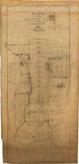
Item is a copy of a manuscript map showing portions of land surrounding Burrard Inlet, Second Narrows and Port Moody, and the boundaries of lots. The lots are labelled with the owner's name, or marked as reserve land or land not yet sold.

![[Vancouver, B.C. : district lots]](/uploads/r/null/4/a/4a5c15633319c3754d3aa0cc525470bfebcf5a98ad8caeedf44b777194f300bd/2f055d65-47f7-4679-bb91-66b8f1843d2f-MAP531_142.jpg)


![Canadian Pacific map of Vancouver [west half]](/uploads/r/null/f/a/fa49266d21715d75ce93883012d471657dd058b90843927ec82b44d2bb42b007/f12ea9a5-4914-4db8-bda9-312aa2e2ccef-MAP10_142.jpg)


![Map of the business portion of the City of Vancouver, British Columbia [early street paving]](/uploads/r/null/7/1/7187f671d2770050eb87f7f397a10ea92bf0bc593b0a186e3a4bf341b3d26e42/8770145a-b925-4eef-82ac-e397f61a65aa-Map1163_142.jpg)
![Municipality of North Vancouver [Burrard Inlet]](/uploads/r/null/6/d/6d0d9a4b75b38672c56aa89a5984fe2d0e6d66be85f6f375cbe8e2fd7ac94a98/577914e1-3de2-478b-a629-5f391731387a-MAP588_142.jpg)


![Plan of town of Lonsdale : situate [sic] on harbour opposite City of Vancouver](/uploads/r/null/c/5/d/c5d4b56db1d7f9e1cf57dd5a974f6fcb23507e64543bad1bdd8f62139042389f/1cc57eaf-6c92-438e-a65d-335940738df7-MAP686_142.jpg)


