Title and statement of responsibility area
Title proper
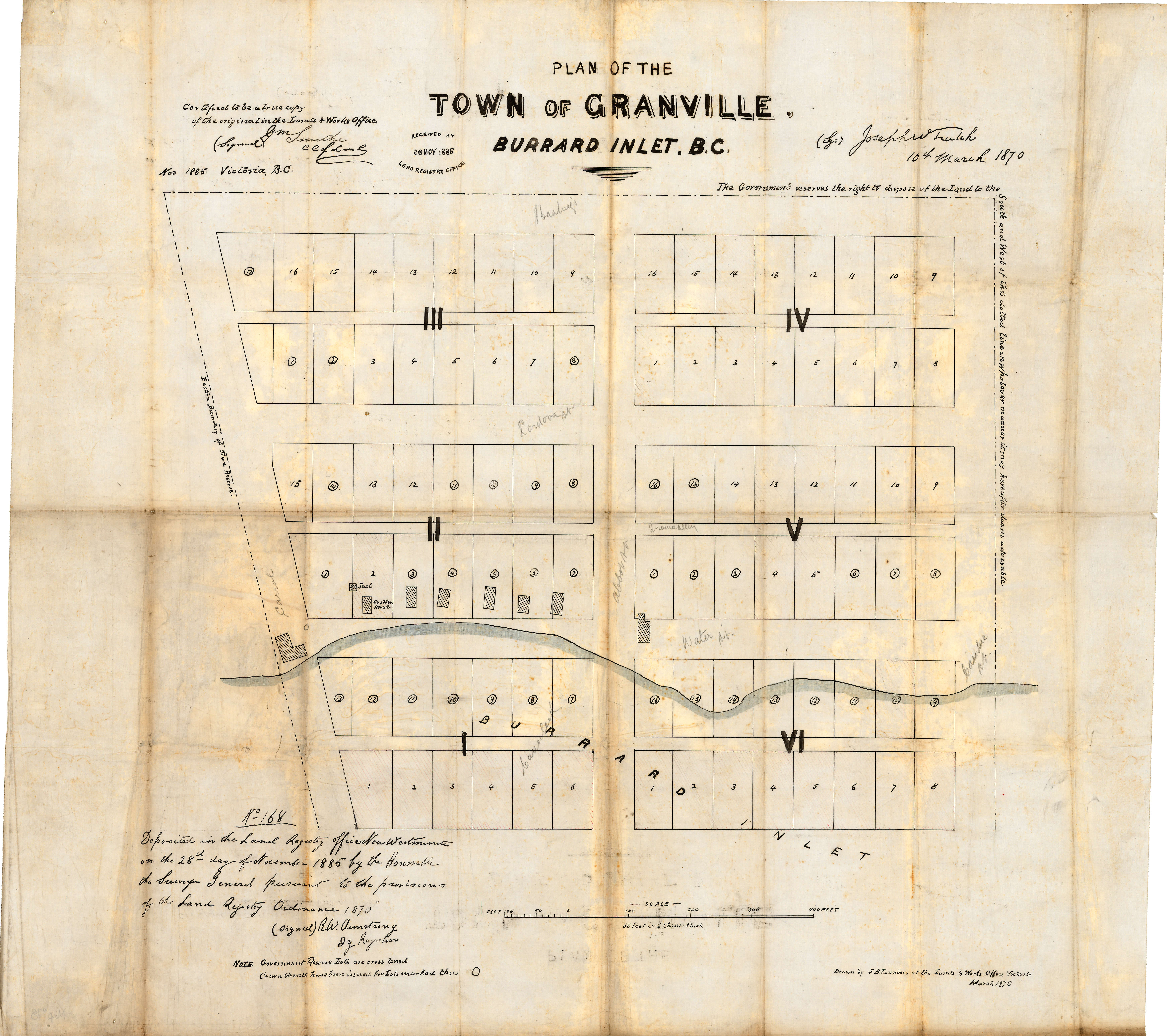
Plan of the town of Granville, Burrard Inlet, B.C.
General material designation
- Cartographic material
Parallel title
Other title information
Title statements of responsibility
Title notes
Level of description
Item
Reference code
Edition area
Edition statement
Edition statement of responsibility
Class of material specific details area
Statement of scale (cartographic)
Scale [1:792]
Statement of projection (cartographic)
Statement of coordinates (cartographic)
Statement of scale (architectural)
Issuing jurisdiction and denomination (philatelic)
Dates of creation area
Date(s)
-
Mar. 1870 (traced 1885) (Creation)
- Creator
- British Columbia. Department of Lands and Works
- Note
- Map traced from the 1885 tracing of the original 1870 map.
Physical description area
Physical description
1 map : ink on paper ; 60 x 62 cm
Publisher's series area
Title proper of publisher's series
Parallel titles of publisher's series
Other title information of publisher's series
Statement of responsibility relating to publisher's series
Numbering within publisher's series
Note on publisher's series
Archival description area
Name of creator
Administrative history
Custodial history
Scope and content
Item is a map of the Town of Granville, Burrard Inlet, B.C., including the area north of Hastings Street between Cambie and Carrall streets, including lots designated for what became fill lands north of Water Street. Crown grants and government reserve lots are noted.
This map is a tracing made at an undetermined date of an 1885 tracing (attested by the Chief Commissioner of Lands in Nov. 1885) of the original 1870 map attested by Joseph Trutch. The 1885 tracing, from which this map was made, had been deposited with the Land Registry Office in 1885.
Note that map is oriented to the south.
Notes area
Physical condition
Some yellowing, creases, and ink transfer where the map was folded.
Immediate source of acquisition
Arrangement
Map had previously been alienated from its original fonds and placed in AM1594.
Language of material
Script of material
Location of originals
Availability of other formats
A digitized copy of this item is available on-line.
Restrictions on access
Terms governing use, reproduction, and publication
Finding aids
Associated materials
Accruals
General note
In the AM54-S13 inventory, was part of Oblong S.37.
External Link
ftp://webftp.vancouver.ca/archives/MAPS-TIFF/MAP978.tif
Format: TIFF (LZW compressed)
MD5: D0D38784EE4E8940198AC44AA79BBE2E
*Size: 66174692 bytes
Rights
Public domain
Alternative identifier(s)
Standard number area
Standard number
Access points
Subject access points
Place access points
Name access points
- Launders, J.B. (Author)