Print preview Close

Showing 119 results

Archival description
Vancouver (B.C.) Land subdivision Image With digital objects
Print preview View:

Canadian Pacific Railway. Plan of part of branch line from Port Moody. A point on main line C.P.R. to English Bay, B.C.

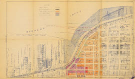
Map shows a survey conducted by the Canadian Pacific Railway of English Bay, Burrard Inlet and Coal Harbour, including a rough outline of area and lots. Note on map reads "Certified as a correct plan showing the land required for right of way Burrard Inlet B.C., February 22, 1886. H.J. Cambie, Engineer in Charge." Map is certified as correct and signed by various C.P.R. officials, including W.C. Van Horne.

City of Vancouver : Canadian Pacific town site

Part contains four maps. The main map shows district lots and block numbers in Vancouver from Vine Street in the west to Boundary Avenue (Glen Drive) in the east and Stanley Park in the north to 9th Avenue (Broadway) in the south. Three smaller maps include an index plan to district lots in Vancouver, South Vancouver, New Westminster, and Burnaby; a world map showing Canadian Pacific mail steamship lines; and an index plan of Vancouver city limits. Part has been annotated with text describing a June 1888 land clearance plan and hand colouring indicating clearance status.

City of Vancouver : Canadian Pacific town site

Item is a map showing lot numbers and street names in Vancouver's West End from Boundary Avenue (now Glen Drive) in the east to Chilco Street in the west and Kitsilano (from First Avenue in the north to Fifth Avenue in the south and from Heather Street in the east to Vine Street in the west). The three inset maps are a map of "Canadian Pacific mail steamship lines" around the world, an "Index plan of Vancouver, B.C." and an "Index plan city limits".

City of Vancouver : Canadian Pacific town site

Part contains four maps. The main map shows district lots and block numbers in Vancouver from Vine Street in the west to Boundary Avenue (Glen Drive) in the east and Stanley Park in the north to 9th Avenue (Broadway) in the south. Three smaller maps include an index plan to district lots in Vancouver, South Vancouver, New Westminster, and Burnaby; a world map showing Canadian Pacific mail steamship lines; and an index plan of Vancouver city limits.

Map of Granville Street, downtown Vancouver

Item is a map showing Granville Street from the Granville Street Bridge over False Creek in the southwest to the train yard and waterfront below Cordova Street in the northeast. Numbered city blocks on either side of the street are depicted, with numbers and occupants' names (including businesses) shown for most of the properties. The location of the publisher's office on Seymour Street is shown.

Plan of Greater Vancouver, British Columbia

Item is a map of Greater Vancouver from Alma Road (Alma Street) to Boundary Road and Burrard Inlet to King Edward Avenue. Map shows district lot, block, and lot numbers, waterfront businesses, rail lines, schools, parks, beaches, and concentric circles indicating distances from a point located approximately at the intersection of Cambie and Hastings Streets.

Plan of provincial government property being a portion of townsite of Vancouver and sub-division of lot 540, group 1, New Westminster District, B.C., to be sold by public auction at Vancouver, B.C.

Item is a map showing lot numbers, lot boundaries, major streets and property sold or reserved in the area bounded by Campbell Street (Alma Street), present-day Trafalgar Street (unnamed on map), English Bay, and 16th Avenue.

Plan of re-subdivision of lots 3 to 14, subn [subdivision] 2 of bk [block] 3. D.L. 391 & 392

Map shows the subdivision of lots in the block bordered by 31st Avenue East, 32nd Avenue East, St. Catherines Street and Windsor Street, at that time in the District of South Vancouver. Map is certified by the surveyor Arthur H. Holland, British Columbia Land Surveyor, and W.A. Pound, Reeve of the District of South Vancouver. It is unclear as to whether the map was commissioned by the Corporation of the District of South Vancouver.

Plan of the City of Vancouver

Item is a reduced size copy of the Hermon & Burwell map Plan of the City of Vancouver. This copy is ca. 1/4 the size of the original map. The map shows District Lots, blocks and lots; transportation infrastructure such as bridges and railway and streetcar lines; and the identification of some industries, especially along the various waterfronts.

Results 1 to 50 of 119