![Plate 114 [Quebec Street to Fifth Avenue to Manitoba Street to Eighth Avenue]](/uploads/r/null/1/d/a/1da8c667b11d0f463073015a74cdc6f409f2f18733a36abda9afe0b996d9abe6/02c6dfe0-25c2-4696-8ff5-429480c2de74-1974-100_142.jpg)
Plate 114 [Quebec Street to Fifth Avenue to Manitoba Street to Eighth Avenue]
- AM1594-MAP 625-: 1974-100.18
- Item
- Sept. 1905
Part of City of Vancouver Archives technical and cartographic drawing collection
1440 results with digital objects Show results with digital objects
Plate 114 [Quebec Street to Fifth Avenue to Manitoba Street to Eighth Avenue]
Part of City of Vancouver Archives technical and cartographic drawing collection
![Plate 120 [Manitoba Street to Eighth Avenue to Alberta Street to Eleventh Avenue]](/uploads/r/null/f/a/6/fa6302e459598f703ec9a4f6d49de458a312194cf71a4d02ffaeb7416336e184/73a06efd-6ff6-4712-86d3-99cef6e5d4f3-1974-100_142.jpg)
Plate 120 [Manitoba Street to Eighth Avenue to Alberta Street to Eleventh Avenue]
Part of City of Vancouver Archives technical and cartographic drawing collection
![Plate 126 [Block east of Westminster Road, to Eleventh Avenue to Quebec Street to Fourteenth Avenue]](/uploads/r/null/c/f/c/cfc0873d3a7b7370676e1fe47a0b3d7a1c1548fcc9f956684126904f28b3eab1/90c52799-da7f-49d6-8ea9-96653757bd78-1974-100_142.jpg)
Plate 126 [Block east of Westminster Road, to Eleventh Avenue to Quebec Street to Fourteenth Avenue]
Part of City of Vancouver Archives technical and cartographic drawing collection
![Plate 127 [Victoria Drive to Eleventh Avenue to Sophia Street to Fourteenth Avenue]](/uploads/r/null/8/0/1/8015ddcd6ee093727af89d8411f527c5942313bf9477353bf2cb54ffde758a42/ec3257e4-b725-430e-9f32-98e02e541fc9-1974-100_142.jpg)
Plate 127 [Victoria Drive to Eleventh Avenue to Sophia Street to Fourteenth Avenue]
Part of City of Vancouver Archives technical and cartographic drawing collection

Part of City of Vancouver Archives technical and cartographic drawing collection
![Plate 139 [Cedar Street to York Street to block west of Cypress Street to Third Avenue]](/uploads/r/null/1/6/8/16834cc0833e75a965d75cb28e98aed82386baa4a3dd16adfb2214fb7784e6de/996a3797-d9a1-4d7e-85ec-026ef449eb72-1974-100_142.jpg)
Plate 139 [Cedar Street to York Street to block west of Cypress Street to Third Avenue]
Part of City of Vancouver Archives technical and cartographic drawing collection
![Plate 145 [Pine Street to Third Avenue to block west of Cedar Street to Sixth Avenue]](/uploads/r/null/6/e/d/6edf28481ccf2f8c292cafc7d295d8dc5f0f8a4df775363d1a834454503f7457/054c1f34-de8e-4f3c-95c6-cd44be0a9257-1974-100_142.jpg)
Plate 145 [Pine Street to Third Avenue to block west of Cedar Street to Sixth Avenue]
Part of City of Vancouver Archives technical and cartographic drawing collection
![Plate 148 [Yew Street to Sixth Avenue to Vine Street to Ninth Avenue]](/uploads/r/null/1/6/d/16d2ce9f2af7c7c7d0e0d3b10d0236d78460c38de3f1503704b5af9f8b1c1577/b8c5b1ec-4d07-415e-b3c6-fb3fda7febbc-1974-100_142.jpg)
Plate 148 [Yew Street to Sixth Avenue to Vine Street to Ninth Avenue]
Part of City of Vancouver Archives technical and cartographic drawing collection
![Plate 153 [Hemlock Street to Sixth Avenue to block west of Granville Street to Ninth Avenue]](/uploads/r/null/0/a/b/0abee4f6ab9261fdd6d4c93bc35e4a02bc8fdc3f6b17439c7a8d92cd560ff491/09319ade-296b-4282-bb2c-e7963da06d6d-1974-100_142.jpg)
Plate 153 [Hemlock Street to Sixth Avenue to block west of Granville Street to Ninth Avenue]
Part of City of Vancouver Archives technical and cartographic drawing collection
![Plate 159 [Bridge Street to Sixth Avenue to block west of Ash Street to Ninth Avenue]](/uploads/r/null/e/4/4/e44f57cba6b38fa8da6ef44cbb61be076fcf20c0156c0ae088cd88ac1c2d7de9/41ef2962-f94b-4a03-853d-b6e743b5c09f-1974-100_142.jpg)
Plate 159 [Bridge Street to Sixth Avenue to block west of Ash Street to Ninth Avenue]
Part of City of Vancouver Archives technical and cartographic drawing collection
![Plate 162 [Bridge Street to Fourteenth Avenue to Heather Street to Seventeenth Avenue]](/uploads/r/null/5/2/5/5256cff8242defeed25de4521f059690bd7ac034661f9e0b1d3a1d3531ed3d68/6f5bb597-8fce-40e1-bc4f-2ec474b293f1-1974-100_142.jpg)
Plate 162 [Bridge Street to Fourteenth Avenue to Heather Street to Seventeenth Avenue]
Part of City of Vancouver Archives technical and cartographic drawing collection
Insurance plan of Vancouver, British Columbia. Volume two
Part of City of Vancouver Archives technical and cartographic drawing collection
Item is the second volume of a fire insurance plan incorporating the "old" City of Vancouver south of False Creek only, and the City of North Vancouver. The volume includes key plans for each city, as well as an index of streets and blocks for Vancouver.

Index to streets and block numbers
Part of City of Vancouver Archives technical and cartographic drawing collection
![Plate 106 [Manitoba Street to Dufferin Street to Alberta Street to Fifth Avenue]](/uploads/r/null/a/2/8/a288bcdc881a84d269c058cb38c117c43ef34c68d4a36dd1ffa72bfc2a46ba60/2d5baff6-456c-4406-9faf-fdd562e492b0-1974-100_142.jpg)
Plate 106 [Manitoba Street to Dufferin Street to Alberta Street to Fifth Avenue]
Part of City of Vancouver Archives technical and cartographic drawing collection
![Plate 115 [Scotia Street to Fifth Avenue to Quebec Street to Eighth Avenue]](/uploads/r/null/b/8/6/b86c99928da0cefb46e6dc6e7d9b2f9feb0c5d75b13cbfacf0da89c0e212870c/10e20065-c9ef-41ad-a820-8e3c418d2043-1974-100_142.jpg)
Plate 115 [Scotia Street to Fifth Avenue to Quebec Street to Eighth Avenue]
Part of City of Vancouver Archives technical and cartographic drawing collection
![Plate 117 [Carolina Street to Seventh Avenue to Victoria Drive to Tenth Avenue]](/uploads/r/null/f/0/1/f01e37963864f5231283cc4e6bc7df6cd6d6df44667846c5e69dc6787c623881/1797e915-b1a7-4980-acf1-b42faefa128c-1974-100_142.jpg)
Plate 117 [Carolina Street to Seventh Avenue to Victoria Drive to Tenth Avenue]
Part of City of Vancouver Archives technical and cartographic drawing collection
![Plate 138 [Block east of Maple Street to York Street to Arbutus Street to Third Avenue]](/uploads/r/null/6/9/2/692f296ac23d1ac9b6172d0c655bd72dab24b5d54f685fe841fee63caf544f0d/1d2fa9e3-9b76-4de1-93ae-5ab487d1eee6-1974-100_142.jpg)
Plate 138 [Block east of Maple Street to York Street to Arbutus Street to Third Avenue]
Part of City of Vancouver Archives technical and cartographic drawing collection
![Plate 143 [Maple Street to Third Avenue to block west of Arbutus Street to Sixth Avenue]](/uploads/r/null/0/e/a/0ea98fd76cb501aabd4ab7f104a05849e09062d7e588acf3aed4242cf3e622b8/6d85924e-f159-40bc-95ae-6c991ff3b2c9-1974-100_142.jpg)
Plate 143 [Maple Street to Third Avenue to block west of Arbutus Street to Sixth Avenue]
Part of City of Vancouver Archives technical and cartographic drawing collection
![Plate 146 [Block east of Fir Street to Third Avenue to Pine Street to Sixth Avenue]](/uploads/r/null/f/5/f/f5f0590ecf8724bfa6c9f2bcff56c118991a327bd55de2e5ce81b9a5dd964194/a512e8de-7c29-40ef-8a86-92ec8f6717bb-1974-100_142.jpg)
Plate 146 [Block east of Fir Street to Third Avenue to Pine Street to Sixth Avenue]
Part of City of Vancouver Archives technical and cartographic drawing collection
![Plate 147 [Hemlock Street to False Creek to block west of Granville Street to Sixth Avenue]](/uploads/r/null/a/b/d/abd13a3749032aa33979a67cba7062ed3cf112839e13bafb0eee601ec40fc955/30faa6e3-9576-4383-9326-89c314adf9cd-1974-100_142.jpg)
Plate 147 [Hemlock Street to False Creek to block west of Granville Street to Sixth Avenue]
Part of City of Vancouver Archives technical and cartographic drawing collection
![Plate 152 [Block east of Fir Street to Sixth Avenue to Pine Street to Ninth Avenue]](/uploads/r/null/9/3/6/93607ace79536cc9ba73482f1f25a28f8b7cd33c40d6117463d7190a5cd58cab/33eb584e-3f39-41a1-adb0-c3d2f0a2ef0b-1974-100_142.jpg)
Plate 152 [Block east of Fir Street to Sixth Avenue to Pine Street to Ninth Avenue]
Part of City of Vancouver Archives technical and cartographic drawing collection
![Plate 156 [Block east of Oak Street to Sixth Avenue to Spruce Street to Ninth Avenue]](/uploads/r/null/f/8/1/f81307f079a5ed18bb6e49affd7a5f3d3100e9ba3238d592691d04ffeda95499/cad8edde-d5d0-4c5c-b0f8-93ec688a9cb6-1974-100_142.jpg)
Plate 156 [Block east of Oak Street to Sixth Avenue to Spruce Street to Ninth Avenue]
Part of City of Vancouver Archives technical and cartographic drawing collection

Part of City of Vancouver Archives technical and cartographic drawing collection
Item is a map showing lot numbers, lot boundaries, major streets and property sold or reserved in the area bounded by Campbell Street (Alma Street), present-day Trafalgar Street (unnamed on map), English Bay, and 16th Avenue.

Plan of part of sub-division of district lot 540, South Vancouver, provincial government property
Part of City of Vancouver Archives technical and cartographic drawing collection
Item is a map showing district lot, block, and lot numbers of properties for sale in the area bounded by Blanca Street, Campbell Street (Alma Street), English Bay, and 16th Avenue. Sold or reserved properties are marked in red.

Part of City of Vancouver Archives technical and cartographic drawing collection
Item is a map showing major landmarks, railway lines, harbour lands reclaimed, proposed wharves and piers, retaining walls and dredging, and soundings in fathoms in Vancouver Harbour (Burrard Inlet) and False Creek.
Plan of False Creek, Vancouver, B.C.
Part of City of Vancouver Archives technical and cartographic drawing collection
Map shows streets, railways, land to be reclaimed, foreshore applied for, foreshore granted by order in council, proposed wharf lines, areas to be dredged and land ownership in and along False Creek. A key map in the top right-hand corner shows the location of False Creek in relation to the rest of Vancouver.

Part of City of Vancouver Archives technical and cartographic drawing collection
Item is a map showing lot numbers, lot boundaries and property sold or reserved northwest of Capilano Creek along the north shore of Burrard Inlet. The map does not include street names.

Part of City of Vancouver Archives technical and cartographic drawing collection
Item is a map showing major streets, lot numbers, lot boundaries and property sold or reserved in the area from Chaldecott Road (now King Edward Ave.) in the north to Magee Road (now W. 49th Ave.) in the south. Kaye Road (now Trafalgar St.), Wilson Road (now W. 41 Ave.), Bodwell Road (now W. 33rd Ave.) and Johnson Road (now Blenheim) are all included on the map.
Map of portion of New Westminster District with adjacent islands and part of Vancouver Island
Part of City of Vancouver Archives technical and cartographic drawing collection
Item is a property map which shows timber leasesholds, Indian reserves, districts, and parcels of land.

Index plan of provincial government lands to be sold at auction at Vancouver B.C. November 20, 1906
Part of City of Vancouver Archives technical and cartographic drawing collection
Item is a map showing lots owned by the provincial government to be sold at auction. Lots are located in North Vancouver, Vancouver, South Vancouver, Hastings Townsite and Burnaby.

Part of City of Vancouver Archives technical and cartographic drawing collection
Part contains a map of East Vancouver Heights showing streets, block numbers and lot numbers, an index map showing the location of East Vancouver Heights in relation to the rest of the city, and text promoting the area.
Plan of the City of Vancouver, British Columbia
Part of City of Vancouver Archives technical and cartographic drawing collection
Item is a map sheet with two maps of Vancouver. The main map shows District Lots, blocks and ranges of lot numbers, streets, railway lines, and boundaries in Vancouver. The inset map shows Stanley Park with rough depictions of topography.

Part of City of Vancouver Archives technical and cartographic drawing collection
Part is the right-hand half of a map sheet that has been mounted onto linen. The sheet shows Vancouver streets, District Lots, blocks and lots as well as main city infrastructure from Willow Street to the eastern edge of the City.
Part of City of Vancouver Archives technical and cartographic drawing collection
Item is an advertisement for real estate in East Vancouver Heights, with a map of the subdivision and promotional text on one side and an illustrated oblique view of Vancouver on the other.
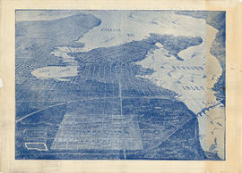
Bird's eye view of Vancouver, B.C.
Part of City of Vancouver Archives technical and cartographic drawing collection
Part contains an illustrated oblique view of Vancouver showing steamship lines, bridges, beaches, major roads, and the location and block numbers of East Vancouver Heights.

Part of City of Vancouver Archives technical and cartographic drawing collection
Part is the left-hand half of a map sheet that has been mounted onto linen. The sheet shows Vancouver streets, District Lots, blocks and lots as well as main city infrastructure from the western edge of the City east to Willow Street. The inset map shows Stanley Park.
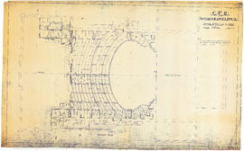
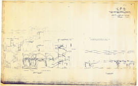
CPR Vancouver Opera House ground floor plan
Part of City of Vancouver Archives technical and cartographic drawing collection
Item is an architectural drawing of the first Vancouver Opera House. The drawing appears to be of the design of renovations to the original structure.
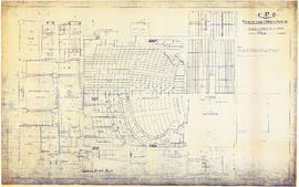
CPR Vancouver Opera House balcony plan
Part of City of Vancouver Archives technical and cartographic drawing collection
Item is an architectural drawing of the first Vancouver Opera House. The drawing appears to be of the design of renovations to the original structure.
![CPR Vancouver Opera House elevation to Farrell apartment building [south]](/uploads/r/null/a/5/d/a5d0b51f5ebdb12f52ebe4d7b4789fdeba6d42de6c545267e9cc245f6f760007/f58c68f3-d53f-4433-b4a9-9e9510f429c5-1989-20_142.jpg)
CPR Vancouver Opera House elevation to Farrell apartment building [south]
Part of City of Vancouver Archives technical and cartographic drawing collection
Item is an architectural drawing of the first Vancouver Opera House. The drawing appears to be of the design of renovations to the original structure.

CPR Vancouver Opera House Gallery plan, ceiling plan and section
Part of City of Vancouver Archives technical and cartographic drawing collection
Item is an architectural drawing of the first Vancouver Opera House. The drawing appears to be of the design of renovations to the original structure.
![CPR Vancouver Opera House elevation to hotel [north]](/uploads/r/null/f/d/3/fd36e9463c257d654596ac0175eda976e793e46e728364441848badc37ba1faf/cd3849c0-8d60-4452-a85c-b4457d6509b1-1989-20_142.jpg)
CPR Vancouver Opera House elevation to hotel [north]
Part of City of Vancouver Archives technical and cartographic drawing collection
Item is an architectural drawing of the first Vancouver Opera House. The drawing appears to be of the design of renovations to the original structure.
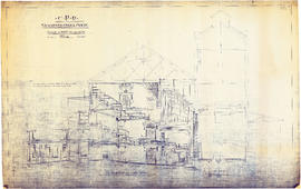
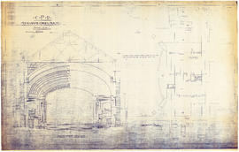
CPR Vancouver Opera House longitudinal section
Part of City of Vancouver Archives technical and cartographic drawing collection
Item is an architectural drawing of the first Vancouver Opera House. The drawing appears to be of the design of renovations to the original structure.
CPR Vancouver Opera House sections A-A and B-B
Part of City of Vancouver Archives technical and cartographic drawing collection
Item is an architectural drawing of the first Vancouver Opera House. The drawing appears to be of the design of renovations to the original structure.
CPR Vancouver Opera House transverse section and basement plan
Part of City of Vancouver Archives technical and cartographic drawing collection
Item is an architectural drawing of the first Vancouver Opera House. The drawing appears to be of the design of renovations to the original structure.

CPR Vancouver Opera House trusses for gallery and balcony
Part of City of Vancouver Archives technical and cartographic drawing collection
Item is an architectural drawing of the first Vancouver Opera House. The drawing appears to be of the design of renovations to the original structure.

Plan of the City of Vancouver, British Columbia
Part of City of Vancouver Archives technical and cartographic drawing collection
Item is a partial copy of a map of Vancouver, showing only the western portion of the pre-1929 city.

The Municipality of South Vancouver
Part of City of Vancouver Archives technical and cartographic drawing collection
Item is a map depicting the Municipality of South Vancouver. The map has been annotated to indicate some of the routes of BC Electric Railway street car lines and surveyed extensions.
Plan of Point Grey municipality
Part of City of Vancouver Archives technical and cartographic drawing collection
Item is a map showing district lot boundaries and land subdivision for the municipality of Point Grey. Electric lines and proposed electric lines are also shown.
Part of City of Vancouver Archives technical and cartographic drawing collection
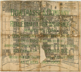
Item is a map used as an advertisement for Dow, Fraser & Co. Limited, Real Estate and Fire Insurance. The map portion of the design is taken from a map published by Archibald Moir & Co. (see MAP 73).

Map of the south-western part of British Columbia
Part of City of Vancouver Archives technical and cartographic drawing collection
Item is a map which depicts the relative locations of various Land Districts and Divisions in south-west British Columbia. The boundaries between the districts are not shown. The map also shows physical features (though not topography) and transportation routes.