
View on park road, near English Bay
- AM54-S4-: SGN 98
- Item
- [1889?]
Part of Major Matthews collection
Photograph shows men with horsedrawn carriage on dirt road surrounded by trees and bush. J.S. Matthews' notes with print or negative in Archives.
141 results with digital objects Show results with digital objects
View on park road, near English Bay
Part of Major Matthews collection
Photograph shows men with horsedrawn carriage on dirt road surrounded by trees and bush. J.S. Matthews' notes with print or negative in Archives.
![[Two women standing on dirt road at Brockton Point], Stanley Park, Vancouver, B.C.](/uploads/r/null/1/9/19c490cb9966c5e557122e85919e66c5b45e9efcdd0a79eb97fe8e189a6fc039/d0478418-e83e-4b60-8975-9452a792bab5-A04011_142.jpg)
[Two women standing on dirt road at Brockton Point], Stanley Park, Vancouver, B.C.
Part of Major Matthews collection
J.S. Matthews' notes with print or negative in Archives.

Rustic bridge on Stanley Park Road, Vancouver, B.C.
Part of Major Matthews collection
J.S. Matthews' notes with print or negative in Archives.

Autumn in Stanley Park, Vancouver, B.C.
Part of Major Matthews collection
Photograph shows three men in a carriage on a dirt road surrounded by trees and bush. J.S. Matthews' notes with print or negative in Archives.
![[Logging skid trail in Stanley Park]](/uploads/r/null/c/8/c85475e830cbbc0ebe0a968b70a19732b55884211ee1afd17251089afb598512/c3018567-504e-44ab-9e6c-57be58d7bd4f-A32019_142.jpg)
[Logging skid trail in Stanley Park]
Part of Major Matthews collection

Souvenir of Stanley Park, Vancouver, B.C.
Part of Major Matthews collection
Photograph shows scenes including: Brockton Point, Siwash Rock, Park Drive and the Giant Cedar (Hollow Tree)
![[Family assembled on rock near road in Stanley Park]](/uploads/r/null/8/9/8914c49e2fceccc98b108f67b279ccc659ceaae8d7cbdddeed75a302a11b97f9/e655abfd-ad9f-4feb-9348-21964cba3e18-A04019_142.jpg)
[Family assembled on rock near road in Stanley Park]
Part of Major Matthews collection
![[Family in horse drawn carriage at Stanley Park]](/uploads/r/null/0/6/06c1e5e35b964b9f95f328c3b2a4731cf5f2c0c2b72612c74bbbf2aa3cdb33be/da30dd89-7190-4819-8edc-153bd2c1ac82-A04020_142.jpg)
[Family in horse drawn carriage at Stanley Park]
Part of Major Matthews collection
J.S. Matthews' notes with print or negative in Archives.
![[Woman standing on path] Stanley Park, Vancouver, B.C.](/uploads/r/null/e/f/ef88f6091a23e7328c8e48a8b0ed56ac4353ec06cd2bc4b954102aa77926bc9d/459a380b-894a-4ca4-aa24-5cdb1ac6e740-A04015_142.jpg)
[Woman standing on path] Stanley Park, Vancouver, B.C.
Part of Major Matthews collection
Photograph shows a mounted photograph, surrounded by flowers.

Souvenir of Stanley Park, Vancouver, B.C.
Part of Major Matthews collection
Photograph consists of various images of Stanley Park, including Brockton Point, Siwash Rock, the Hollow Tree, and Park Drive. J.S. Matthews' notes with print or negative in Archives.
![[Road in Stanley Park near Brockton Point]](/uploads/r/null/b/8/b8aa1a0c165756c09f317fff3916a8de1c5a7036f11387056b17247f83a4983b/d7d67379-3251-4974-9daa-e9ffde35d2b7-A04022_142.jpg)
[Road in Stanley Park near Brockton Point]
Part of Major Matthews collection
![[Arch at entrance to Stanley Park]](/uploads/r/null/1/3/131bc813b53c435c26b494c0e2e1587b7842afdcc77d58c199c753065c5c9b9e/40346c2d-01f6-475b-98af-cc918d7442bc-A08357_142.jpg)
[Arch at entrance to Stanley Park]
Part of Major Matthews collection
Photograph shows a man standing under the arch in front of the bridge into Stanley Park.
![[Arch at entrance to Stanley Park]](/uploads/r/null/5/0/509bcab6a15d1cdd4cb67722e008d6b74106daf2c050ce28008e9a7e7631a6ed/879f45a1-17ee-4bfe-979a-a99c52c9cd8e-A36752_142.jpg)
[Arch at entrance to Stanley Park]
Part of Major Matthews collection
Photograph shows a man standing under the arch in front of the bridge into Stanley Park.
![[Brockton Point, part of village in Stanley Park, viewed from Burrard Inlet]](/uploads/r/null/e/0/e01326d91bf7be41525b652a17f95813db39bfd8f1a61dd0aba89ba2542c5617/c975de0b-8d0f-428f-b17b-51b9abb18afb-A04010_142.jpg)
[Brockton Point, part of village in Stanley Park, viewed from Burrard Inlet]
Part of Major Matthews collection
J.S. Matthews' notes with print or negative in Archives.
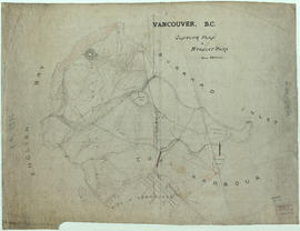
Part of City of Vancouver fonds
Item is a topographical map of Stanley Park showing various landmarks and locations of buildings.
Vancouver (B.C.). Engineer's Office
![[Woman on path at Brockton Point] Stanley Park, Vancouver, B.C.](/uploads/r/null/5/0/502014bde480027c6c971f06a7ba5782198be8cd870d41d923f08d60cab6d080/fcec5119-a5d6-44fc-9eeb-7f5918a72a9b-A04012_142.jpg)
[Woman on path at Brockton Point] Stanley Park, Vancouver, B.C.
Part of Major Matthews collection
J.S. Matthews' notes with print or negative in Archives.

Snow scene in Stanley Park, 1901, Vancouver, B.C.
Part of Richard H. Trueman fonds
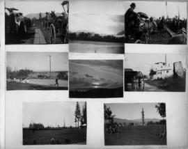
Part of Olga Jenkinson Bell fonds
Item is a page from an album with photographs showing scenes from Stanley Park, including Brockton Point grounds, views of the ocean and sky from Stanley Park and horse drawn carriages in the park.
![[View of shoreline at Stanley] Park](/uploads/r/null/6/2/6/6263842d3ef32c743064410b1ec3929a2833ff0eec4fd6dff9d05d9ead0bf978/271abf98-fd80-4892-be20-b448715e4b4a-CVA242-10_142.jpg)
[View of shoreline at Stanley] Park
Part of Olga Jenkinson Bell fonds

Stanley Park, Mr. and Mrs. Williams
Part of Olga Jenkinson Bell fonds
Item is a photograph showing Mr. and Mrs. Williams seated in Stanley Park.
![[View of dwellings at Stanley] Park](/uploads/r/null/2/9/e/29ec04e6459895cc0abee8124de12b8ae8425e580b7153a7b81b221820c3104e/78ff7b63-34d1-41a6-b4a2-9688fea52f6f-CVA242-10_142.jpg)
[View of dwellings at Stanley] Park
Part of Olga Jenkinson Bell fonds

Views of the West End, Stanley Park and English Bay
Part of Olga Jenkinson Bell fonds
Item is a page from an album with photographs showing views of the West End, Stanley Park and English Bay.
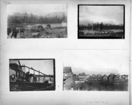
Views of the West End, Stanley Park and English Bay
Part of Olga Jenkinson Bell fonds
Item is a page from an album with photographs showing views of the West End, Stanley Park and English Bay.

Looking over Brockton Point in Stanley Park, from C.P.R. Hotel Vancouver, B.C.
Part of William Orson Banfield fonds

Photograph shows building and bridge

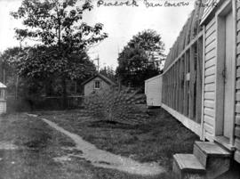
A drive around the park, Stanley Park Stables, a typical party in 1901
Part of Mitchell family fonds

Mrs. McCulloch, Vancouver park

![[Woman among the Seven Sisters in Stanley Park]](/uploads/r/null/4/2/42531f1fbcfafde59cc1a8c75d0b83b30cf76643d8275f49fbcd47dcfdf1d7d8/e1173645-2a4d-41b9-b3b2-19fe8d5310a4-A31868_142.jpg)
[Woman among the Seven Sisters in Stanley Park]
Part of Major Matthews collection

Drive at Brockton Point, Vancouver, B.C.
Part of Major Matthews collection
J.S. Matthews' notes with print or negative in Archives.
![[Woman at wooden staircase near path, Stanley Park]](/uploads/r/null/4/5/457c89c6028bf23763596d6fdc697d21ae95ab0da8b9e499329612e0e3d1d93d/2e27cf54-52d9-4482-9bfd-70bb3ab160bb-A04017_142.jpg)
[Woman at wooden staircase near path, Stanley Park]
Part of Major Matthews collection
J.S. Matthews' notes with print or negative in Archives.
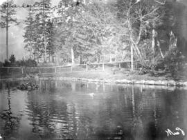
![[Three women observing black swans on pond, Stanley Park]](/uploads/r/null/2/5/2599d75d754e8ceb879c968a4b724c6f25c23ce4388290c65d8bb7a731586d28/9b082a11-fb16-463e-83c0-9db4a2d92f3f-A04016_142.jpg)
[Three women observing black swans on pond, Stanley Park]
Part of Major Matthews collection
J.S. Matthews' notes with print or negative in Archives.
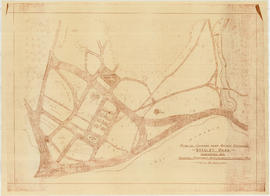
Part of City of Vancouver Archives technical and cartographic drawing collection
Item is a diazotype copy of a site plan which shows gardens, ponds, buildings and roads for the area at the entrance of Stanley Park.
Cartwright Matheson Company (Vancouver, B.C.)
![Map of Stanley Park [site plan]](/uploads/r/null/1/c/1c9f6dc06e0884db9e77fbf60ada5f034a83d9de980993fddeb5e2475c9e2b97/52d1c868-f7bb-48bd-a2e8-0fa3444cfeec-MAP62_142.jpg)
Map of Stanley Park [site plan]
Part of City of Vancouver Archives technical and cartographic drawing collection
Item is a copy of a published map of Stanley Park which has been annotated to show proposed redevelopment plan for the western portion of Coal Harbour (currently Lost Lagoon) and surrounding area. It is believed that this is one of the sheets referred to by Thomas Mawson in his report to the Board of Parks Commissioners regarding various proposed development schemes for the entrance to Stanley Park and the Coal Harbour area.
![[Island in lake, Stanley Park]](/uploads/r/null/f/4/f4d03a172f03857093502f4e38e059e76506cadffcbbb9111d36d92acbc39ea5/e1739b94-63f7-41ca-9414-f94a792179aa-A20570_142.jpg)
[Island in lake, Stanley Park]
Part of James Luke Quiney fonds
![[Scenic path in] Stanley Park](/uploads/r/null/3/1/a/31a1c56290b29916a8c74e8266b48a051c1db684e1721af572528fa143a59b41/902637f5-603c-43ce-abdf-c3aad84796a5-CVA220-16_142.jpg)
![[Open horse drawn carriage, travelling along scenic road in] Stanley Park](/uploads/r/null/d/8/5/d85a923aa0f80b8c301b29795ced370847dc85c32cab99758c158b7092fae73c/b32c95f5-3745-4cea-8f1d-7f94d357d52b-CVA220-15_142.jpg)
[Open horse drawn carriage, travelling along scenic road in] Stanley Park
![[People walking in snow at Stanley Park]](/uploads/r/null/1/1/116bb50e42d368767c847278dff718405623624bb66fd0d4bd89b05e58c78813/6bbf4ddf-c995-46d6-b316-ea2d9eeafa12-A20567_142.jpg)
[People walking in snow at Stanley Park]
Part of James Luke Quiney fonds
Map of Stanley Park, Vancouver, B.C.
Part of City of Vancouver Archives technical and cartographic drawing collection
Map shows roads, trails, horse trails, street railways, beaches and buildings in Stanley Park.

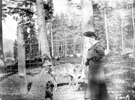
Part of William Orson Banfield fonds
Item is a photograph showing deer and buildings in Stanley Park.

Part of James Crookall fonds
Accepted scheme for Coal Harbour, Stanley Park, Vancouver
Part of Thomas H. Mawson collection
Item is a site plan, depicting a proposed development of the eastern portion of Stanley Park at Coal Harbour. The drawing depicts trails, two playgrounds, a restaurant, a museum, a stadium and a rowing club.
Mawson, Thomas Hayton
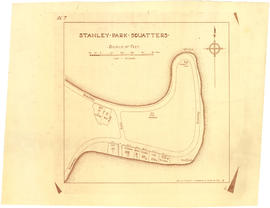
Part of City of Vancouver Archives technical and cartographic drawing collection
Item is a copy of a map showing a portion of Stanley Park and parcels of land labelled with surnames of identified squatters.

Standard tourists' guide to Stanley Park, Vancouver, B.C.
Part of City of Vancouver Archives technical and cartographic drawing collection
Item is a tourist guidebook to Stanley Park, including a brief history, instructions for vehicle access, and a map with associated index to points of interest. The back of the cover lists "A Few Facts About Vancouver. The map notes driving routes in the park, trails and walking routes.

Plan showing lands occupied in Stanley Park near Brockton Point, City of Vancouver, B.C.
Part of City of Vancouver Archives technical and cartographic drawing collection
Map shows parcels of land (1-8) in Stanley Park and indicates what kind of structures are located on the land. The area for each parcel of land is given in acres.

Part of William Orson Banfield fonds