- AM495-F2-: LEG1283.8
- Item
- Sep. 7, 1943
Item is a street map showing Vancouver, Burnaby, New Westminster, West Vancouver, and North Vancouver on one side and Lulu Island and Sea Island, Delta, Surrey, Langley and Maillardville on the other.
447 results with digital objects Show results with digital objects
Item is a street map showing Vancouver, Burnaby, New Westminster, West Vancouver, and North Vancouver on one side and Lulu Island and Sea Island, Delta, Surrey, Langley and Maillardville on the other.
Dial map of the city of Vancouver including the adjacent municipalities
Item is a street map showing Vancouver, Burnaby, New Westminster, West Vancouver and North Vancouver on one side and the University Endowment Lands, Surrey, Maillardville, Lulu Island and Sea Island on the other.

Dial map of Greater Vancouver and suburbs
Part contains a street map of Vancouver, Burnaby, New Westminster, West Vancouver and North Vancouver showing block numbers, street car, bus, and railway lines, parks and hospitals. Map includes two dials (a numbered circle, a paper indicator, a grid of block numbers and a street index used to find locations). A small inset map shows the Capitol Hill/Scenic Park area of Burnaby in greater detail.
Dial map of the city of Vancouver including the adjacent municipalities
Part of City of Vancouver Archives technical and cartographic drawing collection
Item is a street map showing Vancouver, Burnaby, New Westminster, West Vancouver and North Vancouver on one side and the University Endowment Lands, Surrey, Maillardville, Lulu Island and Sea Island on the other.

Dial map of Greater Vancouver and suburbs
Part of City of Vancouver Archives technical and cartographic drawing collection
Part contains a street map of Vancouver, Burnaby, New Westminster, West Vancouver and North Vancouver showing block numbers, street car, bus, and railway lines, parks and hospitals. Map includes two dials (a numbered circle, a paper indicator, a grid of block numbers and a street index used to find locations). A small inset map shows the Capitol Hill/Scenic Park area of Burnaby in greater detail.

Part of City of Vancouver Archives technical and cartographic drawing collection
Item is a map compiled and drawn by J.S. Matthews, City Archivist showing historic place names of Vancouver and the North Shore and listing some historic Burnaby names. A note in the bottom left hand corner reads: "Memorada. The precise location of "Albert City" is unknown, Narveaz was first; 150 years passed before his name was given to a landmark. His vessel's name "Santa Saturnina" has never been applied to anything at all."
Mrs. G. Martin residence : West Vancouver
Part of C.B.K. Van Norman fonds
File consists of the following types of architectural drawings: elevations, floor plans and structural specifications.
Mr. & Mrs. Pat Ritchie residence : Blk 99 DL556 NWD Plan 4948 [West Vancouver]
Part of C.B.K. Van Norman fonds
File consists of the following types of architectural drawings: elevations, floor plans and structural specifications.
Mr. W.J. Campbell residence : [Pilothouse Road] Caulfield, West Vancouver
Part of C.B.K. Van Norman fonds
File consists of the following types of architectural drawings: elevations, floor plans and structural specifications.
Dyke residence : West Vancouver
Part of C.B.K. Van Norman fonds
File consists of the following types of architectural drawings: elevations, floor plans and structural specifications.

Photograph shows a sign promoting bond sales in West Vancouver
George Fitch residence :[906 Campbell, West Vancouver?]
Part of C.B.K. Van Norman fonds
File consists of the following types of architectural drawings: elevations, floor plans and structural specifications.
![[Group portrait of a Sea Cadets class at Whytecliffe]](/uploads/r/null/9/9/99903350e2384a4169a2dd4e2487dcd523251b3e3a5ef544233281636dfda849/03bc8c45-3c98-498c-8a03-0b934a1fd8e2-A11150_142.jpg)
[Group portrait of a Sea Cadets class at Whytecliffe]
![[Group portrait of Prince Rupert Division Sea Cadets class at Whytecliffe]](/uploads/r/null/c/e/cec257f70c6c15543ffda61f1286a051f22844a87632950ad50e2f3dd48bab39/8bf5a45d-6a00-440b-b5c6-cbd5141816f8-A11149_142.jpg)
[Group portrait of Prince Rupert Division Sea Cadets class at Whytecliffe]
![[Premier John Hart and party at the Hollyburn mountain cabin]](/uploads/r/null/4/6/46247d1940f8c3955587bd6f7cfe04338e9848ca2bc541df6daf3cd457f3466b/7c6dd5cc-80e1-482b-850f-b92fce508d19-A10876_142.jpg)
[Premier John Hart and party at the Hollyburn mountain cabin]
![[Group portrait of a Sea Cadets class at Whytecliffe]](/uploads/r/null/6/4/64cd05444e128d6aa6fabb93d64b56a199133846ccc2cec02a046fd32aa05511/94c251a4-1c9c-4c51-99bc-5a38f061c798-A11153_142.jpg)
[Group portrait of a Sea Cadets class at Whytecliffe]
![[Group portrait of a Sea Cadets class at Whytecliffe]](/uploads/r/null/7/d/7d238b2baef3223282981a98127f23a747ef4c88a78732898186b0561cd7650a/d55c50cc-08ad-4f5c-bdf1-747aab03e0db-A11154_142.jpg)
[Group portrait of a Sea Cadets class at Whytecliffe]
![[Group portrait of a Sea Cadets class at Whytecliffe]](/uploads/r/null/2/7/2707d29a028ed9648467446bc53be097524a35efc6e8855339db0becb7f60a93/2baa9d74-c4df-4834-8977-f92828360880-A11155_142.jpg)
[Group portrait of a Sea Cadets class at Whytecliffe]
![[Group portrait of Prince Rupert Division Sea Cadets class at Whytecliffe]](/uploads/r/null/5/d/5d897e6f31f95914a8239bfef67f871e3cdfd14e8e2b603f242ce824c0f5d2bc/2a75103c-df30-4dde-aa3d-9ea1592c6661-A11148_142.jpg)
[Group portrait of Prince Rupert Division Sea Cadets class at Whytecliffe]
![[Portrait of Premier John Hart at the door to the cabin on Hollyburn mountain]](/uploads/r/null/3/3/33301fa5b27bf9fa517e15d1d88709379aee6c436400ed4fe43aa8b1fb408281/9472703c-3d9c-4562-b4b5-4c7502203294-A10875_142.jpg)
[Portrait of Premier John Hart at the door to the cabin on Hollyburn mountain]
![[Premier John Hart and party discussing timber conservation plan on Hollyburn mountain]](/uploads/r/null/b/9/b90cd342575de1b9bc9e7319c9dd5ca0c71aedd574b22dbdc0d1f86ea183bed4/92cbbca9-fbfd-4f5c-bf2d-3fb5c1f32e2a-A10880_142.jpg)
[Premier John Hart and party discussing timber conservation plan on Hollyburn mountain]
![[Full length portrait of Premier John Hart at the door to the Hollyburn cabin]](/uploads/r/null/8/e/8e26c3799b992c088422a62de8d564d20e8be02e771f396e1670a94b8438a343/d2dedd55-6af9-4dac-b8c8-b8550d1d4cd0-A10873_142.jpg)
[Full length portrait of Premier John Hart at the door to the Hollyburn cabin]

[Group portrait of a Sea Cadets class at Whytecliffe
![[Group portrait of a sea Cadets class at Whytecliffe]](/uploads/r/null/6/0/60f9acca66bd422fe0330a224977207954f0056c7abda6ce5c338f024a124177/ad2729d0-d069-4714-a66b-84199bf68c01-A11151_142.jpg)
[Group portrait of a sea Cadets class at Whytecliffe]
![[Premier John Hart and party on Hollyburn mountain to review a timber conservation plan]](/uploads/r/null/a/1/a16e93d947f9714c78ede44e75d3d83a6a05e0b9e04bd82b35cfabafea54cc06/fb38be78-65eb-4d77-a37b-208e533957b1-A10878_142.jpg)
[Premier John Hart and party on Hollyburn mountain to review a timber conservation plan]

![[Premier John Hart and a man sitting in a cleared area near the cabin on Hollyburn mountain]](/uploads/r/null/e/7/e7b2c94a2f8bebd365ed47912dc295265445d22e51ae8b67931e03ffb3aceb00/b9f08945-06d9-4a02-b1cf-ef46161b0310-A10879_142.jpg)
[Premier John Hart and a man sitting in a cleared area near the cabin on Hollyburn mountain]
![[Premier John Hart and party on Hollyburn mountain to review a timber conservation plan]](/uploads/r/null/9/4/945170335f30b65c46be618f7113786b007a5ff5329361325d50daf675921868/a8166737-c3f1-4b69-8643-3132f8ea2483-A10872_142.jpg)
[Premier John Hart and party on Hollyburn mountain to review a timber conservation plan]
![[Premier John Hart and party on Hollyburn mountain to review a timber conservation plan]](/uploads/r/null/f/1/f1cde901e87213236fc61f6eb9c604b2e18f083e120594423ba206ad4b4e4b47/d3bc0265-5b62-4f51-8466-5a558359748c-A10877_142.jpg)
[Premier John Hart and party on Hollyburn mountain to review a timber conservation plan]
![[Group portrait of Prince Rupert division Sea Cadets at Whytecliffe]](/uploads/r/null/1/1/112ec0edf97913189da15a5fbd4422b1be6ebf6b5e5aa3113eecdd877229fce5/7db6765f-e6c1-412a-a36b-41148f40a1ea-A11147_142.jpg)
[Group portrait of Prince Rupert division Sea Cadets at Whytecliffe]
J.B. Hoffar residence : British Pacific properties, [881 Taylor Way?] West Vancouver
Part of C.B.K. Van Norman fonds
File consists of the following types of architectural drawings: cross section, elevation, floor plan and structural specifications.
Residence for British Pacific Properties : Lot E resubdiv. of part Blk 19 D.L. 8 [West Vancouver]
Part of C.B.K. Van Norman fonds
File consists of the following types of architectural drawings: cross section, elevation, floor plan and structural specifications.
S.D. Musham residence : Inglewood Avenue, West Vancouver
Part of C.B.K. Van Norman fonds
File consists of the following types of architectural drawings: cross section, elevation, floor plan and structural specifications.
Part of C.B.K. Van Norman fonds
File consists of the following types of architectural drawings: elevations, floor plans and structural specifications.
J.A. Hunter residence : [1853 Inglewood?] West Vancouver
Part of C.B.K. Van Norman fonds
File consists of the following types of architectural drawings: cross section, elevation, floor plan and structural specifications.
![[Entrance to grounds at Whytecliff Park]](/uploads/r/null/4/8/2/4826250da7e22912c7665d47efaf908161a560bae250c585c3fca10ecadc09ec/7594bd52-0c4c-4aa0-bb05-e2a3cc6bbae0-CVA374-459_142.jpg)
[Entrance to grounds at Whytecliff Park]
![[Ferry launch "Bowen" leaving Whytecliff dock]](/uploads/r/null/d/f/df382b078cfe01c8216f474845d75dcbf77fe8cb6ed45ebdcc0feb094476c99a/319f266b-0fd3-49dd-9c05-20c6d32fb3ec-A49845_142.jpg)
[Ferry launch "Bowen" leaving Whytecliff dock]
Photograph shows Standard Oil filling station on a R.C.A.F. raft
![[View of Bowen Island from Cliffhouse at Whytecliff Park]](/uploads/r/null/0/6/06b4ec54ef6abcc4c2c05e0970a98acaa62decad87061759fa275e28fbed49e8/8321e48c-0853-43d3-b2f4-4a50bf02bafb-A47136_142.jpg)
[View of Bowen Island from Cliffhouse at Whytecliff Park]
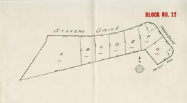
Part of City of Vancouver Archives technical and cartographic drawing collection
Item is a map depicting the area of the British Properties development bordered by Stevens Drive and Hadden Drive near Eastcot Road.
Part of City of Vancouver Archives technical and cartographic drawing collection
File consists of a booklet of maps advertising the sale of lots in the British Properties development in West Vancouver, B.C. Maps show lot dimensions and purchase price (some lots already listed as sold).
![[Verandah restaurant at Cliffhouse]](/uploads/r/null/f/c/4/fc43a22fb6883a2ebc17a140b04e2a1a6cbb3162e576729b08d690e258fcd0a1/2ef50a79-995d-4e3b-b6ab-33faa2c22403-CVA374-466_142.jpg)
[Verandah restaurant at Cliffhouse]
![[View of Bowen Island from Cliffhouse at Whytecliff Park]](/uploads/r/null/8/7/b/87b4bb05281f88d0baa017351a0fd43496121da6dc5c3525120360ad868bb369/ea4aca71-a7e2-414f-8f28-491d5b040cfc-CVA374-464_142.jpg)
[View of Bowen Island from Cliffhouse at Whytecliff Park]
![[Beach at Whytecliff]](/uploads/r/null/1/e/9/1e9faa26f687a828c41a9fa26b939963a09953e79d4f17d1c14938990dd061a9/b8963331-c864-4146-a928-67d14f5367aa-CVA374-471_142.jpg)