Showing 73330 results

Archival description
Vancouver (B.C.)
Print preview View:

70942 results with digital objects Show results with digital objects

Amended sewer layout : False Creek park area (Suggested subdivision : Northern Pacific Railway pr...
Amended sewer layout : False Creek park area (Suggested subdivision : Northern Pacific Railway property)
Proposed sanitary convenience at S. end of Granville Bridge
Plan of proposed public convenience, Georgia & Granville Sts., Vancouver, B.C.
City of Vancouver, British Columbia
Preliminary plan for Vancouver Crematorium
Little Mountain reservoir site
Caretakers cottage. Little Mountain reservoir.
The City of Vancouver, B.C.
City of Vancouver : showing all city owned property [sectional map]
Plan of district lot boundaries, City of Vancouver, B.C.
Sheet 10 : Clark Drive to Slocan Street and Burrard Inlet to Triumph Street
Sheet 8 : McLean Drive to Slocan Street and William Street to Seventh Avenue
Sheet 16 : Maple Street to Oak Street and False Creek to Sixteenth Avenue
Sheet 18 : Trutch Street to Maple Street and English Bay to Third Avenue
Sheet 21 : Burrard Street to False Creek and waterfront to Robson Street
Sheet 6 : Knight Street to Slocan Street and Eighteenth Avenue to Twenty-ninth Avenue
Sheet D : Imperial Street to Trutch Street and Fourth Avenue to Sixteenth Avenue
Sheet G : Trafalgar Street to Granville Street and Sixteenth Avenue to Nanton Avenue
Sheet O : Holland Street to Elm Street and Thirty-eighth Avenue to Forty-ninth Avenue
Sheet T : Marine Crescent to Granville Street and Forty-ninth Avenue to Sixty-first Avenue
Sheet X : Marine Drive to Ash Street and Fifty-ninth Avenue to Seventy-first Avenue
Sheet 6 : Craddock Street to Boundary Road and Twenty-ninth Avenue to Fortieth Avenue
Sheet 3 : Cambie Street to St. George Street and Twenty-seventh Avenue to Thirty-eighth Avenue
Sheet 13 : Fleming Street to Carlton Street and Forty-seventh Avenue to Fifty-ninth Avenue
Sheet 11 : Cambie Street to St. George Street and Forty-seventh Avenue to Fifty-eighth Avenue
Sheet 9 : Fleming Street to Carlton Street and Thirty-seventh Avenue to Forty-eighth Avenue
Sewage, water services and actual occupancy - area bounded by Joyce Street, Boundary Road, Wellington Avenue and Kingsway
Sewage : area bounded by Joyce Street, Boundary Road, Wellington Avenue and Kingsway
Fourteenth Annual fireman's ball, 1912, invitation
Fourteenth Annual fireman's ball, 1912, dance program, front page
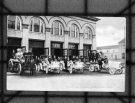
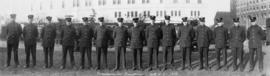
Firehall auto brigade, Vancouver, B.C.
Vancouver Fire Department - Hall No. 2
Vancouver Fire Department No. 18
Firefighters and equipment in action at G.H. Cottrell Warehouse, 139 Water Street
Firefighting equipment at scene of Imperial Oil Company fire, Smithe Street
Fire Department Band performing by pool in front of bleachers
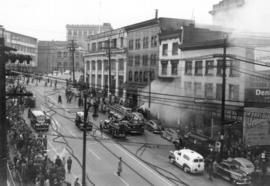
Fire engines and spectators at three alarm fire at Park Hotel
Group portrait of fire chiefs in civilian dress with reporter Simma Holt
Aerial view of Downtown Vancouver, West End and Yaletown, with Granville Street Bridge and Burrar...
Aerial view of Downtown Vancouver, West End and Yaletown, with Granville Street Bridge and Burrard Street Bridge, and C.P.R. [Canadian Pacific Railway] train yards
Aerial view of Vancouver City Hall and residential housing, facing east, on Cambie Street
Aerial view of Mount Pleasant, False Creek, at Main Street and Terminal Avenue, with Canadian Cen...
Aerial view of Mount Pleasant, False Creek, at Main Street and Terminal Avenue, with Canadian Central Station, Opsal Steel, Murrin Substation and Georgia Viaduct
Aerial view of False Creek, facing Mount Pleasant and Fairview, with Cambie Street Bridge, Vancou...
Aerial view of False Creek, facing Mount Pleasant and Fairview, with Cambie Street Bridge, Vancouver General Hospital, Vancouver City Hall
Close aerial view of Vancouver City Hall, with Cambie Street and cars
Aerial view of Downtown Vancouver with Stanley Park, North Vancouver, West Vancouver, North Shore...
Aerial view of Downtown Vancouver with Stanley Park, North Vancouver, West Vancouver, North Shore mountains and Burrard, Granville and Cambie Street bridges
Aerial view of False Creek at 2nd Avenue with Cambie Street Bridge and Canadian Western Cooperage...
Aerial view of False Creek at 2nd Avenue with Cambie Street Bridge and Canadian Western Cooperage sawmill
Aerial view of False Creek at Stamp's Landing with Cambie Street Bridge and Heather Civic Marina ...
Aerial view of False Creek at Stamp's Landing with Cambie Street Bridge and Heather Civic Marina and Yaletown Marina
Aerial view of Downtown Vancouver and False Creek, with Fairview, Stanley Park, Cambie Street Bri...
Aerial view of Downtown Vancouver and False Creek, with Fairview, Stanley Park, Cambie Street Bridge, North Vancouver, Lions Gate Bridge, and law courts under construction
Aerial view of Downtown Vancouver and False Creek, between Burrard Street and Granville Street Br...
Aerial view of Downtown Vancouver and False Creek, between Burrard Street and Granville Street Bridge, with train bridge and Granville Island
Legend [for colour coding land use]
Results 1 to 50 of 73330