Showing 73337 results

Archival description
Vancouver (B.C.)
Print preview View:

70942 results with digital objects Show results with digital objects

Sewage, water services and actual occupancy - area bounded by Joyce Street, Boundary Road, Wellington Avenue and Kingsway

File consists of three identical base maps of the area from Earles Street to Boundary Road and 29th Avenue to 49th Avenue, which have been annotated to show the sewage system, water services system, and types of occupancy in the area bounded by Joyce Street, Boundary Road, Wellington Avenue and Kingsway.

City of Vancouver : showing all city owned property [sectional map]

File consists of three maps, including one sectional maps. The maps include an index to the sections, an index to District Lots, and one sectional map in 61 sections. The sections have been annotated with colour coding to show tax sale property for sale, property with no water, street widening and drainage, replotting, reserved land for schools, reserved land for parks, sundry land, capital assets not including schools and parks, schools, and parks. An index to the colour coding was hand-drawn on the verso of the sheet with the index to District Lots.

Vancouver (B.C.). Office of the City Engineer

Plan of district lot boundaries, City of Vancouver, B.C.

Item is a map of Vancouver showing district lot boundaries.

The map identifies First Nations reserves, the University Endowment Lands, Stanley Park, Old Granville Townsite and Hastings Townsite. On the verso of the map is a legend indicating the colours used on the maps in this file to define areas of tax sale property for sale, no water, street widening - drainage, replotting, reserved school, reserved park, sundry, capital assets (except schools and parks), schools, and parks.

Vancouver (B.C.). Office of the City Engineer

Sheet 10 : Clark Drive to Slocan Street and Burrard Inlet to Triumph Street

Item is a section showing the area from Clark Drive to Slocan Street and aterfront to Triumph Street. Includes streets and roads, blocks, lots, legal descriptions, railways, parks, boys' detention home and businesses along the waterfront. The Town of Hastings is indicated on the map. Map is hand coloured to show tax sale property for sale, property with no water, street widening and drainage, replotting, reserved land for schools, reserved land for parks, sundry land, capital assets not including schools and parks, schools, and parks, as applicable.

Vancouver (B.C.). Office of the City Engineer

Sheet 8 : McLean Drive to Slocan Street and William Street to Seventh Avenue

Item is a section showing the area from McLean Drive to Slocan Street and William Street to Seventh Avenue. Includes streets and roads, blocks, lots, legal descriptions, railways, parks, schools and some businesses. Map is hand coloured to show tax sale property for sale, property with no water, street widening and drainage, replotting, reserved land for schools, reserved land for parks, sundry land, capital assets not including schools and parks, schools, and parks, as applicable. Some annotations have been made in pencil.

Vancouver (B.C.). Office of the City Engineer

Sheet 16 : Maple Street to Oak Street and False Creek to Sixteenth Avenue

Item is a section showing Maple Street to Oak Street and False Creek to Sixteenth Avenue. Includes streets and roads, blocks, lots, legal descriptions, railways, schools and parks. Indicates crown land leased to the C.P.R. and other bodies. Map is hand coloured to show tax sale property for sale, property with no water, street widening and drainage, replotting, reserved land for schools, reserved land for parks, sundry land, capital assets not including schools and parks, schools, and parks.

Vancouver (B.C.). Office of the City Engineer

Sheet 18 : Trutch Street to Maple Street and English Bay to Third Avenue

Item is a section showing Trutch Street to Maple Street and English Bay to Third Avenue. Includes streets, roads, blocks, lots, legal descriptions, parks and crown grants. Map is hand coloured to show tax sale property for sale, property with no water, street widening and drainage, replotting, reserved land for schools, reserved land for parks, sundry land, capital assets not including schools and parks, schools, and parks.

Vancouver (B.C.). Office of the City Engineer

Sheet 21 : Burrard Street to False Creek and waterfront to Robson Street

Item is a section showing Burrard Street to False Creek and waterfront to Robson Street. Includes streets and roads; blocks, lots and legal descriptions; the locations of hotels, court house, businesses, parks, and schools; crown leases; C.P.R. land and the company's Piers B and C, yards, sheds and depot; the B.C. Electric Railway Carrall Street Yard; and the Union Steamship Company. Map is hand coloured to show tax sale property for sale, property with no water, street widening and drainage, replotting, reserved land for schools, reserved land for parks, sundry land, capital assets not including schools and parks, schools, and parks, as applicable.

Vancouver (B.C.). Office of the City Engineer

Sheet 6 : Knight Street to Slocan Street and Eighteenth Avenue to Twenty-ninth Avenue

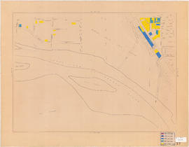
Item is a section showing the area from Knight Street to Slocan Street and Eighteenth Avenue to Twenty-ninth Avenue. Includes streets and roads, blocks, lots, legal descriptions, railways, parks and schools. Some annotations have been made in pencil. Map is hand coloured to show tax sale property for sale, property with no water, street widening and drainage, replotting, reserved land for schools, reserved land for parks, sundry land, capital assets not including schools and parks, schools, and parks. Map is hand coloured to show tax sale property for sale, property with no water, street widening and drainage, replotting, reserved land for schools, reserved land for parks, sundry land, capital assets not including schools and parks, schools, and parks, as applicable.

Vancouver (B.C.). Office of the City Engineer

Sheet D : Imperial Street to Trutch Street and Fourth Avenue to Sixteenth Avenue

Item is a section showing the area from Imperial Street to Trutch Street and Fourth Avenue to Sixteenth Avenue. Includes streets and roads; blocks; lots and legal descriptions; and parks, schools and golf courses. Section is annotated to show tax sale property for sale, property with no water, street widening and drainage, replotting, reserved land for schools, reserved land for parks, sundry land, capital assets not including schools and parks, schools, and parks, as applicable.

Vancouver (B.C.). Office of the City Engineer

Sheet G : Trafalgar Street to Granville Street and Sixteenth Avenue to Nanton Avenue

  • COV-S303-MAP 343-: MAP 343.32
  • Item
  • Feb. 22, 1939, with revisions to Nov. 23, 1943
  • Part of City of Vancouver fonds

Item is a section showing the area from Trafalgar Street to Granville Street and Sixteenth Avenue to Nanton Avenue. Includes streets, roads and sewers; blocks, lots and legal descriptions; and parks, railway lines and schools. Section is annotated to show tax sale property for sale, property with no water, street widening and drainage, replotting, reserved land for schools, reserved land for parks, sundry land, capital assets not including schools and parks, schools, and parks, as applicable.

Vancouver (B.C.). Office of the City Engineer

Sheet O : Holland Street to Elm Street and Thirty-eighth Avenue to Forty-ninth Avenue

Item is a section showing the area from Holland Street to Elm Street and Thirty-eighth Avenue to Forty-ninth Avenue. Includes streets, roads and sewers; blocks, lots and legal descriptions; and golf courses, parks and schools. Map is hand coloured to show tax sale property for sale, property with no water, street widening and drainage, replotting, reserved land for schools, reserved land for parks, sundry land, capital assets not including schools and parks, schools, and parks, as applicable.

Vancouver (B.C.). Office of the City Engineer

Sheet T : Marine Crescent to Granville Street and Forty-ninth Avenue to Sixty-first Avenue

Item is a section showing the area from Marine Crescent to Granville Street and Forty-ninth Avenue to Sixty-first Avenue. Includes streets and roads; blocks, lots and legal descriptions; and parks and golf courses. Map is hand coloured to show tax sale property for sale, property with no water, street widening and drainage, replotting, reserved land for schools, reserved land for parks, sundry land, capital assets not including schools and parks, schools, and parks, as applicable.

Vancouver (B.C.). Office of the City Engineer

Sheet X : Marine Drive to Ash Street and Fifty-ninth Avenue to Seventy-first Avenue

Item is a section showing the area from Marine Drive to Ash Street and Fifty-ninth Avenue to Seventy-first Avenue. Includes streets and roads; blocks, lots and legal descriptions; and parks and schools. Map is hand coloured to show tax sale property for sale, property with no water, street widening and drainage, replotting, reserved land for schools, reserved land for parks, sundry land, capital assets not including schools and parks, schools, and parks, as applicable.

Sheet 6 : Craddock Street to Boundary Road and Twenty-ninth Avenue to Fortieth Avenue

Item is a section showing the area from Craddock Street to Boundary Road and Twenty-ninth Avenue to Fortieth Avenue. Includes streets, roads, blocks, lots, legal descriptions, parks. railway lines and schools. Map is hand coloured to show tax sale property for sale, property with no water, street widening and drainage, replotting, reserved land for schools, reserved land for parks, sundry land, capital assets not including schools and parks, schools, and parks, as applicable.

Vancouver (B.C.). Office of the City Engineer

Sheet 3 : Cambie Street to St. George Street and Twenty-seventh Avenue to Thirty-eighth Avenue

Item is a section showing the area from Cambie Street to St. George Street and Twenty-seventh Avenue to Thirty-eighth Avenue. Map shows streets, roads, blocks, lots and legal descriptions and the locations of parks, schools, reservoirs and Mountainview Cemetery. Map is hand coloured to show tax sale property for sale, property with no water, street widening and drainage, replotting, reserved land for schools, reserved land for parks, sundry land, capital assets not including schools and parks, schools, and parks, as applicable.

Vancouver (B.C.). Office of the City Engineer

Sheet 13 : Fleming Street to Carlton Street and Forty-seventh Avenue to Fifty-ninth Avenue

Item is a section showing the area from Fleming Street to Carlton Street and Forty-seventh Avenue to Fifty-ninth Avenue. Includes streets, roads, blocks, lots, legal descriptions, parks and schools. Map is hand coloured to show tax sale property for sale, property with no water, street widening and drainage, replotting, reserved land for schools, reserved land for parks, sundry land, capital assets not including schools and parks, schools, and parks, as applicable.

Vancouver (B.C.). Office of the City Engineer

Sheet 11 : Cambie Street to St. George Street and Forty-seventh Avenue to Fifty-eighth Avenue

Item is a section showing the area from Cambie Street to St. George Street and Forty-seventh Avenue to Fifty-eighth Avenue. Includes streets, roads, blocks, lots, legal descriptions, golf courses, parks and schools. Map is hand coloured to show tax sale property for sale, property with no water, street widening and drainage, replotting, reserved land for schools, reserved land for parks, sundry land, capital assets not including schools and parks, schools, and parks, as applicable.

Vancouver (B.C.). Office of the City Engineer

Sheet 9 : Fleming Street to Carlton Street and Thirty-seventh Avenue to Forty-eighth Avenue

Item is a section showing the area from Fleming Street to Carlton Street and Thirty-seventh Avenue to Forty-eighth Avenue. Includes streets, roads, blocks, lots, legal descriptions, parks and schools. Map is hand coloured to show tax sale property for sale, property with no water, street widening and drainage, replotting, reserved land for schools, reserved land for parks, sundry land, capital assets not including schools and parks, schools, and parks, as applicable.

Vancouver (B.C.). Office of the City Engineer

Project 2 : generalized plan of redevelopment

Item is the index map showing the boundaries of the various sub-areas of redevelopment project no. 2. The map shows the boundaries of clearance and redevelopment areas, the proposed street system and the proposed land use for the area from Burrard Inlet in the north to 16th Avenue in the south and from Nanaimo Street in the east to Arbutus Street in the west.

Project 2, part of area "a" : condition of buildings

Item is a map showing the condition of buildings (ranging from very good to very poor) within the boundaries of project 2, area "a". The map also shows the boundaries of project 2 clearance, the boundaries of project 1 clearance and the realignment of Raymur Avenue.

Project 2, area a-2 : condition of buildings

Item is a map showing condition of buildings (ranging from very good to very poor) and sites without buildings in use for storage or parking in the area from Railway Street in the north to Atlantic Street in the south and from Clark Drive in the east to Main Street in the west.

Project 2: identification plan

Item is a map showing city owned property, adjacent lots in same ownership, non-adjacent lots in same ownership, property to be acquired, streets and lanes to be acquired, the boundaries of project 2 clearance, the boundaries of project 1 clearance and the realignment of Raymur Avenue in the area from Railway Street in the north to Atlantic Street in the south and from Clark Drive in the east to Main Steet in the west.

Project 2, area a-2 : proposed property acquisitions project 2

Item is a map showing boundaries of project in area a, property to be acquired, proposed street widening and city owned property included. Annotations show boundaries of project areas, property too be acquired, proposed street widening and properties already owned by the City. Map has been noted as Preliminary.

Project 2, part of area "a" : aerial photograph

Item is a map in the form of an aerial photograph, which depicting the part of the city covered by the project: from Railway Street in the north to Prior Street in the south and from Clark Drive in the east to Main Street in the west.

Attached label indicates that the map was approved by Council Sept. 17, 1963.

Project 2, part of area "a" : existing utilities, water and sewer

Item is a map showing the water pipes (10" and over), the sewers (15" and over), the direction of sewer flow, the boundaries of project 2 clearance, the boundaries of project 1 clearance and the realignment of Raymur Avenue in the area from Burrard Inlet in the north to Atlantic Street in the south and from Clark Drive in the east to Main Street in the west.

Attached label indicates that the map was approved by Council Sept. 17, 1963.

Project 2, part of area "a" : existing utilities, gas, electricity and telephone

Item is a map showing the gas lines, the overhead and underground electricity lines, the overhead and underground telephone lines, the fire alarms underground, the boundaries of project 2 clearance, the boundaries of project 1 clearance and the realignment of Raymur Avenue in the area from Railway Street in the north to Atlantic Street in the south and from Clark Drive in the east to Main Street in the west.

Attached label indicates that the map was approved by Council Sept. 17, 1963.

Project 2, part of area "a" : utility diversions and rearrangements

Item is a map showing boundaries of clearance areas for project 2 (areas 5 (part), 6 and 7) and project 1 (area 3). Maps also show sewers to remain, sewers to be abandoned, water lines to remain, water lines to be abandoned, gas lines to remain, gas lines to be abandoned, power lines existing underground, proposed diversions of power lines, power lines existing overhead, proposed overhead power lines and long distance telephone lines existing underground. Larger map shows area from Hastings Street in the north to Union Street in the south and from Heatley Avenue in the east to Gore Avenue in the west. Smaller map shows area from Powell Street in the north to Hastings Street in the south and from Clark Drive in the east to Glen Drive in the west. Item also shows estimates of costs for utility diversions and rearrangements for areas 5, 6 and 7.

Attached label indicates that the map was approved by Council Sept. 17, 1963.

Project 2, part of area "a" : identification plan

Item is a map showing city owned property, adjacent lots in same ownership, non-adjacent lots in same ownership, property to be acquired, streets and lanes to be acquired, the boundaries for project 2 clearance, the boundaries for project 1 clearance and the realignment of Raymur Ave for the area from Railway Street in the north to Atlantic Street in the south and from Clarke Drive in the east to Main Street in the west.

Attached label indicates that the map was approved by Council Sept. 17, 1963.

Redevelopment Project No. 2 Plan No. 1

Item is an index plan showing the various area sub-projects for redevelopment project no. 2, and designates comprehensive vs. limited re-development areas. Area A-6 is highlighted in red.

City of Vancouver, east approach route. Alignment alternatives investigated

Item is a map which has been created out of a sepia diazotype copy of an aerial photograph of downtown Vancouver. The map has been annotated to show thirteen different schemes for freeway routes to connect the Trans-Canada Highway with downtown Vancouver from the east. The map shows the consultants' preferred route and other alignments investigated.

Phillips, Barratt, Hillier, Jones and Partners, Engineers (Vancouver, B.C.)

Government precinct

Item shows locations and exteriors of buildings in the area bounded by Oak Street, Yukon Street, Broadway, and 16th Avenue.

Results 1 to 50 of 73337