
- AM738-S1-: MAP 906
- Item
- [ca. 1960]
Item is a map of Greater Vancouver showing streets, parks, schools and hospitals; includes street index.
Item is a map of Greater Vancouver showing streets, parks, schools and hospitals; includes street index.

Street map of Greater Vancouver, B.C.
Part of City of Vancouver Archives technical and cartographic drawing collection
Part contains a street map of Greater Vancouver showing block numbers, neighbourhood boundaries, schools, churches by denomination, and main shopping centres. An inset map shows the Forest Hills - Canyon Heights area.

Guide map: Vancouver - New Westminster, Burnaby and North Shore municipalities
Part of City of Vancouver Archives technical and cartographic drawing collection
Item is a street map of Vancouver, Burnaby, New Westminster and the North Shore showing city limits and boundaries of central office areas. Map has been annotated to show the old and new Vancouver telephone exchange boundaries prior to and after the introduction of flat rate service on November 1, 1937.

Greater Vancouver, British Columbia : regional major street plan
Part of City of Vancouver Archives technical and cartographic drawing collection
Item is a map which has been removed from a copy of the report "A plan for the City of Vancouver, British Columbia, including Point Grey and South Vancouver and a general plan of the region", commissioned by the Vancouver Town Planning Commission from the planning consultants Harland Bartholomew & Associates.
The map shows existing and proposed additions to the Greater Vancouver major street plan.
Harland Bartholomew and Associates

Map of Fraser Valley ; Street map of New Westminster ; Map of Greater Vancouver transit lines
Part consists of a street map of the Lower Mainland and Fraser Valley from Vancouver to Chilliwack, a street map of New Westminster, a map showing transit lines in Greater Vancouver, and text advertising the products and services of the Dominion Map and Blueprint Company.

Map and guide of Greater Vancouver
Part of City of Vancouver Archives technical and cartographic drawing collection
Item is a map and guide designed to be folded into a pocket-sized cover. Map shows streets, legal addresses, railway lines, and distances from City Hall. Text includes information on streetcar lines, train and steamship services, postal service, places of worship, office buildings, schools, and theatres.
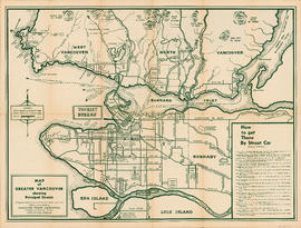
Map of Greater Vancouver showing principal streets
Part of Simson family fonds
Part contains a map of Greater Vancouver showing streets, parks, golf courses, mountains, rivers, and distances from city centre, and a guide to streetcar routes to selected attractions.

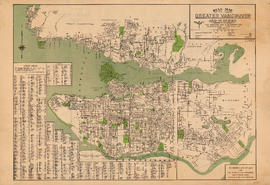
Street map of Greater Vancouver, B.C.
Part of City of Vancouver Archives technical and cartographic drawing collection
Part contains a map of Greater Vancouver showing highways, streets, parks, golf courses and country clubs, institutions, block numbers, city and municipal boundaries and Shell marine stations.

Street map of Greater Vancouver, B.C.
Part of City of Vancouver Archives technical and cartographic drawing collection
Part contains a street map of Greater Vancouver showing block numbers, parks, golf courses, cemeteries, and hospitals; inset maps showing streets in Coquitlam and the Horseshoe Bay area; and a map showing Highway 99 from Horseshoe Bay to Squamish.

Part of City of Vancouver Archives technical and cartographic drawing collection
Part contains maps of the Richmond and downtown Vancouver transit systems, a street index to the Greater Vancouver map on the other side of the sheet, information on B.C. Electric transit routes, and general tourist information.

Part of City of Vancouver Archives technical and cartographic drawing collection
Part contains a street map of Greater Vancouver.
![City of Vancouver surrounding [sic] and municipalities including City of New Westminster](/uploads/r/null/8/9/1/8919931915a624a5abd2e5d2953118fdd853654343ce31193f00d341d482bf39/fd6eb299-3e6a-498e-bfd9-62a3279a8861-LEG1329_142.jpg)
City of Vancouver surrounding [sic] and municipalities including City of New Westminster
Part of City of Vancouver Archives technical and cartographic drawing collection
Part contains a street map showing distances from a point in downtown Vancouver, waterfront businesses in Burrard Inlet, street car lines, bus lines, parks, golf courses, schools and hospitals.

Part of City of Vancouver Archives technical and cartographic drawing collection
Part contains a street map of Greater Vancouver with street index, an inset map showing the streets of Horseshoe Bay, Whytecliff, and Caulfeild, and advertising Chevron gasolines and RPM motor oils.

Guide map : Vancouver, New Westminster, Burnaby and North Shore municipalities
Part of City of Vancouver Archives technical and cartographic drawing collection
Part contains a map of Greater Vancouver showing city streets, schools, firehalls, parks and golf courses, railways, street railways and interurban lines, hospitals and bus routes.

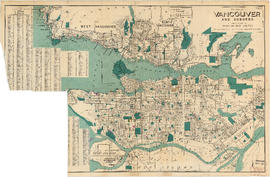
Map of Vancouver, Burnaby, New Westminster, British Columbia : street index and advertisements
Part of City of Vancouver Archives technical and cartographic drawing collection
Part contains a street index for the main map of Vancouver on the other side of the sheet, advertisements for Bekins Moving and Storage and Allied Van Lines, and three maps showing the companies' service areas in the United States, Canada, and British Columbia and Alberta. An annotation reads: "Oppenheimer collection."

Part of City of Vancouver Archives technical and cartographic drawing collection
Part contains a map of Greater Vancouver showing the locations of Bekins Moving and Storage, distances from the Burrard Street and York Street location and city streets. Part includes four photographic images of points of interest in Vancouver.

Wrigley's new map of Vancouver and Lower Mainland
Part of City of Vancouver Archives technical and cartographic drawing collection
Part contains a map showing streets and block numbers in Vancouver, West Vancouver, North Vancouver, Burnaby, New Westminster and the northern part of Richmond.

Transit system map of Greater Vancouver, B.C.
Part consists of a map showing trolley coach lines, bus lines, street car lines, interurban lines, interurban stops, route numbers, B.C. Electric installations and block numbers in West Vancouver, North Vancouver, Vancouver, Burnaby and the University Endowment Lands.

Dial map of Greater Vancouver and suburbs
Part contains a street map of Vancouver, West Vancouver, North Vancouver, and Burnaby showing railways, hospitals, parks and block numbers. The map includes the printed portion of the dial (a numbered circle, a grid of block numbers and a street index used to find locations), but no indicator is attached. A small inset shows the streets of Gleneagles in West Vancouver.
Dial map of Vancouver and suburbs
Part consists of a street map of Vancouver, West Vancouver, North Vancouver, and Burnaby. Part includes the printed portion of the dial (a numbered circle, a grid of block numbers and a street index used to find locations), but no indicator is attached.

Street map of Richmond, Langley, Coquitlam, Delta, Surrey, Pitt Meadows and Maple Ridge
Part includes a small inset map showing the city of New Westminster.
Dial map of Greater Vancouver and suburbs
Part contains a street map of Vancouver, West Vancouver, North Vancouver, and Burnaby. Map includes the printed portion of the dial (a numbered circle, a grid of block numbers and a street index used to find locations), but no indicator is attached.

Guide map : Vancouver, New Westminster, Burnaby and North Shore municipalities : street index
Part of City of Vancouver Archives technical and cartographic drawing collection

Street index of Vancouver and lower mainland
Part of City of Vancouver Archives technical and cartographic drawing collection
Part contains the street index for a map of Greater Vancouver and advertisements for Roy Wrigley Printing and Publishing Co. and A.E. Austin and Co. Limited.