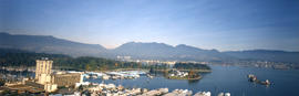
![[Aerial view of Vancouver looking east]](/uploads/r/null/9/3/93309104da24ef0ea4391055c01c783c88d8d52c9939ee604b894d907555df68/564df6c6-3fbe-40b9-bba9-6386ae62ff3c-A23479_142.jpg)
[Aerial view of Vancouver looking east]
- AM54-S4-: Air P81.2
- Item
- 1956
Part of Major Matthews collection
Photograph shows the waterfront along Burrard Inlet, Downtown, West End, Pender Street, West Georgia Street and Robson Street.
1079 results with digital objects Show results with digital objects
[Aerial view of Vancouver looking east]
Part of Major Matthews collection
Photograph shows the waterfront along Burrard Inlet, Downtown, West End, Pender Street, West Georgia Street and Robson Street.
![[Aerial view of Vancouver looking northeast]](/uploads/r/null/e/b/eb04990a1e0714b74de255da43c9b8ae6f6f52e23bbf3735f707b20d0463fbe0/b9785bd2-0b41-4ed0-9f20-b5faf38aaf2f-A23478_142.jpg)
[Aerial view of Vancouver looking northeast]
Part of Major Matthews collection
Photograph shows Kits Point, Kitsilano, Downtown, West End, False Creek, Burrard Bridge and the Granville (Street) Bridge.
![[Aerial view of Vancouver]](/uploads/r/null/1/8/18f00497f9008905bcbff6f62bdc7c5625e266a0ac6b757f9d501d5684921d8a/b6974d97-c2a6-46b1-b55e-581ed03796c9-A23519_142.jpg)
Part of Major Matthews collection
Oblique view. Photograph shows the Westend, Downtown, Coal Harbour and Burrard Inlet.
![[Aerial view of western side Bowen Island, Langdale and Keats Island]](/uploads/r/null/c/f/cfa3b48707527f99931a8687eb7821100c5cf3941db7aec18fcb3355c4cd0320/ce3f1d50-7991-4fec-bd64-b5d9b2f2afe2-A31871_142.jpg)
[Aerial view of western side Bowen Island, Langdale and Keats Island]
Part of Major Matthews collection
![[Aerial view of] Kitsilano Beach and Park](/uploads/r/null/a/a/aaf846b92134a6c4802b0cc7a4d4c78d1c43de3c9093eb2406f56e46bebc2570/aab15264-7e1c-4aaa-971e-c4d581b93623-A23415_142.jpg)
[Aerial view of] Kitsilano Beach and Park
Part of Major Matthews collection
Oblique view. Photograph shows Kitsilano swimming pool, Kits Point and the R.C.A.F. Equipment Depot.
![[Aerial view of] The New International Air Terminal - Vancouver, Canada](/uploads/r/null/3/2/328313cf8ea4726ce90bea4bf466f27d0ec0bbfd9875d4262ffc84535ae1313d/90186d0f-81aa-4e5f-a5d3-85e4eab88bdf-A23523_142.jpg)
[Aerial view of] The New International Air Terminal - Vancouver, Canada
Part of Major Matthews collection
Oblique view. Photograph shows Canadian Pacific Airlines and Air Canada planes at the terminal.
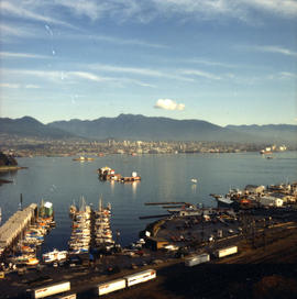
![[Eastern view of Vancouver's waterfront]](/uploads/r/null/e/6/e6c8b31b7f9fdcdb39ea15c2f8c416643495406655370ab1b0674baefc887af3/c5f54d6e-fafc-4db5-840f-ee6af9f443ec-A43370_142.jpg)
[Eastern view of Vancouver's waterfront]
Part of Major Matthews collection
Oblique view showing Ballantine Pier, Buckerfields, the Second Narrows (cantilever) Bridge and the North Shore in the background

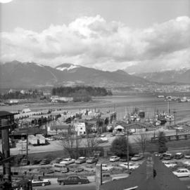
Aerial view of Gayway amusement rides and attractions on P.N.E. grounds

Aerial photograph of P.N.E. grounds
![[Aerial photograph of downtown Nanaimo B.C.]](/uploads/r/null/6/5/65cde66194e385688e218734e0d220ed5ee7ad328ef1509e29b092e2bccd990c/9b09da99-a3e3-4278-bfef-a729495916b4-A38724_142.jpg)
[Aerial photograph of downtown Nanaimo B.C.]
Aerial view of ferry terminal, downtown Nanaimo
![[Aerial photograph of downtown Vancouver and Burrard Inlet waterfront]](/uploads/r/null/8/8/880f3eb359e4ba87a53dbb1528c9a52637f0890bd7fa1f026f2a2f8d55770b5f/07f1720e-3884-4019-874b-7ae1f538a5ea-A38733_142.jpg)
[Aerial photograph of downtown Vancouver and Burrard Inlet waterfront]
Aerial photograph looking west down Georgia Street, showing Lost Lagoon and Coal Harbour
![[Aerial view of Vancouver General Hospital complex]](/uploads/r/null/0/b/0/0b051003f4129ccb3a10f83c721878865509cd6ebfc12da14ed1309cec7b5aa0/f30b5587-d175-4041-ad8c-5703a5db260b-CVA1399-624_142.jpg)
[Aerial view of Vancouver General Hospital complex]
Oblique view showing King Edward High School and False Creek
![[Photograph of Capilano Crushing Co., plant #1, 606 Marine Dr., West Vancouver B.C.]](/uploads/r/null/a/8/a84134ad033f61f6fd54ebe6dfbd15b0a9ee2087e7063eae8f431106a9b93fd0/8d78a63e-a5d6-449b-9839-3d88cc65171b-A38721_142.jpg)
[Photograph of Capilano Crushing Co., plant #1, 606 Marine Dr., West Vancouver B.C.]
Aerial photograph of Burrard Inlet First Narrows. Some features have been marked on the photograph, with corresponding annotations on the back
![[S.S. "Lady Alexandra"]](/uploads/r/null/7/4/e/74e87d22579d72c80b76610fb6a3083e0a77f35f8abf9edcf8901caa3937305e/0a29283e-c0ae-465f-b3c8-bc4c0e86379a-CVA374-95_142.jpg)
Oblique view
![[View of Vancouver waterfront showing Union Dock]](/uploads/r/null/d/d/7/dd7ab36410c42b9534434120e65592352742facf102963e83e7d56a08e4dd00e/88ad4685-0b94-4bb5-801e-318dd133e0f9-CVA374-145_142.jpg)
[View of Vancouver waterfront showing Union Dock]
Oblique view showing C.P.R. Pier H, and the Evans, Coleman and Evans docks, buildings near the waterfront and the Georgia Viaduct in the background

H.M.C.S. St. Thomas on convoy duty, in North Atlantic, taken from the air
Castle Class Corvette purchased post-war and converted to Union Vessel "Camosun" (III)

Oblique view

Part of Stuart Thomson fonds
Oblique view looking east along Broadway showing Kitsilano, the B.C.E.R. Lulu Island line, and the Kitsilano Trestle and Granville Bridges, Granville Island, Fairview, Downtown and Yaletown in the background

Capilano Valley and the Lions, Canyon View Hotel in foreground
Part of Stuart Thomson fonds
Oblique view

Looking East showing Second Narrows and North Arm of Burrard (South Shore of Inlet - Hastings East)
Part of Stuart Thomson fonds
Oblique view showing sawmills
![[Minoru] Park showing track and buildings looking southeast](/uploads/r/null/6/4/648cb80afef74a65543688d3530a5fa0d34e02ce9846a15129939eea7e4998b1/d114b0d7-d9de-4451-bad0-efa589fd7bc4-A44692_142.jpg)
[Minoru] Park showing track and buildings looking southeast
Part of Stuart Thomson fonds
Oblique view
![[Aerial view of West End and Stanley Park]](/uploads/r/null/4/d/4/4d4e724e2a486490856fe60b67dfeee43429a3860f0dd9901058a9e86f640a07/120e79a6-7374-40bd-b57b-8eaac78f191c-CVA374-180_142.jpg)
[Aerial view of West End and Stanley Park]
Oblique view showing English Bay and North Vancouver in the background


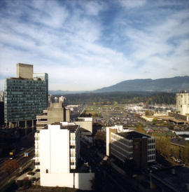
British Columbia - Vancouver skyline
Item is aerial photograph showing downtown Vancouver and Burrard Inlet.

British Columbia - Vancouver skyline
Item is aerial photograph showing downtown Vancouver.

British Columbia - Vancouver skyline : Westcoast bldg. and scenery from inside
Item is aerial photograph showing Coal Harbour and Stanley Park.
Item is photograph showing an aerial view of Stanley Park and Coal Harbour.

Item is aerial photograph showing people walking around the PNE exhibition grounds.

British Columbia - Vancouver skyline
Item is photograph showing an aerial view of Burrard Inlet showing the southern shoreline and parts of Stanley Park.

British Columbia - Vancouver skyline
Item is aerial photograph showing Coal Harbour and Stanley Park from the south shore.

British Columbia - Vancouver skyline
Item is aerial photograph showing construction of downtown Vancouver.

British Columbia - Vancouver skyline
Item is aerial photograph showing downtown Vancouver looking north west towards Stanley Park.

British Columbia - Vancouver skyline
Item is aerial photograph showing downtown Vancouver looking north west towards Stanley Park.
British Columbia - Vancouver skyline
Item is aerial photograph showing part of Coal Harbour and Burrard Inlet.
British Columbia - Vancouver skyline
Item is aerial photograph showing downtown Vancouver looking north west towards Stanley Park.
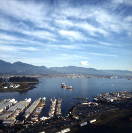
British Columbia - Vancouver skyline
Item is aerial photograph showing part of Coal Harbour and Burrard Inlet.

British Columbia - Vancouver skyline
Item is aerial photograph of Coal Harbour and Stanley Park.

British Columbia - Vancouver skyline
Item is aerial photograph showing Coal Harbour and Burrard Inlet.

British Columbia - Vancouver skyline
Item is aerial photograph showing Coal Harbour and Stanley Park.
British Columbia - Vancouver skyline
Item is aerial photograph of Stanley Park and Coal Harbour.

British Columbia - Vancouver skyline
Item is aerial photograph of downtown Vancouver looking north west towards Stanley Park.

British Columbia - Vancouver skyline
Item is aerial photograph showing a panoramic view of downtown Vancouver looking north west towards Stanley Park and Coal Harbour.
![Aerial view of Ocean Falls [harbour]](/uploads/r/null/6/e/6e7b1da31432ab7db7e41f602ae5cddbf3b3c4889b489f4e532690980709637e/113f4428-192c-4424-ae49-4229a54c94ba-A03282_142.jpg)
Aerial view of Ocean Falls [harbour]
![Aerial view of Ocean Falls [harbour]](/uploads/r/null/e/f/ef9a92bc0b6b8ba55e0b9d1a94be993db8ecfc0ff976199d7aaae8bc71918c63/c6f33d55-039d-41bd-b48a-33f984667eed-A06861_142.jpg)
Aerial view of Ocean Falls [harbour]

Oblique view of the plant
[Aerial view of S.S. "Prince Robert" en route to mainland with King George VI and Queen Elizabeth]
Part of Vancouver Committee for the Reception of their Majesties fonds
Oblique view

[Aerial view of S.S. "Prince Robert" en route to mainland with King George VI and Queen Elizabeth]
Part of Vancouver Committee for the Reception of their Majesties fonds
Oblique view

[Aerial view of S.S. "Prince Robert" en route to mainland with King George VI and Queen Elizabeth]
Part of Vancouver Committee for the Reception of their Majesties fonds
Oblique view

Aerial view of three bridges at Second Narrows
Part of Vancouver Express fonds
Item is a photograph showing an aerial view of three bridges at Second Narrows. Caption from Vancouver Express: "Three bridges at Second Narrows will soon be down to two as old structure (centre) is slated for demolition. Rail traffic which once used old bridge now travels over CN rail bridge which was completed last year. Aerial photo was taken from Harrison Airways Cessna 172, piloted by Hugh Fraser."

Part of City of Vancouver Archives technical and cartographic drawing collection
Item is a map in the form of an aerial photograph which has been annotated to show landmarks, tourist sites and trails in Stanley Park.