
Vancouver Rowing Club Eight at V.R.C. spring regatta
- AM1535-: CVA 99-2746
- Item
- 13 May 1933
Part of Stuart Thomson fonds
Photograph shows
462 results with digital objects Show results with digital objects
Vancouver Rowing Club Eight at V.R.C. spring regatta
Part of Stuart Thomson fonds
Photograph shows
![Vancouver Rowing Club [Coal Harbour, showing bridge to Stanley Park]](/uploads/r/null/7/6/767fc2127c957773d7e07080a74adfbfa62f22c46500351a271a1e26d82299e0/8ca167f9-fbe9-405f-80cf-e7b04f60d7a5-A02954_142.jpg)
Vancouver Rowing Club [Coal Harbour, showing bridge to Stanley Park]
Part of Stuart Thomson fonds
![Vancouver Rowing Club [Coal Harbour, showing bridge to Stanley Park]](/uploads/r/null/8/6/86a3017ca03418c7e524ef3f85653ef7250429952938de8d2cd74d8858a73eef/07543dff-bd73-459b-8571-25ddd44ea7b7-A02955_142.jpg)
Vancouver Rowing Club [Coal Harbour, showing bridge to Stanley Park]
Part of Stuart Thomson fonds
![Vancouver Rowing Club [Coal Harbour]](/uploads/r/null/7/2/72125a89904efbe46798a712d9d09356026200f774557a0277e8d97653a04376/31cf9fa9-fd92-46a8-89f4-dcf085e71d3d-A00425_142.jpg)
Vancouver Rowing Club [Coal Harbour]
Part of Stuart Thomson fonds
![[Vancouver Rowing Club clubhouse and dock, in Coal Harbour at the foot of Bute Street]](/uploads/r/null/d/2/d2f7d67e632b7c2d17d9142941c783d2817e1558aba2c484ce203583c6a8b56a/2fcab23e-13cb-44cf-890c-3ddcdfa34b69-A08054_142.jpg)
[Vancouver Rowing Club clubhouse and dock, in Coal Harbour at the foot of Bute Street]
Part of Major Matthews collection
J.S. Matthews' notes with print or negative in Archives.
![[Vancouver Rowing Club clubhouse and dock in Coal Harbour at the foot of Bute Street]](/uploads/r/null/8/7/8718dcec36599374e6ce423106f3bb1e50b1b752d8db507d8b08007effe02300/1f6af934-f999-44dd-9061-62c3594bc3e6-A08053_142.jpg)
[Vancouver Rowing Club clubhouse and dock in Coal Harbour at the foot of Bute Street]
Part of Major Matthews collection
J.S. Matthews' notes with print or negative in Archives.
![Vancouver Rowing Club [8 man crew on Coal Harbour with Stanley Park causeway in background]](/uploads/r/null/0/b/0b7cbc84696c537aae2ba9f958eb8f0d59b6af742fd832bb028e3e708458a461/e95d446c-68ec-444d-ae9a-95215c3787db-A00424_142.jpg)
Vancouver Rowing Club [8 man crew on Coal Harbour with Stanley Park causeway in background]
Part of Stuart Thomson fonds
![Vancouver Rowing Club [4 man crew on Coal Harbour, arena in background]](/uploads/r/null/9/3/935840dc4b6c8c35b8b892893f6258a14f1cf901a02acf4940f39acfa1849aaa/04258287-c4b5-454c-b01b-694fac748a20-A00426_142.jpg)
Vancouver Rowing Club [4 man crew on Coal Harbour, arena in background]
Part of Stuart Thomson fonds

Part of Yaletown Productions Inc. fonds
Film consists of raw footage used in video post card "Vancouver - The World in a City." Footage features scenes of the Vancouver Trade and Convention Centre, Coal Harbour, airplanes featuring the Expo 86 logo on the tail end, a few panning shots and some wide shots from the south side of False Creek of the entire Expo 86 grounds partially constructed and the partially completed Cambie Street bridge. Silent film.

Vancouver Harbour, foot of Cardero Street
Part of City of Vancouver fonds
Item is a photograph showing boats in the harbour at the foot of Cardero Street. Boats shown include the "Victorac" and the "Reel Fisher".
Vancouver Harbour, British Columbia, 1964
Part of City of Vancouver Archives technical and cartographic drawing collection
Item is a nautical chart showing English Bay and Burrard Inlet with soundings in feet, anchorages, locations of submarine cables, and ferry lines. Land features include city blocks and district lot numbers. Includes inset maps of the North Arm of Burrard Inlet and Vancouver Island.
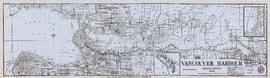
Vancouver Harbour, British Columbia, 1945
Part of City of Vancouver Archives technical and cartographic drawing collection
Item is a nautical chart showing English Bay and Burrard Inlet with soundings in feet, anchorages, locations of submarine cables, and ferry lines. Land features include city blocks and district lot numbers. Includes inset maps of the North Arm of Burrard Inlet and Vancouver Island. Note at the bottom of map states, "Not to be used for navigational purposes."

Vancouver Harbour, British Columbia, 1932
Part of City of Vancouver Archives technical and cartographic drawing collection
Item is a nautical chart showing English Bay and Burrard Inlet with soundings in feet, anchorages, locations of submarine cables, and ferry lines. Land features include city blocks and district lot numbers. Includes inset maps of the North Arm of Burrard Inlet and Vancouver Island.
Vancouver Harbour, British Columbia
Part of City of Vancouver Archives technical and cartographic drawing collection
Item is a nautical chart of Burrard Inlet, including the southern portions of the North Arm of Burrard Inlet. The map shows depth soundings, harbour anchorages, headlines, beacons, buoys, bells, piers and wharves. The map also shows lot numbers, municipal boundaries and major street names of the southern portion of North Vancouver and the northern portions of Point Grey, Kitsilano, Mt. Pleasant, Fairview, Hastings Townsite, Burnaby and Port Moody from the Coquitlam municipal boundary in the east to the western boundary of the Vancouver harbour (between Point Atkinson and Point Grey) in the west. The item also includes a key map showing the location of the Vancouver Harbour in relation to northwestern Washington and Vancouver Island and an inset map showing lots surrounding the north arm of Burrard Inlet to the Inlailawatash Indian Reserve.
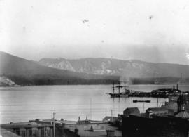
![Vancouver Harbour Sept. 1913 [showing the C.P.R. Station and yard and Pier D under construction]](/uploads/r/null/0/5/056455d9e690740168b8f4ae0d8d18b148b46061376f6b258e46b96ab0527cb1/82d16629-54f2-49c5-9a22-bf507e3921f0-A63186_142.jpg)
Vancouver Harbour Sept. 1913 [showing the C.P.R. Station and yard and Pier D under construction]
Part of Major Matthews collection
Vancouver Harbour [sectional map]
Part of City of Vancouver Archives technical and cartographic drawing collection
File contains 42 maps showing soundings, harbour headlines, high water marks, shore lines, shoals, submarine cable, rail lines and trails in the Vancouver area. Maps also show names of businesses and other structures.
![Vancouver Harbour from the Stadacona [Apartment Building]](/uploads/r/null/a/d/a/adad648f7aa2e6b96320fda8037a95ccb21b883a2daafadc021660a228ca983f/ab1ae707-0322-41fe-8c37-3456ba2ca84d-CVA289-038_142.jpg)
Vancouver Harbour from the Stadacona [Apartment Building]
Part of William Orson Banfield fonds
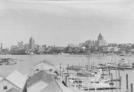
![Vancouver harbour from the roof garden [of David] Spencer's [Department] Store](/uploads/r/null/d/b/db5a883c9aac8bed679b57c2205d549efa86b2a28446fb64721146f1befa6a70/d5e169c6-2878-4aa0-ae91-fea056b71eac-CVA258-8_142.jpg)
Vancouver harbour from the roof garden [of David] Spencer's [Department] Store
Part of Hubert William Lovell fonds
Pier D, Empress of Russia, Deadman's Island and Brockton Point are visible in the distance. Photograph was taken in the summer.
Vancouver Harbour from Rowing Club, Stanley Park

Vancouver Harbour from Rowing Club, Stanley Park

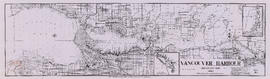
Vancouver Harbour. British Columbia
Part of City of Vancouver Archives technical and cartographic drawing collection
Item is a map sheet containing three nautical charts. The main map shows English Bay and Burrard Inlet and the land bordering these bodies of water, including North and West Vancouver, Downtown Vancouver, the University Endowment Lands and Port Moody. Inset maps depict the north arm of Burrard Inlet and a chart showing Vancouver Island in relation to the B.C. coast and the state of Washington, U.S.A.
Vancouver Harbour : sightseeing tours
"A trip that will linger long as a pleasant memory of Vancouver."

Vancouver Harbour : Sheet 3 (Second Narrows to Port Moody)
Part of City of Vancouver Archives technical and cartographic drawing collection
Item is a nautical chart of Vancouver Harbour from Second Narrows in the west to Port Moody in the east, showing soundings in fathoms, tidal information, anchorages, beacons, and waterfront businesses. Street names are shown on land areas.

Vancouver Harbour : Sheet 2 (Point Grey to Second Narrows)
Part of City of Vancouver Archives technical and cartographic drawing collection
item is a nautical chart of Burrard Inlet and Vancouver Harbour from Point Grey in the west to Second Narrows in the east, showing soundings in fathoms, tidal information, anchorages, beacons, and waterfront businesses. Street names are shown on land areas. A Royal Canadian Air Force bombing range at Jericho Beach is identified as a danger area.

Vancouver Harbour : Sheet 1 (First Narrows to Second Narrows)
Part of City of Vancouver Archives technical and cartographic drawing collection
Item is a nautical chart of Vancouver Harbour from First Narrows in the west to Second Narrows in the east, showing soundings in fathoms, tidal information, anchorages, beacons, and waterfront businesses. Street names are shown on land areas.
Vancouver Harbour : plan of south shore, Burrard Inlet between Heatley Ave. and Victoria Dr.
Part of City of Vancouver Archives technical and cartographic drawing collection
Item is a map which shows parcels of land along Burrard Inlet and district lots in downtown Vancouver. Piers, factories and mills along the waterfront are identified. Soundings are shown in feet.
National Harbours Board
Vancouver Harbour : plan of south shore, Burrard Inlet between Heatley Ave. and Victoria Dr.
Part of City of Vancouver Archives technical and cartographic drawing collection
Item is a map which shows parcels of land along Burrard Inlet and district lots in downtown Vancouver. Piers, factories and mills along the waterfront are identified. Soundings are shown in feet.

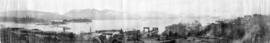
Panoramic view showing Burrard Inlet including 42 ocean steamers in port of which 25 were for grain cargoes, 17 vessels at berth (not shown in photograph) and the Harbour Commissioners wharf and Grain Elevator No. 1 and log booms

Part of City of Vancouver Archives technical and cartographic drawing collection
Item contains both nautical chart and map data. Nautical chart data includes soundings, anchorages, ferry lines, wharves, and waterfront businesses. Map features include district lots, streets, railways, and municipal boundaries.

Part of Major Matthews collection
Panoramic view showing Burrard Inlet including 42 ocean steamers in port of which 25 were for grain cargoes, 17 vessels at berth (not shown in photograph) and the Harbour Commissioners wharf and Grain Elevator No. 1 and log booms
Part of John William Freeston fonds
Panoramic view showing fuel oil tanks at the foot of Bute Street, Coal Harbour, the Vancouver Rowing Club, Deadmans Island, Brockton Point, the C.P.R. freight car ferry dock, the Immigration building, C.P.R. Pier A and Pender Street west of Burrard Street


Part of Major Matthews collection
Item is a photograph of a painting of the scene depicted in the image with the identifier SGN 155.
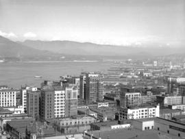
Vancouver from top of old Hotel Vancouver
Photograph shows a view looking northeast including the eastern docks

Vancouver from top of old Hotel Vancouver
Photograph shows a view looking north showing Pier B-C, the Main Post Office, the Royal Bank Building and ferries

Vancouver from top of old Hotel Vancouver
Photograph shows a view looking northeast

Part of City of Vancouver Archives sound recording and moving image collection
Item is a documentary film documenting Stanley Park, downtown Vancouver, the Vancouver Planetarium, and Vanier Park. The film documents a number of attractions within Stanley Park including the Stanley Park Miniature Railway, Stanley Park Junction, various sections of the seawall, the Brockton Point Lighthouse, Coal Harbour Marina, Elek Imredy's sculpture Girl in a Wetsuit, the replica figurehead of the RMS Empress of Japan, tennis courts, Prospect Point lookout, Lost Lagoon, the Stanley Park Golf Course, totem poles, and the Lions Gate (First Narrows) Bridge (1938-). The film also includes footage of birds including Canada geese, seagulls, swans, mallard and wood ducks, and peacocks. The film documents Vancouver Harbour and its facilities, and includes footage of shipping containers, cranes, cargo ships, seabus, and a floatplane.
The film also documents downtown Vancouver and includes footage of numerous prominent buildings including the Marine Building, Vancouver Harbour Centre, Bayshore Inn, the Westcoast Energy Building, Hotel Vancouver, the Provincial Court House, Robson Square under construction, the Georgia Medical Dental Building, the Bank of Nova Scotia Tower, TD Tower, the Vancouver Block, Commodore Ballroom, Sun Tower, Dominion Building, Andrew Wesley Church, and the Hudson's Bay Company building. The film also contains night footage of the Vancouver skyline, Granville Street with illuminated signs, a fountain lit by coloured lights, and neon signs in Chinatown, including those for the Marco Polo Chinese Smorgasbord, Loon Foon Kwok restaurant, Ming's, South Seas Dining Lounge, Ho Inn Chop Suey, and Bing C. Wong & Associates Accounting and Taxation Service.
Film also includes footage of the exterior of the Bloedel Conservatory, a tugboat in False Creek, the downtown Vancouver skyline as viewed from Kitsilano, an old house (number 1160, street unknown), sailboats in English Bay, the Vancouver Planetarium, Vanier Park, and Beach Avenue as seen across False Creek from Vanier Park.

Item is a photograph of an unidentified freighter loading lumber at a pier in Vancouver.
![[U.S.S. Mississippi in Burrard Inlet Harbour]](/uploads/r/null/6/b/6ba5565d65bc4816669751c59af21d30eb558178d1806fe895888c6554dc6f9a/d327bd52-9794-4f9e-99f9-b4bac801aeac-A00729_142.jpg)
[U.S.S. Mississippi in Burrard Inlet Harbour]
Part of Stuart Thomson fonds
Unique waterway of Canada's Pacific Coast
Item describes the exploration of a freshwater harbour on the Pacific Coast.
![[Unidentified harbour]](/uploads/r/null/6/8/e/68eebf2b470b00f76d1035ce8d44fb3511a0a7f9ef2df6d93ae2a142fe43d1da/b3562e2a-137e-405e-b1fb-ef92f25870b8-CVA260-1127_142.jpg)
Part of James Crookall fonds
![[Two boys watching boat enter Bull Harbour]](/uploads/r/null/e/f/ef96d3d9dfb3dcfe7f79214898e35aa876eda5260f5360b9b123ca3620bf651f/62f4ecf2-2cd4-4176-9222-7d45f15e67b5-A09300_142.jpg)
[Two boys watching boat enter Bull Harbour]
Part of Major Matthews collection
Photograph shows Peter and David McCallum, sons of Mr. and Mrs. Bruce McCallum at the radio weather station near Shushartic, B.C.
![Twilight anchorage [ship in harbour]](/uploads/r/null/0/7/0/070fcdba14a97229fe34dfd252185ba764db3a4c1c508cc33ded4cf07a8e200e/6db0a17a-a8a8-4177-8bd6-c2233df68cf4-CVA293-104_142.jpg)
Twilight anchorage [ship in harbour]
![Twilight anchorage [ship in harbour]](/uploads/r/null/4/9/2/4923632d88dba51cffecddb31cbfd4980f43232a820db1e148f7cd30c20a8970/510e5af0-3f17-4494-8174-f501decfbc32-CVA293-104_142.jpg)
Twilight anchorage [ship in harbour]
Part of City of Vancouver fonds
This item is a print of one of seven images created by graphic designer and artist David Hornblow for the City of Vancouver street banner series known as "Waterfront Images". This print depicts the bow of a tugboat and the loaded barge behind it.
Hornblow, David

Troopship from Korea, Vancouver, May 11/52
Item is a photograph of the USNS Private Sadao S. Munemori, a US naval transport vessel, docked in Vancouver Harbour. There is a tugboat in the foreground.

This postcard includes personal correspondence addressed to Mr. Arthur Baggs of Bath.
Tidal current charts : Vancouver Harbour, British Columbia
Part of City of Vancouver Archives technical and cartographic drawing collection
Item is a booklet containing twelve charts showing tidal currents in Vancouver Harbour at different points in the tidal cycle.