![Jericho #7 [8 of 34]](/uploads/r/null/f/3/9/f39662d2db057b3c84331004fdd38ba62f6630e880c44359393f860cacfc7fe0/8d250e95-c3ef-4437-add8-d4f8486e4934-CVA395-00217_142.jpg)
- AM1671-: CVA 395-00217
- Item
- [Oct. 31, 1975 or Nov.1, 1975]
Part of Habitat Forum photographs
221333 results with digital objects Show results with digital objects
Part of Habitat Forum photographs
![Jericho #7 [13 of 34]](/uploads/r/null/a/a/d/aadb5f0973ccbe57e57b585b8dcfcc2c05147598666f58fced4bfbd28fa4e864/9775809b-9a28-4e21-8d00-ed00446d873a-CVA395-00222_142.jpg)
Part of Habitat Forum photographs
![Jericho #7 [19 of 34]](/uploads/r/null/0/c/c/0ccde30e71b5279f2792b01ecee09be20befc6a5fb445370cb74f0127910b247/11ab165b-0235-4d9b-8cf8-065fc04e67c3-CVA395-00228_142.jpg)
Part of Habitat Forum photographs
![Jericho #7 [20 of 34]](/uploads/r/null/c/d/0/cd094c8646b386a0a040630fa9c02d80d4fc2620373018d73240f516dd3460f2/7411b5ee-8d5a-43f8-acd8-cdf097814a00-CVA395-00229_142.jpg)
Part of Habitat Forum photographs
![Jericho #7 [28 of 34]](/uploads/r/null/a/5/8/a58661eb0eb58ba13f358cb74e0a0707dba71faf770da795abc14d4242058b56/1db42ffb-d26b-4f9e-897c-6cfb298926a3-CVA395-00237_142.jpg)
Part of Habitat Forum photographs
![Jericho #7 [6 of 34]](/uploads/r/null/3/b/d/3bd242ef6484670d3b118519a3f99d65464df88ad44bb0e7835d988083b1337d/e45fc92a-0759-4232-b507-94088b32e3c9-CVA395-00215_142.jpg)
Part of Habitat Forum photographs
![Jericho #7 [7 of 34]](/uploads/r/null/b/5/e/b5ed2a70990d2d08ccdf535e971a7b0b8cf4d58538e8efd03ffac21013cbb101/f9de0cb5-86b9-4552-af7f-3f6092d710bb-CVA395-00216_142.jpg)
Part of Habitat Forum photographs
![Jericho #7 [9 of 34]](/uploads/r/null/1/5/9/159e7de7aa10a7703841c8ee9a8ffaa2ed1e2281c110e43105b8d9903e3a0eba/fb5875c0-7d29-4f33-a48e-cbec0ca257ff-CVA395-00218_142.jpg)
Part of Habitat Forum photographs
![Jericho #7 [14 of 34]](/uploads/r/null/6/9/4/694b9d2044bd5d02626d372f883f16d1179ca7207e5fc938fbdc51c25b82aa42/2484de64-8b30-4e64-b2cf-d04947b061f1-CVA395-00223_142.jpg)
Part of Habitat Forum photographs
![Jericho #7 [16 of 34]](/uploads/r/null/1/a/5/1a58f208318605a20206508610b9ded54e834d38b4e241a1d9895880362b29b9/0c61fec0-8e57-42b3-b50b-d40f1784df79-CVA395-00225_142.jpg)
Part of Habitat Forum photographs
![Jericho #7 [23 of 34]](/uploads/r/null/6/3/d/63d211666831adf306e274c02f8e96527a9b59d63b5bfb3eae19056b0cf31f0e/c9c0daf0-05bf-409a-a96a-4366d13f5bf0-CVA395-00232_142.jpg)
Part of Habitat Forum photographs
![Jericho #7 [26 of 34]](/uploads/r/null/7/c/9/7c95572a5c824e5b49eb64a6341d5599b90b8b667658bca618b1c11eb58668de/2b2facef-4efe-496e-ba45-fad9602cf98b-CVA395-00235_142.jpg)
Part of Habitat Forum photographs
![Jericho #7 [31 of 34]](/uploads/r/null/f/c/5/fc56bc9c3dfe24ec489474581cb79ed64f723931cac3faffa54a67fa0fb27a5c/75b4dad8-9735-41a7-bf2d-b01f08bb1f76-CVA395-00240_142.jpg)
Part of Habitat Forum photographs
![Jericho #7 [32 of 34]](/uploads/r/null/6/8/f/68f385d1ab71eb18d4ce8fcf6f1b5e6d1c31096a4dd1ecef11855830fc053c36/9410c60d-8505-47c3-913f-13b9fe2a7cf6-CVA395-00241_142.jpg)
Part of Habitat Forum photographs
Playboard : the lively arts and entertainment magazine

Map of the town of Coevorden (portion)
Part of Adrien Mansvelt collection
Item is a reproduction of part of a map showing the location of the town of Coervorden, Netherlands and surrounding area.
van Deventer, Jacob

Zelfportret by Isaac Claesz van Swanenburg
Item is a photographic reproduction of Zelfportret by Isaac Claesz van Swanenburg.

Sicilian mill ca. 1600, the Mansell Collection

A portion of a map showing the coasts of Peru and Chile
Part of City of Vancouver Archives technical and cartographic drawing collection
Item is a photographic reproduction of a portion of a map of the Americas, depicting the Pacific coasts of South America.

Nova totius terrarum orbis geographica ac hydrographica tabula
Part of City of Vancouver Archives technical and cartographic drawing collection
Item is a reproduction of a geographical and hydrographical map of the world created in 1621.
The collection consists of a warrant from the "Committee of Plundered Ministers" directing the payment of six pounds [sterling] to Gabriel Wilkinson, minister of the Parish Church at Woobourne, Bucks., dated 23 March 1651.
Aubrey Place sewer construction wye sheets
Part of City of Vancouver fonds
Vancouver (B.C.). Water and Sewers Division
A trve and exact history of the Island of Barbados...
Volume is a published history of the Island of Barbados, and includes information on sugar refining.
Part of Phyllis Ross fonds
A map from the first comprehensive atlas of Scotland, published by Joan Blaeu, Amsterdam. Latin text on verso.

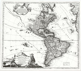
Nova totius Americae descriptio
Part of City of Vancouver Archives technical and cartographic drawing collection
Item is a reproduction of a map depicting North America, Central America and South America.
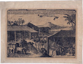
Sucreries du Bresil. Brasilise suyker werken
Item consists of a seventeenth century engraving of a sugar plantation in Brazil, including notes on various growing, harvesting and refining activities depicted.

Water powered cane mill, West Indies
Map of the world, western continent undiscovered
Part of Major Matthews collection
Map of the world, west coast of Canada still unknown
Part of Major Matthews collection

A new map of the terraqueous globe
Part of City of Vancouver Archives technical and cartographic drawing collection
Item is a world map depicting the rough outlines of continents, rivers and other geographical features. The map is bordered with inset drawings and include the following dedication: "Dedicated to his Highness, William Duke of Gloucester".
Part of City of Vancouver Archives technical and cartographic drawing collection
Item is a reproduction of a map depicting North American and South America.
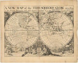
A new map of the terraqueous globe
Part of City of Vancouver Archives technical and cartographic drawing collection
Item is a world map depicting the rough outlines of continents, rivers and other geographical features. The map is bordered with inset drawings and include the following dedication: "Dedicated to his Highness, William Duke of Gloucester".
A kind of honey: Original pages from a 1749 magazine article on sugar
New England Colonies, 1754, from Gentleman's Magazine
Part of Major Matthews collection
North West Passage, 1592, 1603 Strait of Juan De Fuca
Part of Major Matthews collection
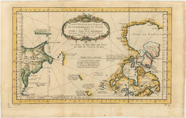
Part of City of Vancouver Archives technical and cartographic drawing collection
Item is a map engraved by French cartographer M. Bellin showing eastern Asia and the northern part of North America, mainly Canada. Includes notes as to areas of the west coast of North America explored by the Russians in 1728 and 1741, the exploration of the entrance of the Strait of Juan de Fuca in 1592 and 1603, as well as exploration on the east coast of Asia. Map also includes latitudes and longitudes, some place names, major bodies of water and indicates mountainous regions. Printed on the bottom of the map is "Tome XV" and "No. 4."
Wolfe, James, photostat of letter written in 1758, Carleton & Vancouver specimens
Part of Major Matthews collection

Part of Major Matthews collection
North West Passage, early map of, 1760, route to Europe
Part of Major Matthews collection
Volume is a published monograph on the technology and methods of sugar refining in the tropical colonies of Spain, England and France.
Plan depicts: outboard profile, inboard profile, lines plan, body plan, and deck plan.
Plan depicts: plan view.
Part of Major Matthews collection
Item consists of a photographic copy of Benjamin West's painting The Death of General Wolfe, presented to J.S. Matthews by Marjorie Wade.
Marquis of Granby (Endeavour) - bark
Plan depicts: outboard profile, inboard profile, and body plan.
Plan depicts: outboard profile, inboard profile, and body plan.

The asiatic part of the Russian empire
Part of City of Vancouver Archives technical and cartographic drawing collection
Item is a map sheet which appears to be a part of a map of Russia. The sheet depicts the area immediately around Lake Baikal, to the north coast and east to the Pacific, including the islands of the north-west Pacific.