
Aerial photo, vertical, University of British Columbia and University Endowment Lands
- AM1376-: CVA 59-15
- Item
- May 1956
Aerial photo, vertical, University of British Columbia and University Endowment Lands
![[Aerial photograph of University of British Columbia Endowment Land area, showing some farm land]](/uploads/r/null/7/0/70e1f604470000e7a05baa46d299f27cb13e52173626249485a3a2586cb9f054/90b2a170-3763-41e7-a2ac-edba3984d880-A72733_142.jpg)
[Aerial photograph of University of British Columbia Endowment Land area, showing some farm land]
Part of Dunbar History Project fonds
Item filed under People and customs. Image shows Department of Agriculture farm.
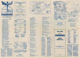
Part contains street maps of the University Endowment Lands, Surrey, Maillardville, Lulu Island and Sea Island, tourist information about Vancouver, and text advertising the products and services of the Dominion Map and Blueprint Company.

Part of City of Vancouver Archives technical and cartographic drawing collection
Part contains street maps of the University Endowment Lands, Surrey, Maillardville, Lulu Island and Sea Island, tourist information about Vancouver, and text advertising the products and services of the Dominion Map and Blueprint Company.
![[The last Spanish exploration - Historic Site and Monuments Board of Canada monument]](/uploads/r/null/7/2/a/72a3937c686e9bd484c592e1e6a4389a5d3a7285f049b4000886b1c5f6778c1f/d54612a7-d7da-4ebc-8170-6514bdc5ec3f-CVA1095-01082_142.jpg)
[The last Spanish exploration - Historic Site and Monuments Board of Canada monument]
Part of City of Vancouver fonds
Item is a photograph showing a plaque and monument located on Northwest Marine Drive.
![[The last Spanish exploration - Historic Site and Monuments Board of Canada plaque]](/uploads/r/null/1/a/4/1a42dfc3b8e87a65a11d0d1110d245ab06ade80a59d37f918aa515458b2cfdab/4a127ad1-c6fb-4285-ade9-f0b5965ab2b6-CVA1095-01081_142.jpg)
[The last Spanish exploration - Historic Site and Monuments Board of Canada plaque]
Part of City of Vancouver fonds
Item is a photograph showing a plaque on a monument located on Northwest Marine Drive.

University Endowment Lands : plan of units no. 1 and 2
Part of City of Vancouver Archives technical and cartographic drawing collection
Item is a map showing streets, land subdivision, properties disposed of, and buildings in the University Endowment Lands north of University Boulevard. Additional blocks have been filled in by hand, likely by J.S. Matthews.

University Endowment Lands : plan of units nos. 1 and 2
Part of City of Vancouver Archives technical and cartographic drawing collection
Item is a map showing streets, land subdivision, properties disposed of, and buildings in the University Endowment Lands north of University Boulevard. Telephone numbers have been changed, issuing date added, and additional blocks filled in by hand, likely by J.S. Matthews.
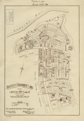
University Endowment Lands : plan of units nos. 1 and 2
Part of City of Vancouver Archives technical and cartographic drawing collection
Item is a map showing streets, land subdivision, properties disposed of, and buildings in the University Endowment Lands north of University Boulevard. Additional blocks have been filled in by hand, likely by J.S. Matthews.