
Canadian Traffic Signal Corporation - Photo of New Signals
- AM1535-: CVA 99-3644
- Item
- 1929
Part of Stuart Thomson fonds
Photograph shows Marine Drive at Heywood Park
Canadian Traffic Signal Corporation - Photo of New Signals
Part of Stuart Thomson fonds
Photograph shows Marine Drive at Heywood Park

City and District of North Vancouver
Part of City of Vancouver Archives technical and cartographic drawing collection
Item is a map showing the city and district of North Vancouver. It shows paved roads, gravel roads, unopened roads and a graphical depiction of the population as of 1947. A small inset map shows the position of the city of North Vancouver and the district of North Vancouver in relation to Vancouver, Burrard Inlet and West Vancouver. Annotations appear to be in J.S. Matthews' hand, noting a portion of North Vancouver as "King's Lynn".

Part of City of Vancouver Archives technical and cartographic drawing collection
Map shows Vancouver from West Boulevard to Boundary Road and from Burrard Inlet to the Fraser River. A portion of North Vancouver is also shown. Streets, parks, schools and golf courses are identified. Map joins with MAP 575 to create a complete map of the City of Vancouver.

Dial map of Greater Vancouver and suburbs
Part of City of Vancouver Archives technical and cartographic drawing collection
Part contains a street map of Vancouver, Burnaby, New Westminster, West Vancouver and North Vancouver showing block numbers, street car, bus, and railway lines, parks and hospitals. Map includes two dials (a numbered circle, a paper indicator, a grid of block numbers and a street index used to find locations). A small inset map shows the Capitol Hill/Scenic Park area of Burnaby in greater detail.

Dial map of Greater Vancouver and suburbs
Part of City of Vancouver Archives technical and cartographic drawing collection
Part contains a street map of Vancouver, Burnaby, New Westminster, West Vancouver and North Vancouver showing block numbers, street car, bus, and railway lines, parks and hospitals. Map includes two dials (a numbered circle, a paper indicator, a grid of block numbers and a street index used to find locations). A small inset map shows the Capitol Hill/Scenic Park area of Burnaby in greater detail.

Dial map of Greater Vancouver and suburbs
Part of City of Vancouver Archives technical and cartographic drawing collection
Part contains a street map of Vancouver, Burnaby, New Westminster, West Vancouver, and North Vancouver showing railways, hospitals, parks and block numbers. The map includes two dials (numbered circles, paper indicators, a grid of block numbers and a street index used to find locations).
![[Fairmont Road washed out after the storm]](/uploads/r/null/f/d/fdac97656d097c1db744ea7ebff607ce140d236c2c466c08c6de0f6317783415/616b630a-7f25-40f6-9722-b0b838b2a7aa-A33735_142.jpg)
[Fairmont Road washed out after the storm]
Part of Major Matthews collection

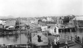
Ferry landing and Lonsdale Ave., North Vancouver
![[Ferry line-up extends down Lonsdale Ave. from 8th St.]](/uploads/r/null/3/6/367ef713063c6e5458ccbd6abe9202e417d4a8156909c4fb1e3a7c2baada4cdc/daa5f6ad-1e38-4e0a-9038-59cfd6cd1edc-A24498_142.jpg)
[Ferry line-up extends down Lonsdale Ave. from 8th St.]
Part of Major Matthews collection
![[Ferry line-up on Lonsdale Avenue up to Eighth Street]](/uploads/r/null/0/7/07c1d194551657a593def712e867cd96259b6e82559677fc17d0b3c0ceceb28d/88726415-08cd-4424-9062-15ff90ff2cdf-A24499_142.jpg)
[Ferry line-up on Lonsdale Avenue up to Eighth Street]
Part of Major Matthews collection

Ferry Wharf North Vancouver, B.C.
Part of Major Matthews collection
![[Fifteenth Street looking east towards Grand Boulevard]](/uploads/r/null/7/3/73a89135f77f03c2170bc52234ba67e4d5b33dd68391be03e9ca3753fb8abd65/1332756e-55c4-4d2a-93f8-9e02d7c4bc28-A33961_142.jpg)
[Fifteenth Street looking east towards Grand Boulevard]
Part of Major Matthews collection
![[Foot of Lonsdale Avenue from ferry terminal]](/uploads/r/null/b/b/bb495757dd002adb23951152985e71388ce81c70ee373cf6557f1e8f7f203b16/b14d2b0d-a70b-4a21-b634-f75d1d883e1e-A02676_142.jpg)
[Foot of Lonsdale Avenue from ferry terminal]
Photograph shows Lonsdale Street, looking north, as well as pedestrians, carriages, and some buildings.

Part of Major Matthews collection
![[Looking north along Lonsdale Avenue from the ferry wharf]](/uploads/r/null/1/e/1ef12d281e91fc1c1a49a731cfc31bb1cf33747b5be716973e17e8f0372b7a3f/319fd277-2b1f-4626-994b-3063bae557af-A62579_142.jpg)
[Looking north along Lonsdale Avenue from the ferry wharf]
Part of Major Matthews collection

Part consists of a street map of the Lower Mainland and Fraser Valley from Vancouver to Chilliwack, a street map of New Westminster, a map of Vancouver and North Vancouver showing street names but not street lines, and text advertising the products and services of the Dominion Map and Blueprint Company.

Part of City of Vancouver Archives technical and cartographic drawing collection
Part contains an illustrated map of West Vancouver and North Vancouver showing major streets, mountains, rivers and creeks, and recreational attractions; a street index to the Greater Vancouver map on the other side of the sheet; a list of golf courses; and real estate information including a description of professional realtors, an amortization table, and calculations showing amounts paid in rent over many years.

Map of West Vancouver and vicinity
Part of City of Vancouver Archives technical and cartographic drawing collection
Part contains a map of West Vancouver, North Vancouver, and the northern parts of Vancouver and Burnaby. Map shows district lot and block numbers, streets, and distances from City Hall.
![[Moody Avenue and Seventh Street]](/uploads/r/null/4/a/4a47ba26ff022cbedb4c458cdaae1313c7d362a053c46d9cee5234510d242e07/35244082-830d-4917-8d46-0e6df8091c1d-A09195_142.jpg)
[Moody Avenue and Seventh Street]
Part of Major Matthews collection
Photograph shows street sign amongst tree stumps in partially cleared land.
![North Shore Marine Drive [and] Point Atkinson, Vancouver, B.C., Canada](/uploads/r/null/b/3/1/b31126992eefcb817ddcd71e986e554566c5a7384d9b78337c6b98c541189b86/86aad77d-e1bb-4799-b9d0-da385dffbff1-AM1052P-2170_142.jpg)
North Shore Marine Drive [and] Point Atkinson, Vancouver, B.C., Canada
Part of Major Matthews collection
Photograph shows the ferry landing and Lonsdale Avenue
![[Northern view of Lonsdale Avenue]](/uploads/r/null/0/0/004f60b942e23702aaee6204aee266b4ad516e517df3f70971bf02819643b669/ae2e7cc4-bbec-4154-a6e4-c8fbf58beb95-A26824_142.jpg)
[Northern view of Lonsdale Avenue]
Part of Major Matthews collection
![[Northern view of Lonsdale Avenue from the ferry dock]](/uploads/r/null/2/a/2a7bb34b044a9f06e963b6af0e946ceb80777fcb87e3c08a59497c37a76f46fd/b72e1250-2f39-4a4a-91ff-3088c0f00501-A26823_142.jpg)
[Northern view of Lonsdale Avenue from the ferry dock]
Part of Major Matthews collection

Street index (Gibson Street to William Street) and tram stations
Part of City of Vancouver Archives technical and cartographic drawing collection
Part is a page from the booklet accompanying a guide map of Greater Vancouver, and contains the last portion of the North Vancouver street index, the West Vancouver street index, and a list of Vancouver tram stations.

Street index (Royal Oak Avenue, Vancouver to Frederick Road, North Vancouver)
Part of City of Vancouver Archives technical and cartographic drawing collection
Part contains two pages from the booklet accompanying a guide map of Greater Vancouver. Pages include the last portion of the Vancouver and Burnaby street index, the New Westminster street index, and the North Vancouver street index from 1st Street to Frederick Road.