Diary of significant events in the history of B.C. Electric's Transportaion System, 1889 - 1946.
- HE 311 .C32 V3785 1947a
- [1947]
76 results with digital objects Show results with digital objects
Diary of significant events in the history of B.C. Electric's Transportaion System, 1889 - 1946.
133 Keefer Street, Vancouver, B.C. [Rifle and Revolver Range]
Part of City of Vancouver fonds
File consists of architectural drawings of a proposed rifle and revolver range to be built at Lot 17 Blk 15 DL 196. The drawings depict an site plan, floor plan, elevations, sections and details.
5725 Dunbar Street, Vancouver, B.C. [B.C. Electric Southlands Substation]
Part of City of Vancouver fonds
File consists of an architectural drawing of the B.C. Electric substation, located at the south-west corner of West 41st Avenue and Dunbar Street. The drawing depicts floor plans, elevations and sections.
420 Templeton Drive, Vancouver, B.C. [B.C.E.R. East Hastings Substation]
Part of City of Vancouver fonds
File consists of architectural drawings of the Vancouver East Hastings substation, located at Lot No. 1 Blk 44 DL 184. The drawings depict a block plan, floor plans, elevations, sections and details.
South foot of Carrall Street, Vancouver, B.C. [Carrall Street Gas Works]
Part of City of Vancouver fonds
File consists of architectural drawings of various structures at Carrall Street Gas Works of the B.C.E. Power and Gas Company, located at the south end of Carrall Street at False Creek. The drawings depict site plans, piling plans, foundation plans, cross sections, elevations, floor plans, details and schedules.

Transit detail inset maps ; Street index ; Transit and tourist information
Part consists of three maps showing transit details in Richmond, New Westminster and downtown Vancouver, and descriptive information about B.C. Electric routes and services and Greater Vancouver attractions.

Transit system map of Greater Vancouver, B.C.
Part consists of a map showing trolley coach lines, bus lines, street car lines, interurban lines, interurban stops, route numbers, B.C. Electric installations and block numbers in West Vancouver, North Vancouver, Vancouver, Burnaby and the University Endowment Lands.
Item is a map and transit guide showing trolley coach lines, bus lines, street car lines, interurban lines, interurban stops, route numbers, B.C. Electric installations and block numbers in West Vancouver, North Vancouver, Vancouver, Burnaby and the University Endowment Lands one one side. The other side consists of three maps showing transit details in Richmond, New Westminster and downtown Vancouver, and descriptive information about B.C. Electric routes and services and Greater Vancouver attractions.

Bus routings in the downtown area
Part contains textual information about bus routes and services.

Composite map of B.C. Electric downtown bus routes
Part shows bus routes from Burrard Inlet in the north to False Creek in the south and from Main Street in the east to Thurlow in the west.
Composite map of B.C. Electric downtown bus routes
Item is a map showing bus routes in downtown Vancouver on one side and textual information on bus routes on the other.

Part of City of Vancouver Archives technical and cartographic drawing collection
Part contains maps of the Richmond and downtown Vancouver transit systems, a street index to the Greater Vancouver map on the other side of the sheet, information on B.C. Electric transit routes, and general tourist information.

Transit system map of Greater Vancouver, B.C.
Part of City of Vancouver Archives technical and cartographic drawing collection
Part contains a map of Greater Vancouver showing bus lines, route numbers, B.C. Electric installations, block numbers, points of interest and amenities; an inset map showing streets in Gleneagles, Whytecliff, and Horseshoe Bay; and an inset map showing streets in Port Moody, Coquitlam, and Maillardville.
B.C. Electric guide to Greater Vancouver
Part of City of Vancouver Archives technical and cartographic drawing collection
Item is a pamphlet containing transit maps covering Greater Vancouver and Richmond, as well as textual information on bus routes and points of interest in Vancouver.

Part of City of Vancouver Archives technical and cartographic drawing collection
Part contains maps of the Richmond and downtown Vancouver transit systems, a street index to the Greater Vancouver map on the other side of the sheet, information on B.C. Electric transit routes, and general tourist information.

Transit system map of Greater Vancouver, B.C.
Part of City of Vancouver Archives technical and cartographic drawing collection
Part contains a map of Greater Vancouver showing bus lines, route numbers, B.C. Electric installations, block numbers, points of interest and amenities; an inset map showing streets in Gleneagles, Whytecliff, and Horseshoe Bay; and an inset map showing streets in Port Moody, Coquitlam, and Maillardville.
B.C. Electric guide to Greater Vancouver
Part of City of Vancouver Archives technical and cartographic drawing collection
Item is a pamphlet containing transit maps covering Greater Vancouver and Richmond, as well as textual information on bus routes and points of interest in Vancouver.
Part of City of Vancouver Archives technical and cartographic drawing collection
Part contains B.C. Electric logo and J.S. Matthews's annotations regarding the plan.

B.C. Electric Rly. Co. Ltd. plan showing transit services in Vancouver city as at end of 1951
Part of City of Vancouver Archives technical and cartographic drawing collection
Part is a map showing existing and proposed transit lines in Vancouver.
B.C. Electric Rly. Co. Ltd. plan showing transit services in Vancouver city as at end of 1951
Part of City of Vancouver Archives technical and cartographic drawing collection
Item is a transit map of Vancouver showing existing and proposed service routes under the three year transit modernization plan for years 1948-1951.
B.C. Electric guide to Greater Vancouver
Part of City of Vancouver Archives technical and cartographic drawing collection
Item is a transit guide in the form of a brochure. On the exterior side of the unfolded sheet is information about BC Electric routes, points of interest in the city, and smaller inset maps. The principal map is on the verso.

B.C. Electric sub-station at Second Narrows Bridge

B.C. Electric sub-station at Second Narrows Bridge

B.C. Electric sub-station and electric towers at Second Narrows Bridge

B.C. Electric sub-station and electric towers at Second Narrows Bridge

Photograph shows men filling sacks

Photograph shows men checking guages
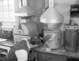
Photograph shows a man checking a machine

Photograph shows a woman checking guages


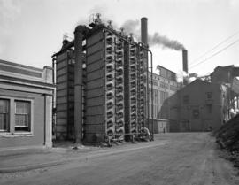
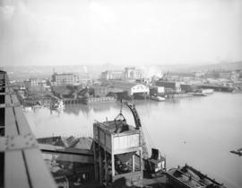
Oblique view of the plant


Photograph shows the Canadian National Railway Station in the background


![B.C. Electric [photographs for the] Story of Gas](/uploads/r/null/a/d/ada954903c872e27e9de15b5f7f7561f5bd2800cb40c69049aca5a3062896355/d932b7fb-7b6d-4761-9dde-8d06a96e4a27-A15271_142.jpg)
B.C. Electric [photographs for the] Story of Gas
![B.C. Electric [photographs for the] Story of Gas](/uploads/r/null/4/1/41f3e087346260dfa2d60cc2887272d12fee102c165dd756a3607fef8bfda611/f98b159e-eeed-416f-a3fa-1e9d41bec5aa-A15270_142.jpg)
B.C. Electric [photographs for the] Story of Gas
![B.C. Electric [photographs for the] Story of Gas](/uploads/r/null/2/4/245b217f682087b02aed1f00e291e0733bb954a9fdbb7d2e680cfa2d593947d3/add8343a-e005-463e-985d-266bb60c1bc1-A06434_142.jpg)
B.C. Electric [photographs for the] Story of Gas
![B.C. Electric [photographs for the] Story of Gas](/uploads/r/null/0/c/0c5918cec08d70e3fc027840b6d469b51bd566fb90145c5cad5f779a606efb9c/5b9d3b39-3e26-488a-88aa-08241563f01b-A15269_142.jpg)
B.C. Electric [photographs for the] Story of Gas
![B.C. Electric [photographs for the] Story of Gas](/uploads/r/null/a/e/ae904c3fc0f1e47537406b9446f9688cb762c2b7eec1f9210a01f5bae497f6dc/8cedbc73-71cc-4660-b7ec-902fa645bb33-A15268_142.jpg)
B.C. Electric [photographs for the] Story of Gas
![B.C. Electric [photographs for the] Story of Gas](/uploads/r/null/0/0/0056aaeb3414c6e3ffbaed69f564cac36792b9bd7227cbc6b514a9f11cbbaf9d/7c9b7913-5b8c-48f8-a0da-62da0f0231ae-A06433_142.jpg)
B.C. Electric [photographs for the] Story of Gas
![B.C. Electric [photographs for the] Story of Gas](/uploads/r/null/a/b/abde002b5dacd26c3e3dc63efa784a23df9809d959573df681a5cfa1cbce25d3/1716b3e1-c6ab-428b-9e20-fda01dc54589-A06432_142.jpg)
B.C. Electric [photographs for the] Story of Gas
![B.C. Electric [photographs for the] Story of Gas](/uploads/r/null/8/5/8546a188cb5324bae79319401829ff5a8a70fe586d687f2383bd671ea90e893b/1122e4f3-74b5-4be7-a0ce-566b98853e06-A15267_142.jpg)
B.C. Electric [photographs for the] Story of Gas
![B.C. Electric [photographs for the] Story of Gas](/uploads/r/null/0/1/019412d2da23829692b7ad413ea457c9f3a37a6b9e075adef6198d726e00da50/83e75f15-1945-4100-9920-4a564e862db8-A06431_142.jpg)
B.C. Electric [photographs for the] Story of Gas
![B.C. Electric [photographs for the] Story of Gas](/uploads/r/null/3/2/32581d725f5afaa2fc6469b0309f63abd70175959603a06bc0b18281319fc14e/0c38e809-3bb4-4b07-a914-505c31384e22-A06430_142.jpg)
B.C. Electric [photographs for the] Story of Gas