- COV-S697--
- File
- June 1968
Part of City of Vancouver fonds
Vancouver (B.C.). Engineering Services
1031 results with digital objects Show results with digital objects
Part of City of Vancouver fonds
Vancouver (B.C.). Engineering Services
Water works register of appropriations for roadwork
Part of City of Vancouver fonds
Series consists of a register listing all instances of roadwork, drainwork, etc. It is possible to determine the date of the work, the portion of a street for which work was completed, and the cost of the work by looking up a street name. The date sequence appears complete. Arranged alphabetically by street name.
Vancouver (B.C.). Water Works Department
Water works distributing journals
Part of City of Vancouver fonds
Series consists of accounting records of the Waterworks Dept., including administrative and operational expenses. 1929-1933 records are missing. After 1933 the record is called "Distributing Journal". Arranged chronologically.
Vancouver (B.C.). Water Works Department
Water supply development records
Part of City of Vancouver fonds
Series consists of maps, plans and profiles of the Vancouver water supply system and the area which supplies the system. Included are detailed technical drawings of pipes, joints and the mechanical systems. There are also a number of maps of the North Vancouver creeks which supply the water system. A third group are linen drawings of tenders, submitted for pipes and other materials in the system. Lastly, there are engineering profiles of the creeks involved in the system.
Vancouver (B.C.). Water Works Department
Part of City of Vancouver fonds
Vancouver (B.C.). Engineering Services
Part of City of Vancouver fonds
Series consists of a variety of records relating to the planning, designing, and opening of Vancouver's bridges. Included are plans for the Connaught Bridge (1910) and the Burrard Street Bridge (1930-1931), Granville Street Bridge (1952), photographs of the Granville Street Bridge (1954), and motion picture films on the building of the Granville Street Bridge (1954) and the Cambie Street Bridge (1986). Filing units arranged chronologically by start date.
Vancouver (B.C.). Engineering Services
Transportation Planning Engineer Expo 86 files
Part of City of Vancouver fonds
Series consists of correspondence, informal reports, City reports, consultants' reports, notes to file, minutes of the Transportation Working Group and the Expo Traffic Operations Group, and architectural drawings of sites, relating to transportation and traffic planning activities of committees of Provincial, Expo, and City officials for Expo 86. Textual records arranged chronologically; oversize maps and architectural drawings are a separate chronological sequence.
Vancouver (B.C.). Engineering Services
Part of City of Vancouver fonds
Vancouver (B.C.). Engineering Services
Technical report no.5 : The variable working times demonstration
Part of City of Vancouver fonds
Vancouver (B.C.). Engineering Services
Technical report no. 6 : Overall project review
Part of City of Vancouver fonds
Vancouver (B.C.). Engineering Services
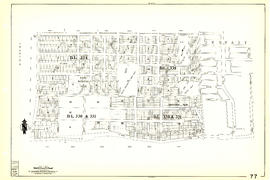
Sheet 90 : Carrington Street to Macdonald Street and Richmond to Celtic Avenue
Part of City of Vancouver Archives technical and cartographic drawing collection
Item is a section showing streets and blocks in the area from Carrington Street to Macdonald Street and Richmond to Celtic Avenue.
Vancouver (B.C.). Engineering Services

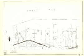
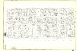
Sheet 9 : Main Street to Clark Drive and Prior Street to Burrard Inlet
Part of City of Vancouver Archives technical and cartographic drawing collection
Item is a section showing the area from Main Street to Clark Drive and Prior Street to Burrard Inlet. Includes streets, blocks, lots and legal descriptions, and the locations of parks, schools, railways and piers along the waterfront.
Vancouver (B.C.). Engineering Services

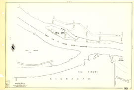
Sheet 89 : North Arm of Fraser River to Southwest Marine Drive and Barnard Street
Part of City of Vancouver Archives technical and cartographic drawing collection
Item is a section showing the area from North Arm of Fraser River to Southwest Marine Drive and Barnard Street. Includes streets, blocks, lots and legal descriptions.
Vancouver (B.C.). Engineering Services

Sheet 88 : Macdonald Street to Angus Drive and Edgington Avenue to Fifty-seventh Avenue
Part of City of Vancouver Archives technical and cartographic drawing collection
Item is a section showing the area from Macdonald Street to Angus Drive and Edgington Avenue to Fifty-seventh Avenue. Includes streets, blocks, lots and legal descriptions, and the locations of schools, parks and golf courses.
Vancouver (B.C.). Engineering Services

Sheet 87 : Barnard Street to Heather Street and Beckwith Road to Seventy-fifth Avenue
Part of City of Vancouver Archives technical and cartographic drawing collection
Item is a section showing the area from Barnard Street to Heather Street and the North Arm of the Fraser River to Seventy-fifth Avenue. Includes streets, blocks, lots and legal descriptions, and the locations of schools and parks. Also Includes streets and blocks in Richmond from Beckwith Road to River Drive.
Vancouver (B.C.). Engineering Services

Sheet 86 : Angus Drive to Laurel Street and Seventy-fifth Avenue to Sixty-seventh Avenue
Part of City of Vancouver Archives technical and cartographic drawing collection
Item is a section showing the area from Angus Drive to Laurel Street and Seventy-fifth Avenue to Sixty-seventh Avenue. Includes streets, blocks, lots and legal descriptions, and the locations of schools and parks.
Vancouver (B.C.). Engineering Services

Sheet 85 : Laburnum Street to Fremlin Street and Sixty-eighth Avenue to Fifty-seventh Avenue
Part of City of Vancouver Archives technical and cartographic drawing collection
Item is a section showing the area from Laburnum Street to Fremlin Street and Sixty-eighth Avenue to Fifty-seventh Avenue. Includes streets, blocks, lots and legal descriptions, and the locations of schools and parks.
Vancouver (B.C.). Engineering Services

Sheet 84 : Laurel Street to Main Street and North Arm of Fraser River to Southwest Marine Drive
Part of City of Vancouver Archives technical and cartographic drawing collection
Item is a section showing the area from Laurel Street to Main Street and North Arm of the Fraser River to Southwest Marine Drive. Includes streets, blocks, lots and legal descriptions, and the location of the Canadian Pacific Railway line and yard.
Vancouver (B.C.). Engineering Services

Sheet 83 : Fremlin Street to Main Street and Southwest Marine Drive to Fifty-seventh Avenue
Part of City of Vancouver Archives technical and cartographic drawing collection
Item is a section showing the area from Fremlin Street to Main Street and Southwest Marine Drive to Fifty-seventh Avenue. Includes streets, blocks, lots and legal descriptions, and the locations of schools, parks and hospitals.
Vancouver (B.C.). Engineering Services

Part of City of Vancouver Archives technical and cartographic drawing collection
Item is a section showing the area from Main Street to Tipping Road and Crompton Street and Twigg Island to Southeast Marine Drive. Includes streets, blocks, lots and legal descriptions, and the location of the Canadian Pacific Railway.
Vancouver (B.C.). Engineering Services

Sheet 81 : Main Street to Inverness Street and Southeast Marine Drive to Fifty-seventh Avenue
Part of City of Vancouver Archives technical and cartographic drawing collection
Item is a section showing the area from Main Street to Inverness Street and Southeast Marine Drive to Fifty-seventh Avenue. Includes streets, blocks, lots and legal descriptions, and the locations of schools and parks.
Vancouver (B.C.). Engineering Services
Part of City of Vancouver Archives technical and cartographic drawing collection
Item is a section showing the area from Tipping Road, Crompton Street and Inverness Street to Gladstone Street and Mitchell Road to Sixty-first Avenue. Includes streets, blocks, lots and legal descriptions.
Vancouver (B.C.). Engineering Services
Sheet 8 : Main Street to Clark Drive and Alexander Street to Burrard Inlet
Part of City of Vancouver Archives technical and cartographic drawing collection
Item is a section showing the area from Main Street to Clark Drive and Alexander Street to Burrard Inlet. Includes streets and blocks, railways, piers and leases along the waterfront.
Vancouver (B.C.). Engineering Services

Sheet 79 : Gladstone Street to Kerr Street and North Arm of Fraser River to Bobolink Avenue
Part of City of Vancouver Archives technical and cartographic drawing collection
Item is a section showing the area from Gladstone Street to Kerr Street and North Arm of Fraser River to Bobolink Avenue. Includes streets, blocks, lots and legal descriptions, and the locations of schools, golf courses and the Canadian Pacific Railway.
Vancouver (B.C.). Engineering Services

Sheet 78 : Kerr Street to Ivy Avenue and North Arm of Fraser River to Southeast Marine Drive
Part of City of Vancouver Archives technical and cartographic drawing collection
Item is a section showing the area from Kerr Street to Ivy Avenue and North Arm of Fraser River to Southeast Marine Drive. Includes streets, blocks, lots and legal descriptions, and the location of the Canadian Pacific Railway.
Vancouver (B.C.). Engineering Services
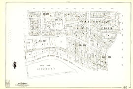
Sheet 77 : Kerr Street to Greenall Avenue and Southeast Marine Drive to Asquith Avenue
Part of City of Vancouver Archives technical and cartographic drawing collection
Item is a section showing the area from Kerr Street to Greenall Avenue and Southeast Marine Drive to Asquith Avenue. Includes streets, blocks, lots and legal descriptions, and the location of parks.
Vancouver (B.C.). Engineering Services

Sheet 76 : Kerr Street to Mondy Avenue and Asquith Avenue to Forty-ninth Avenue
Part of City of Vancouver Archives technical and cartographic drawing collection
Item is a section showing the area from Kerr Street to Mondy Avenue and Asquith Avenue to Forty-ninth Avenue. Includes streets, blocks, lots and legal descriptions, and the locations of schools, parks and cemeteries.
Vancouver (B.C.). Engineering Services

Sheet 75 : Nanaimo Street to Kerr Street and Bobolink Avenue to Forty-ninth Avenue
Part of City of Vancouver Archives technical and cartographic drawing collection
Item is a section showing the area from Nanaimo Street to Kerr Street and Bobolink Avenue to Forty-ninth Avenue. Includes streets, blocks, lots and legal descriptions, and the locations of schools, parks and golf courses.
Vancouver (B.C.). Engineering Services

Sheet 74 : Inverness Street to Nanaimo Street and Sixty-first Avenue to Forty-ninth Avenue
Part of City of Vancouver Archives technical and cartographic drawing collection
Item is a section showing the area from Inverness Street to Nanaimo Street and Sixty-first Avenue to Forty-ninth Avenue. Includes streets, blocks, lots and legal descriptions, and the locations of schools and parks.
Vancouver (B.C.). Engineering Services

Sheet 73 : Quebec Street to Inverness Street and Fifty-seventh Avenue to Forty-seventh Avenue
Part of City of Vancouver Archives technical and cartographic drawing collection
Item is a section showing the area from Quebec Street to Inverness Street and Fifty-seventh Avenue to Forty-seventh Avenue. Includes streets, blocks, lots and legal descriptions, and the locations of schools and parks.
Vancouver (B.C.). Engineering Services

Sheet 72 : Oak Street to Quebec Street and Fifty-eighth Avenue to Forty-sixth Avenue
Part of City of Vancouver Archives technical and cartographic drawing collection
Item is a section showing the area from Oak Street to Quebec Street and Fifty-eighth Avenue to Forty-sixth Avenue. Includes streets, blocks, lots and legal descriptions, and the locations of schools and parks.
Vancouver (B.C.). Engineering Services

Sheet 71 : Cypress Street to Oak Street and Fifty-seventh Avenue to Forty-ninth Avenue
Part of City of Vancouver Archives technical and cartographic drawing collection
Item is a section showing the area from Cypress Street to Oak Street and Fifty-seventh Avenue to Forty-ninth Avenue. Includes streets, blocks, lots and legal descriptions.
Vancouver (B.C.). Engineering Services

Sheet 70 : Macdonald Street to Cypress Street and Fifty-seventh Avenue to Forty-ninth Avenue
Part of City of Vancouver Archives technical and cartographic drawing collection
Item is a section showing the area from Macdonald Street to Cypress Street and Fifty-seventh Avenue to Forty-ninth Avenue. Includes streets, blocks, lots and legal descriptions, and the locations of golf courses, parks and railways.
Vancouver (B.C.). Engineering Services

Sheet 7 : Burrard Street to Main Street and Georgia Viaduct to Burrard Inlet
Part of City of Vancouver Archives technical and cartographic drawing collection
Item is a section showing the area from Burrard Street to Main Street and Georgia Viaduct to Burrard Inlet. Includes streets, blocks, lots and legal descriptions, and the locations of parks, beaches, schools, theatres, post office and Canadian Pacific Railway yards and piers.
Vancouver (B.C.). Engineering Services

Part of City of Vancouver Archives technical and cartographic drawing collection
Item is a section showing the area from Musqueam Indian Reserve to Macdonald Street and North Arm of the Fraser River to Forty-ninth Avenue. Includes streets, blocks, lots and legal descriptions, and golf courses.
Vancouver (B.C.). Engineering Services

Part of City of Vancouver Archives technical and cartographic drawing collection
Item is a section showing the area from Musqueam Indian Reserve to Musqueam Park and North Arm, Fraser River to Southwest Marine Drive. Includes streets, blocks, lots and legal descriptions, and parks.
Vancouver (B.C.). Engineering Services

Sheet 66 : Musqueam Indian Reserve to Balaclava Street and Forty-ninth Avenue to Forty-first Avenue
Part of City of Vancouver Archives technical and cartographic drawing collection
Item is a section showing the area from Musqueam Indian Reserve to Balaclava Street and Forty-ninth Avenue to Forty-first Avenue. Includes streets, blocks, lots and legal descriptions, and the locations of schools, parks and golf courses.
Vancouver (B.C.). Engineering Services

Sheet 65 : Camosun Street to Carnarvon Street and Forty-first Avenue to Thirty-third Avenue
Part of City of Vancouver Archives technical and cartographic drawing collection
Item is a section showing the area from Camosun Street to Carnarvon Street and Forty-first Avenue to Thirty-third Avenue. Includes streets, blocks, lots and legal descriptions, and schools.
Vancouver (B.C.). Engineering Services
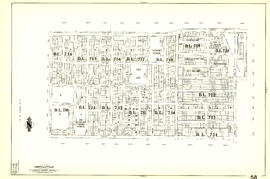
Sheet 64 : Balaclava Street to Cypress Street and Forty-ninth Avenue to Forty-first Avenue
Part of City of Vancouver Archives technical and cartographic drawing collection
Item is a section showing the area from Balaclava Street to Cypress Street and Forty-ninth Avenue to Forty-first Avenue. Includes streets, blocks, lots and legal descriptions, and the locations of parks and schools.
Vancouver (B.C.). Engineering Services

Sheet 63 : Carnarvon Street to Cypress Street and Forty-first Avenue to Thirty-third Avenue
Part of City of Vancouver Archives technical and cartographic drawing collection
Item is a section showing the area from Carnarvon Street to Cypress Street and Forty-first Avenue to Thirty-third Avenue. Includes streets, blocks, lots and legal descriptions, and the locations of parks and schools.
Vancouver (B.C.). Engineering Services

Sheet 62 : Cypress Street to Oak Street and Forty-ninth Avenue to Forty-first Avenue
Part of City of Vancouver Archives technical and cartographic drawing collection
Item is a section showing the area from Cypress Street to Oak Street and Forty-ninth Avenue to Forty-first Avenue. Includes streets, blocks, lots and legal descriptions, and the locations of parks and schools.
Vancouver (B.C.). Engineering Services

Sheet 61 : Cypress Street to Oak Street and Forty-first Avenue to Thirty-third Avenue
Part of City of Vancouver Archives technical and cartographic drawing collection
Item is a section showing the area from Cypress Street to Oak Street and Forty-first Avenue to Thirty-third Avenue. Includes streets, blocks, lots and legal descriptions.
Vancouver (B.C.). Engineering Services
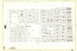
Sheet 60 : Oak Street to Quebec Street and Forty-sixth Avenue to Thirty-seventh Avenue
Part of City of Vancouver Archives technical and cartographic drawing collection
Item is a section showing the area from Oak Street to Quebec Street and Forty-sixth Avenue to Thirty-seventh Avenue. Includes streets, blocks, lots and legal descriptions, and the locations of parks and schools.
Vancouver (B.C.). Engineering Services

Sheet 6 : Nicola Street to Beatty Street and English Bay Beach to Georgia Street
Part of City of Vancouver Archives technical and cartographic drawing collection
Item is a section showing the area from Nicola Street to Beatty Street and English Bay Beach to Georgia Street. Includes streets, blocks, lots and legal descriptions, and the locations of parks, beaches, schools, hospitals and court house.
Vancouver (B.C.). Engineering Services

Sheet 59 : Quebec Street to Inverness Street and Forty-seventh Avenue to Thirty-seventh Avenue
Part of City of Vancouver Archives technical and cartographic drawing collection
Item is a section showing the area from Quebec Street to Inverness Street and Forty-seventh Avenue to Thirty-seventh Avenue. Includes streets, blocks, lots and legal descriptions, and the locations of parks, schools and Mountainview Cemetery.
Vancouver (B.C.). Engineering Services
Sheet 58 : Inverness Street to Nanaimo Street and Forty-ninth Avenue to Forty-first Avenue
Part of City of Vancouver Archives technical and cartographic drawing collection
Item is a section showing the area from Inverness Street to Nanaimo Street and Forty-ninth Avenue to Forty-first Avenue. Includes streets, blocks, lots and legal descriptions, and the locations of parks and schools.
Vancouver (B.C.). Engineering Services

Part of City of Vancouver Archives technical and cartographic drawing collection
Item is a section showing the area from Nanaimo Street to Doman Street and Joyce Street and Forty-ninth Avenue to Forty-first Avenue. Includes streets, blocks, lots and legal descriptions, and the locations of parks and schools.
Vancouver (B.C.). Engineering Services

Sheet 56 : Doman Street and Joyce Street to Boundary Road and Forty-ninth Avenue to Kingsway
Part of City of Vancouver Archives technical and cartographic drawing collection
Item is a section showing the area from Doman Street and Joyce Street to Boundary Road and Forty-ninth Avenue to Kingsway. Includes streets, blocks, lots and legal descriptions. Also included is Central Park and B.C. Electric Railway tracks in Burnaby.
Vancouver (B.C.). Engineering Services

Part of City of Vancouver Archives technical and cartographic drawing collection
Item is a section showing the area from Cecil Street and McHardy Street to Boundary Road and Kingsway to Monmouth Avenue and Price Street. Includes streets, blocks, lots and legal descriptions, and B.C. Electric Railway line. Also included are streets, blocks and B.C. Electric Railway line in the area from Boundary Road to Patterson Avenue in Burnaby.
Vancouver (B.C.). Engineering Services

Part of City of Vancouver Archives technical and cartographic drawing collection
Item is a section showing the area from Nanaimo Street to Joyce Street, Cecil Street and McHardy Street and Forty-first Avenue to Ward Street and Vanness Avenue. Includes streets, blocks, lots and legal descriptions, and the locations of parks and schools.
Vancouver (B.C.). Engineering Services