![[S.S. "Cheam" on Howe Sound Excursion Service]](/uploads/r/null/d/6/0/d60293b7d80a86f11c8e8deff4116df64f95ed9a851a4620394c175d1da8afe3/15cefeeb-b8d9-45c9-93ad-fd73344823ea-CVA374-138_142.jpg)
[S.S. "Cheam" on Howe Sound Excursion Service]
- AM75-S1-: CVA 374-138
- Item
- [ca. 1921]
77 results with digital objects Show results with digital objects
[S.S. "Cheam" on Howe Sound Excursion Service]
![Board of Trade Excursion on the P.G.E. [Pacific Great Eastern]](/uploads/r/null/2/5/3/253028f0a7e19caad09c12892abc302244da74b1727bbe629f8a06f25aab06e1/423124a8-95b4-465b-906c-b251c0063524-CVA374-186_142.jpg)
Board of Trade Excursion on the P.G.E. [Pacific Great Eastern]
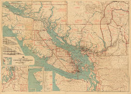
Part contains a commercial and visitors map of the southwestern land districts of British Columbia, encompassing Vancouver Island and the mainland from Seymour Inlet in the northwest to Black Pines in the northeast, extending south to Chiwaukum, Washington. Primary map shows settlements, government agent offices, mining and sub-mining recording offices, game reserves, customs posts, hospitals, ferries, campsites, golf courses, canneries, commercial air harbours, lighthouses, radio stations, motor boat refill stations, power sites, railways, roadways, trails, telegraph and telephone lines, steamship routes, topographic contour lines, and locations of falls and rapids. Text on the map provides information on land features and the presence of wild and farmed animals, and indicates current and possbile agricultural and industrial land use. Inset maps show the northern tip of Vancouver Island, Triangle Island and West and East Haycock Islands, and northwestern Washington State from Seattle to Centralia. A key map shows the location of the area covered by the main map in relation to the rest of North America.
![["Lady Cecilia" approaching float to pick up passengers]](/uploads/r/null/a/c/7/ac7847341267b5c11aea30c48e56bd6b7e9079d5be9857dbd47b164f1b3285e0/27d527d3-bfff-41c4-b20d-58cad637ea50-CVA374-174_142.jpg)
["Lady Cecilia" approaching float to pick up passengers]
![[Upper passenger deck of either "Lady Cecilia" or "Lady Cynthia"]](/uploads/r/null/6/1/9/6196afdfb81937783e4b2caf72226df6616f2e1bf93bb8ed0462b87a37014750/7f89ce80-349d-416a-a8cd-cec4117488e0-CVA374-171_142.jpg)
[Upper passenger deck of either "Lady Cecilia" or "Lady Cynthia"]
![[View of unidentified resort area of Union Estates]](/uploads/r/null/2/e/0/2e03d30a9532a7b59f9a1bda0974b8db763508548579941882dfdb890041945c/79411a1f-303e-4bdb-af29-0eba3f6b9c08-CVA374-481_142.jpg)
[View of unidentified resort area of Union Estates]

Preliminary map : Stikine River
Item is a map of the Stikine River region from Dease Lake in the north to Stewart in the south. Map shows land and timber surveys, government and First Nations reserves, mining division and international boundaries, government agents' offices, mining and sub-mining recording offices, post offices, villages, Hudson's Bay Company posts, telegraph lines, hospitals, schools, radio stations, triangulation stations, railways, roadways, bridges, falls and rapids, glaciers, and topographic contours.
![[Aboard M.V. "Chilco"]](/uploads/r/null/1/2/b/12bb4b0d9b0fb2176cda033ee131ba6fbe76c6c3efc323ceb53cf0cde624d15d/3105ffe8-778c-44da-8341-3c389b50439d-CVA374-255_142.jpg)
Photograph shows William Gardiner, Chief Steward
![[S.S. "Venture" (possibly in Rivers Inlet)]](/uploads/r/null/7/c/c/7cc1ceb6787d5f33bf536a58283853249a7cee122012e48727bad6c8eeca559f/2faebb8d-bbf1-4729-ac9b-515e17ea37d7-CVA374-136_142.jpg)
[S.S. "Venture" (possibly in Rivers Inlet)]
![[Steamer "Capilano" (II) leaving Island Dock]](/uploads/r/null/d/1/d/d1d07abcb13b03d7727b8fd0ec6b91acd72ef0b1cc53cb9be31c217a48694a14/4d6f2231-8701-460c-a716-5f2fccec1feb-CVA374-7_142.jpg)
[Steamer "Capilano" (II) leaving Island Dock]
Item contains a commercial and visitors map of the southwestern land districts of British Columbia on one side and textual information on the region on the other.
![["Lady Cecilia" showing upper passenger deck]](/uploads/r/null/0/2/2/022aa073bd5e77e5c899d73b492ceb53df303453102bf5369516e083fa084d99/e3a2736b-2027-46be-a378-98b1ee2210da-CVA374-170_142.jpg)
["Lady Cecilia" showing upper passenger deck]
![[Aboard] M.V. "Chilco"](/uploads/r/null/b/4/1/b41ffea81be40017ebbf0630b97995cf7f8b571be855e1ec641086b3ffc2736e/2060336d-6a5f-462d-8f00-934c99ee837f-CVA374-253_142.jpg)
Photograph shows Jack Storey (Purser) and Fred Smith (Engineer)
![[Aboard] M.V. "Chilco"](/uploads/r/null/f/c/6/fc6361dd879ee0a5f683283d98f29fb2f9d033431f8900f5d1b10cc8f44a3109/450cf325-3e5a-4c29-93e2-87d8957ca0de-CVA374-254_142.jpg)
Photograph shows - Jack Storey (Purser) and Capt. Frank Powers
![[Aboard] M.V. "Chilco"](/uploads/r/null/8/e/8/8e8bd812b877ffcdfe9a2968efe91f6e8455c2e36e7304550c4c82ed22b39aef/a5b724f6-d2d5-4224-bb46-9c3e8b27099c-CVA374-256_142.jpg)
Photograph shows - Captain Gray and Bill Filtness (Passenger)
![[S.S. "Cheam" at Resort Dock]](/uploads/r/null/5/7/b/57b1d60e98ee3eabbddd2201de8cf098398c8872ea64edae9e0733d673053847/848e8ccf-6fb2-4da0-9ad6-574f050119ba-CVA374-28_142.jpg)
![[Steamer "Capilano" (II) - Port side view]](/uploads/r/null/2/2/8/22829c134e25cef621ec3100e8132514874c97508ba5f7a3e14313e19a887e4a/2e3d5137-f3a3-4c16-b517-1c89dfa5a5dc-CVA374-9_142.jpg)
[Steamer "Capilano" (II) - Port side view]
![[Upper passenger deck of either "Lady Cecilia" or "Lady Cynthia"]](/uploads/r/null/e/f/f/eff451704ce3f3d32c6ae737276a477b46a6c1cb056ccffffad371c9c59c3236/a568a088-e334-4d3f-9638-296719cd11bd-CVA374-172_142.jpg)
[Upper passenger deck of either "Lady Cecilia" or "Lady Cynthia"]

Southwestern districts : Map no. 1K : comparative geographical study
Part contains information on the southwestern districts of British Columbia, including population, climate, agriculture, industry, labour, and education; itineraries for exploring the various regions; information on Canadian customs regulations and game regulations; and diagrams of road routes to British Columbia from California and Alberta/western Washington.

Map no. 2 shewing Union Steamship Company route and ports of call : northern run
Item is a map showing ports of call along Haida Gwaii (Queen Charlotte Islands) and the northern coast of British Columbia from Stewart to Smith Sound.

Map no. 1 shewing Union Steamship Company route and ports of call : lower run
Item is a map showing ports of call along Vancouver Island and the southern coast of British Columbia from Smith Sound to Vancouver.
![[Canadian National Railways Ship] S.S. "Prince Charles" [later Union Ship "Camosun...](/uploads/r/null/9/c/b/9cbff7d1c73194109dca0eca823f00877a22e55f0256787e38616b2e90f5ad9e/7bc36942-59c8-4158-b175-87502a7d8483-CVA374-2_142.jpg)
[Canadian National Railways Ship] S.S. "Prince Charles" [later Union Ship "Camosun" (II)]
![[Floating village from a ship]](/uploads/r/null/b/d/d/bdd8b871ae47efbd8809e7d515330aa97593f31f39bf76bb48bffd6fd23a6cb8/70281e6e-4000-413e-96fb-96e82f0679f0-CVA374-244_142.jpg)
[Floating village from a ship]
![[Floating village]](/uploads/r/null/3/4/6/346db92a826881787c29170756174220783e5796c1b2ed6ea90b9cfb7c31bbe6/d1cc1aac-5757-49f6-ba2d-427bc7d7a162-CVA374-245_142.jpg)

Building a Davis Raft at Cumshewa Inlet
![Sedgewick [Sedgwick] Bay on Queen Charlottes [Haida Gwaii]](/uploads/r/null/5/3/2/53229f0668a0c0f8bb783d31ed1c5794cd6f7aa3c60d326ff43663954069ddc1/c7cd5a11-9eac-4a54-a66e-b9d649fa085c-CVA374-243_142.jpg)
Sedgewick [Sedgwick] Bay on Queen Charlottes [Haida Gwaii]
Photograph shows buildings on floats
![[Life] Boat drill on T.S.S. "Catala"](/uploads/r/null/1/e/e/1ee9c58a2caf2a6d3e821fccea7244b4df2eafa5392c023620d9fe15e3e0b891/13fe9f9b-1c5d-4185-8b71-c88b2ccba6e4-CVA374-167_142.jpg)
[Life] Boat drill on T.S.S. "Catala"
![[S.S. "Catala"]](/uploads/r/null/e/0/8/e0899a4926c2c1bbbb673a97636414caddb85881ad685b762b0ef3606ab102aa/0bec7baa-b3cd-4246-aaee-59a26e52a2bd-CVA374-24_142.jpg)
![[S.S. "Lady Alexandra"]](/uploads/r/null/7/4/e/74e87d22579d72c80b76610fb6a3083e0a77f35f8abf9edcf8901caa3937305e/0a29283e-c0ae-465f-b3c8-bc4c0e86379a-CVA374-95_142.jpg)
Oblique view


![[View of] Portland Canal, B.C. [from aboard a ship]](/uploads/r/null/7/c/b/7cb9a03a807eac9f15c01627c267838d6417bc9dd5b5259d209d87212c3c0e61/40969840-20e1-419f-a176-eb4ece7b7e28-CVA374-232_142.jpg)
[View of] Portland Canal, B.C. [from aboard a ship]

Cottages of the Union Estates Ltd.
Photograph shows twelve buildings at Sechelt, Selm and Bowen Island
![Indian woman [doing laundry at] Charles Creek, Kingcombe Inlet](/uploads/r/null/5/6/8/56830c914b00af81119e540345fab65ab35c94688b642229c439f67baa57ff12/66384637-9d76-4371-82b0-204843a5dc5a-CVA374-208_142.jpg)
Indian woman [doing laundry at] Charles Creek, Kingcombe Inlet
Photograph shows a dug-out canoe

![[S.S. "Lady Alexandra"]](/uploads/r/null/6/2/9/629c61730ba93aebf4e46ce7d9fdd83f7f73f931af3af6cc8c7c545b559b05d4/39a64a9f-c6fa-4d04-a1b3-95333b270700-CVA374-93_142.jpg)
Oblique view
![[View across Kwatna Inlet off Burke Channel through a porthole of S.S. "Cardena"]](/uploads/r/null/0/6/e/06e3019f98bc530acf0339fd8305b91e86b7c28c1612abc73d2b13f99bbcdbff/c3628123-2448-459b-a69b-f2f26c60a081-CVA374-214_142.jpg)
[View across Kwatna Inlet off Burke Channel through a porthole of S.S. "Cardena"]


Repairing fish nets - Margaret Bay
![[Passengers disembarking from S.S. "Lady Cecilia" at unidentified dock]](/uploads/r/null/8/3/6/83636d40bacdb0a86e3d82b967f172086e6f4197d8744cd1830ab0e952960dc5/f620c008-a504-4f1c-ab4c-ea78f916b7fd-CVA374-102_142.jpg)
[Passengers disembarking from S.S. "Lady Cecilia" at unidentified dock]
![[Interior of wheel house on S.S. "Catala"]](/uploads/r/null/3/8/1/381e23111d52d0cb905cc02cce1414cbe2a1030d01db4a2f7441498ded909908/37678dab-2c6a-4e4d-aa54-42e88e71a8e5-CVA374-168_142.jpg)
[Interior of wheel house on S.S. "Catala"]

Raising the Victory Loan Pennant on S.S. "Cardena"
Photograph shows (L to R): T. McIlrath; Jack Lay; C. Arthur, Chief Engineer; Capt. Jack Borden (Master of "Cardena") and Miss Grace Young

Ship's engineers S.S. "Capilano" - R.Whitelaw 2nd Engineer and George Marr, 3rd Engineer
![[S.S. "Chilliwack" (II) at dock]](/uploads/r/null/2/6/f/26fbbe63d9ef32214d1a82f62eb3f47a4d3512f37f01fe1c6f5c586d8a7cbc22/fd5f1a0a-3397-4c7e-ad66-9d3e6b66080c-CVA374-56_142.jpg)
[S.S. "Chilliwack" (II) at dock]
Union Steamships Ltd. - aerial views - B.C. coast ports of call
Album contains professionally taken oblique-perspective photographs of the following ports-of-call along the B.C. coast: Alert Bay, Bowen Island, Bella Bella, Blind Channel, Blubber Bay, Bold Point - Quadra Island, Boswell Inlet, Britannia Beach, Brunswick Cannery, Butedale, Cape Caution, Campbell River, Carlisle Cannery, Church House, Claxton Cannery, Digby Island, Fairview Point - Kaien Island, Gibsons Landing, Granite Bay - Quadra Island, Granthams Landing, Halfmoon Bay, Heriot Bay - Quadra Island, Hidden Inlet Cannery, Hopkins Landing, Jap Inlet (later Hunt's Inlet) - Portier Island, Irvines Landing, Long Bay, Lund, Margaret Bay, New Brighton, Oceanic, Pitt Island, Porteau, Port Alexander, Port Belmont, Port Chester, Port Edward, Port Essington, Port Graves - Gambier Island, Port Irving, Port Neville, Port Simpson, Port Walter, Powell River, Prince Rupert, Roberts Creek, Quathiaski Cove, Redonda Bay, Rivers Inlet, Savary Island, Sechelt, Selma Park, Squamish, Squirrel Cove, Stillwater, Sunnyside Cannery, Swanson Bay, Tamagast Harbour, Topaz Harbour, Vananda, Wadhams, Woodfibre; and Alaska: Ketchikan, Metlakalta, Petersburg, Wrangell. Includes views of canneries, mining towns, Native villages, sawmills, pulp and paper mills, etc.

Item is a copy of a British Columbia Department of Lands map of British Columbia north of the 55th parallel. Map shows cities and towns, smaller settlements, post offices, railways, roadways, trading posts, ferries, hospitals, telegraph lines, government agents' offices, mining and sub-mining recording offices, hatcheries, falls and rapids, drainage flow, and park, provincial, and international boundaries. An inset map shows the far northwest area not shown on the primary map.
![[Howe Sound Ferries Ltd. Dispatcher's Office and Coffee Shop building at unidentified beach]](/uploads/r/null/0/d/1/0d1cc96cd976634087da4cedf8dcf4fce664751681e91f73b61b02fde6e094cb/7d85fce0-0a3d-47a0-be76-528890f58e0a-CVA374-362_142.jpg)
[Howe Sound Ferries Ltd. Dispatcher's Office and Coffee Shop building at unidentified beach]

[Howe Sound Ferries Ltd. ferries: "Chilco", "Bowen", "Chasina" and "Island Flyer" at dock]