
View of house under construction from Killarney Manor at 2890 Point Grey Road
- COV-S62-4---: CVA 296-166
- Item
- 1994
Part of City of Vancouver fonds
10376 results with digital objects Show results with digital objects
View of house under construction from Killarney Manor at 2890 Point Grey Road
Part of City of Vancouver fonds

View of house under construction from inside apartment at Killarney Manor at 2890 Point Grey Road
Part of City of Vancouver fonds
![[View of house and yard at 4573 West 13th Avenue]](/uploads/r/null/a/b/ab530a110ef1e0a3cc17e8e4f1357354835bc1a90f0fbefdc9e2cc68b60d4938/3d505dee-3261-49fd-88c5-377ea85a32c1-A07794_142.jpg)
[View of house and yard at 4573 West 13th Avenue]
Part of Major Matthews collection
![[View of Granville Street, looking north from Angus Street]](/uploads/r/null/7/a/7a1737054aa612c021baa18a1c213f921a3fde4a59ebbf1a2d04b50fe16cc3e1/845085b7-c5af-4c0f-87dc-2896df0ccb74-A08301_142.jpg)
[View of Granville Street, looking north from Angus Street]
Part of Major Matthews collection
J.S. Matthews' notes with print or negative in Archives.
![[View of Fitzgerald McCleery's orchard and farm lands - D.L. 315]](/uploads/r/null/7/2/721836cd34c66c561ba28967c3503a468d637ab54195f3f782574da26255ef73/be7b8e06-810d-452c-980a-196fe3504ee4-A24684_142.jpg)
[View of Fitzgerald McCleery's orchard and farm lands - D.L. 315]
Part of Major Matthews collection
![[View of Fitzgerald McCleery's farm buildings - D.L. 315]](/uploads/r/null/6/e/6e5f9c3c168c680a3efe1c39bd6816255228a501c4755035516a4a90f3520e16/a839d990-cc7b-4fe5-a9b7-d3bc8b6a4d26-A24683_142.jpg)
[View of Fitzgerald McCleery's farm buildings - D.L. 315]
Part of Major Matthews collection
![[View of Burrard Inlet toward Howe Sound from Point Grey]](/uploads/r/null/d/7/d70841724af53c279a31c140bbc1fce42a0aa6a1d3a9c40cff087f263ccc345d/7095bde6-1c57-4e91-b87a-60bb6b7cd9f3-A64735_142.jpg)
[View of Burrard Inlet toward Howe Sound from Point Grey]
Part of Major Matthews collection
![[View of Burrard Inlet from Point Grey]](/uploads/r/null/e/3/e320d8072b352225b343a6bf036a24dfbe3d1f2d722001dd0b12d0aa899d36bb/bb12fe87-3475-4839-9e59-891393008d05-A64782_142.jpg)
[View of Burrard Inlet from Point Grey]
Part of Major Matthews collection
Panoramic view showing a pier and Stanley Park in background.
![[View of Bob Arnott and Ted Campbell on horseback]](/uploads/r/null/a/f/af50d69e7c209b1759422d39a694b9c6e87cb4089bd410f2184f70847e89420c/6a4285b0-b415-4ad8-b33d-a1f318dd12ac-A59979_142.jpg)
[View of Bob Arnott and Ted Campbell on horseback]
Part of Major Matthews collection
![[View of 41st Avenue, looking west from East Boulevard]](/uploads/r/null/c/7/c7fd3880821ca2c44c301667b7256441ee8267b4995133ba0d66021082f51890/0725d08c-d670-4516-b846-b04995e36984-A08320_142.jpg)
[View of 41st Avenue, looking west from East Boulevard]
Part of Major Matthews collection
Photograph shows interurban line, municipal hall for Point Grey, and various businesses, including the Bank of British North America.
![[View of 2100 block of 48th Avenue, looking east towards Maple Street]](/uploads/r/null/7/6/7601ca1c463ba34136368f381728eb60e4b1654aab784cb1b14057b9c887f9ef/79d2a9c7-d06a-46f6-a405-3975b0e281d5-A08577_142.jpg)
[View of 2100 block of 48th Avenue, looking east towards Maple Street]
Part of Major Matthews collection
Photograph shows houses, a pile of split logs at the side of the road, and King George V High School (Magee High School) in the distance. J.S. Matthews' notes with print or negative in Archives.

View looking north west from the Jericho Clubhouse
Part of Jericho Country Club fonds
![[View looking North of Fitzgerald McCleery's farm - District Lot 315]](/uploads/r/null/e/f/2/ef2ed8b0811118507913e4d976d8ae641c3fbd921cbe3939fc913f6eee0b42e1/62ba7470-1c4b-4284-bdd8-b755b6364802-LP355_142.jpg)
[View looking North of Fitzgerald McCleery's farm - District Lot 315]
Part of Major Matthews collection
Item consists of 3 photographs mounted on board to form a sectional panoramic view of the roof of the Celtic Cannery

View from Killarney Manor at 2890 Point Grey Road
Part of City of Vancouver fonds

View from Killarney Manor at 2890 Point Grey Road
Part of City of Vancouver fonds

View from Killarney Manor at 2890 Point Grey Road
Part of City of Vancouver fonds
![[View across the Point Grey Municipal Hall grounds towards West Boulevard]](/uploads/r/null/7/e/7e5090214bf42d9affc1e583cf9aae3b80f35916897a7631c4b2395e3f46bae0/6fc975be-3b6f-4987-83da-3bc8b0fa4405-A50237_142.jpg)
[View across the Point Grey Municipal Hall grounds towards West Boulevard]
Part of John Davidson fonds
![[View across the Point Grey Municipal Hall grounds towards the rear of the Bowser Block]](/uploads/r/null/5/3/530d1e68c9b45ab1c6bfdb9893ffb9b0b664fc52cba3c1b420b290a29dc797f5/a1d3a91c-6fde-485e-a70c-321804ba547b-A50236_142.jpg)
[View across the Point Grey Municipal Hall grounds towards the rear of the Bowser Block]
Part of John Davidson fonds
![[View across Marine Drive from Spanish Banks Beach]](/uploads/r/null/8/8/88654636b34f3edcea5cda523274dbc8f568d5a81772ba7e0ef9fa902f6b4b39/79c0d22f-eb7d-456f-9af3-7cf6edbb98f1-A23679_142.jpg)
[View across Marine Drive from Spanish Banks Beach]
Part of Major Matthews collection
![[View across Marine Drive from Spanish Banks Beach]](/uploads/r/null/d/d/ddc8c6248c4be2cc0f5add2ebe86a350d8a1517b25218c2aaf9782dc77d074e7/df99ca01-f7fd-4530-bfa5-b3f117d3e0f3-A23680_142.jpg)
[View across Marine Drive from Spanish Banks Beach]
Part of Major Matthews collection
Mr. Greig in automobile
![[View across English Bay towards Stanley Park and the North Shore]](/uploads/r/null/9/b/9b5619b3b5a06c5ddfe76131a29d970f52c2f22b700e8a45ef1fd64a1d492686/1c5626f1-d69f-4ed3-aa16-a8d2a18314d1-A62778_142.jpg)
[View across English Bay towards Stanley Park and the North Shore]
Part of Major Matthews collection
![Vancouver, Can[adian] Rotary Club Guests of Mr. R.D. Rorison, Royal Nurseries Luncheon](/uploads/r/null/6/c/6ce77b4abf639d279f4400dfd0bdcdcf79ac707b2f0c7f5056e975703ea75bc8/b83f13ce-f67f-43aa-91be-c86460dc048a-A25127_142.jpg)
Vancouver, Can[adian] Rotary Club Guests of Mr. R.D. Rorison, Royal Nurseries Luncheon
Part of Major Matthews collection
Mr. R.D. Rorison is identified standing front row centre.

Vancouver, British Columbia : south-westerly portion, formerly Point Grey : major street plan
Part of City of Vancouver Archives technical and cartographic drawing collection
Item is a map which has been removed from a copy of the report "A plan for the City of Vancouver, British Columbia, including Point Grey and South Vancouver and a general plan of the region", commissioned by the Vancouver Town Planning Commission from the planning consultants Harland Bartholomew & Associates.
The map shows existing and proposed additions to the major street plan in part of the city that is the former Municipality of Point Grey. The map also shows present street widths, lines of vehicles and roadway widths versus proposed street widths, lines of vehicles and roadway widths.
Harland Bartholomew and Associates
Vancouver Point Grey : the upset riding
Item outlines the election platform of Hilda Thomas and Paul Sabatino, New Democratic Party candidates for Vancouver - Point Grey.

Vancouver Harbour : Sheet 2 (Point Grey to Second Narrows)
Part of City of Vancouver Archives technical and cartographic drawing collection
item is a nautical chart of Burrard Inlet and Vancouver Harbour from Point Grey in the west to Second Narrows in the east, showing soundings in fathoms, tidal information, anchorages, beacons, and waterfront businesses. Street names are shown on land areas. A Royal Canadian Air Force bombing range at Jericho Beach is identified as a danger area.

University of British Columbia
Item is a postcard printed with an image of the University of British Columbia Campus. Caption on back of postcard: "University of British Columbia Campus on the tip of Point Grey with Vancouver's outer harbour and West Vancouver in the background."
University Endowment Lands, District Lot 140, group 1, New Westminster District
Part of City of Vancouver Archives technical and cartographic drawing collection
Item is a map showing proposed land subdivision of the University Endowment Lands and includes a zoning legend. The university buildings and surrounding streets are also included. Notes at the top of the map read, " the design of the subdivision, except with respect to the portion actually subdivided, is tentative" and "the contour elevations are on the City of Vancouver datum which is approximately 100 feet below high water."

University Buildings Point Grey
Part of Major Matthews collection
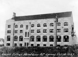
Union College Point Grey, B.C. Opened
Part of Major Matthews collection
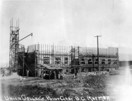
Construction progress photograph at the University of British Columbia

Union College Point Grey, B.C. 1st Floor Slab
Part of Major Matthews collection
Construction progress photograph at the University of British Columbia

Union College Point Grey, B.C.
Part of Major Matthews collection
Construction progress photograph at the University of British Columbia

Union College Point Grey, B.C.
Part of Major Matthews collection
Construction progress photograph at the University of British Columbia
Union College Point Grey, B.C.
Part of Major Matthews collection
Construction progress photograph at the University of British Columbia

Union College Point Grey, B.C.
Part of Major Matthews collection
Construction progress photograph at the University of British Columbia

Union College Point Grey, B.C.
Part of Major Matthews collection
Construction progress photograph at the University of British Columbia

Union College Point Grey, B.C.
Part of Major Matthews collection
Construction progress photograph at the University of British Columbia

Union College Point Grey, B.C.
Part of Major Matthews collection
Construction progress photograph at the University of British Columbia

Union College Point Grey, B.C.
Part of Major Matthews collection
Construction progress photograph at the University of British Columbia

Union College Point Grey, B.C.
Part of Major Matthews collection
Construction progress photograph at the University of British Columbia
![Uganda flag - 2 [9 of 12]](/uploads/r/null/e/0/a/e0a1f4dff5886ce685d12ca132c438f0e0f9a7ec2b62252efc3a130cd9570685/2208e0da-6291-49ef-9d55-071a0dd8e91e-CVA395-07382_142.jpg)
Part of Habitat Forum photographs
![Uganda flag - 2 [8 of 12]](/uploads/r/null/f/9/3/f939bc4f38eaa9fcd8592bc53fa4926060ae5189c9d66b2fc95c4be1ea6a98bf/22549172-ae6f-4052-9ee6-52eda8332eb6-CVA395-07381_142.jpg)
Part of Habitat Forum photographs
![Uganda flag - 2 [7 of 12]](/uploads/r/null/d/8/4/d84a7f856c8314f4962c7c0145002df96096e114287bb14ed497a6430f60cd72/8d8b518e-c233-49ba-963a-4f9851d590ea-CVA395-07380_142.jpg)
Part of Habitat Forum photographs
![Uganda flag - 2 [6 of 12]](/uploads/r/null/8/b/b/8bb021b85be163c3384d8a28d4b7bc893706dd46bd38dcd24621af39b08d50fc/659dd87c-b881-4842-8fe9-627428f2f797-CVA395-07379_142.jpg)
Part of Habitat Forum photographs
![Uganda flag - 2 [5 of 12]](/uploads/r/null/8/4/d/84d8bb7a0012a69f861a23b03c7aabf0bda91203c719656d210b8a74f17f8c74/7a1f1a1e-b7c5-4ab9-9f77-0b37a7874878-CVA395-07378_142.jpg)
Part of Habitat Forum photographs
![Uganda flag - 2 [4 of 12]](/uploads/r/null/d/5/6/d56d9f6f9a6c1b5641399e535e1530761a4a75bc0383a5b3c760a3a3f56b7ffa/59219c01-0e87-4fe4-aa6d-c6426ea38a2f-CVA395-07377_142.jpg)
Part of Habitat Forum photographs
![Uganda flag - 2 [3 of 12]](/uploads/r/null/2/2/3/223ee6c51de3d425ea34cd4e541c06a9efafe735150607a9b9386440984d286d/e10db337-e13d-4d6e-813e-8941e08b4896-CVA395-07376_142.jpg)
Part of Habitat Forum photographs
![Uganda flag - 2 [2 of 12]](/uploads/r/null/a/9/d/a9da1e4b107316aeb34cc245b003f1a2012e2e666f6f1710c490608e669b6c36/17cf3e7e-784e-47f1-b3b4-8a3beed88ec3-CVA395-07375_142.jpg)
Part of Habitat Forum photographs
![Uganda flag - 2 [12 of 12]](/uploads/r/null/b/0/0/b006259ae5ba73f318520cf49ec49d93abe1005394a9f66bb70bf5e4a4935573/b6f74421-83a0-44dc-bed3-f36c2bbe4b85-CVA395-07385_142.jpg)
Part of Habitat Forum photographs
![Uganda flag - 2 [11 of 12]](/uploads/r/null/5/0/7/507679f711a1ae1622f9078c6265821ad46690585c2c1e9321610b4a189f0390/e189206f-989f-4b39-a343-0fe2a94b72e7-CVA395-07384_142.jpg)
Part of Habitat Forum photographs
![Uganda flag - 2 [10 of 12]](/uploads/r/null/d/4/c/d4cb94566749fe7f92cdd46a9fda47822e77e3cbf6b58c0dc073041203f78a58/bdbaaf3f-7c1e-4d5a-998b-d423585008b9-CVA395-07383_142.jpg)
Part of Habitat Forum photographs