
- AM1594-: MAP 385-: 1972-585.2
- Part
- 1890
Part of City of Vancouver Archives technical and cartographic drawing collection
Part is the inner sheet of an unfolded brochure, showing lots offered for sale in the northern portion of District Lot 540.
246 results with digital objects Show results with digital objects
Part of City of Vancouver Archives technical and cartographic drawing collection
Part is the inner sheet of an unfolded brochure, showing lots offered for sale in the northern portion of District Lot 540.

Part of City of Vancouver Archives technical and cartographic drawing collection
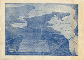
Part is a map showing types of land use in Greater Vancouver, with a chart showing area of specified uses: open and undeveloped, residential, industrial, agricultural, commercial, institutional, transportation, communication and utilities, recreation, and
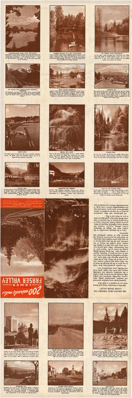
200 miracle miles through the Lower Fraser Valley
Part of City of Vancouver Archives technical and cartographic drawing collection
Part is one side of an unfolded tourism promotion brochure. The various panels depict photographs and give basic information on various sites mapped on the verso of the sheet.
British Columbia. Travel Bureau

A few facts about the north Fraser River
Part of City of Vancouver Archives technical and cartographic drawing collection
Part is a sheet of promtional-type information regarding economic activity in the municpalities bordering the north arm of the Fraser River. It lists nineteen companies operating along the north arm, with information on their capitalisation, turnover, profits, number of employees, etc.

Part of City of Vancouver Archives technical and cartographic drawing collection
Part is the front page of a fold-out brochure advertising Spencer's Department Store, Spencer's furs, and David Spencer Ltd. The page includes an oblique aerial map of the Lower Mainland, and a road map of routes into Greater Vancouver from the south and

Part of City of Vancouver Archives technical and cartographic drawing collection
Part is a sheet with two maps. The main map shows major roads in the Lower Mainland, with Spencer's Department Store illustrated, and points of interest noted. The inset map shows major roads and points of interest in Victoria.

A sketch design for a nonconformist church
Part of City of Vancouver Archives technical and cartographic drawing collection
Part contains front and side elevations for a church building.

A souvenir and correct map of the location of all the fair buildings of the Vancouver Exhibition
Part of City of Vancouver Archives technical and cartographic drawing collection
Part contains text promoting the Western Canada Fair, Vancouver, and British Columbia.

A student to-day, a citizen tomorrow
Part of City of Vancouver Archives technical and cartographic drawing collection
Part contains textual information on Vancouver's growth and future planning initiatives.

Advertisements for Vancouver real estate
Part of City of Vancouver Archives technical and cartographic drawing collection
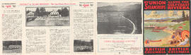
Along the gulf coast riviera by Union Steamships
Part of City of Vancouver Archives technical and cartographic drawing collection
Part is the outer/front side of an unfolded brochure for Union Steamships Limited. The sheet described various tourist destinations along the southern coast that could be reached by Union Steamships services, with information on sights, fares, etc. The sheet also includes photographs of recreation areas around Sechelt.
Union Steamships (Vancouver, B.C.)

Part of City of Vancouver Archives technical and cartographic drawing collection
Part contains general information about British Columbia's government, economy, and resources, and text advertising the services of Western Development and Power Limited.

Automobile road map of Greater Vancouver and environs : inside map cover
Part of City of Vancouver Archives technical and cartographic drawing collection

Automobile road map of Greater Vancouver and environs : map cover
Part of City of Vancouver Archives technical and cartographic drawing collection
Map cover includes advertisements for Eng Chow Company and Happyland.
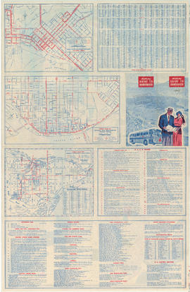
B.C. Electric guide to Greater Vancouver
Part of City of Vancouver Archives technical and cartographic drawing collection
Part is the front side of a folded brochure containing information on the BC Electric transit system in Vancouver. This side includes route maps of services in Downtown Vancouver, central New Westminster, and Richmond. This side also includes a street ind
B.C. Electric guide to Greater Vancouver
Part of City of Vancouver Archives technical and cartographic drawing collection
Part is the front side of a folded brochure containing information on the BC Electric transit system in Vancouver. This side includes route maps of services in Downtown Vancouver, central New Westminster, and Richmond. This side also includes a street index
B.C. Electric guide to Greater Vancouver
Part of City of Vancouver Archives technical and cartographic drawing collection
Part is the front side of a folded brochure containing information on the BC Electric transit system in Vancouver. This side includes route maps of services in Downtown Vancouver, central New Westminster, and Richmond. This side also includes a street ind

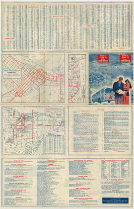
Part of City of Vancouver Archives technical and cartographic drawing collection
Part contains maps of the Richmond and downtown Vancouver transit systems, a street index to the Greater Vancouver map on the other side of the sheet, information on B.C. Electric transit routes, and general tourist information.

B.C. Electric Rly. Co. Ltd. plan showing transit services in Vancouver city as at end of 1951
Part of City of Vancouver Archives technical and cartographic drawing collection
Part is a map showing existing and proposed transit lines in Vancouver.
Part of City of Vancouver Archives technical and cartographic drawing collection
Part contains B.C. Electric logo and J.S. Matthews's annotations regarding the plan.

Part of City of Vancouver Archives technical and cartographic drawing collection
Part is the front sheet of the unfolded pamphlet includes text on attractions, as well as photographs of the park, petting zoo, monuments, trails and gardens, and Malkin Bowl.
Part of City of Vancouver Archives technical and cartographic drawing collection
Item is a sheet with a photograph of the federal Parliament buildings in Ottawa, and biographical sketches of Governors General and Prime Ministers of Canada, as well as of present provincial Lieutenants Governor; a list of Governors General and Prime Min
Bird's eye view of Vancouver, B.C.
Part of City of Vancouver Archives technical and cartographic drawing collection
Part contains an illustrated oblique view of Vancouver showing steamship lines, bridges, beaches, major roads, and the location and block numbers of East Vancouver Heights.

Bird's eye view of Vancouver, B.C.
Part of City of Vancouver Archives technical and cartographic drawing collection
Part is an aerial rendering of Vancouver looking westward from a viewpoint east of Hastings Township. The Broadview area is highlighted.

Part of City of Vancouver Archives technical and cartographic drawing collection
Part depicts text and accompanying diagram on "the art of dialing by a common globe", a chart of universal scale, a map of the world using Mercator's projection, a map of the southern half of the Americans, descriptions of the various maps and charts, and the left-hand side of a map of the lunar surface viewable from Earth.
Dunn, Samuel

Part of City of Vancouver Archives technical and cartographic drawing collection
Part depicts the right-hand side of a map of the lunar surface viewable from Earth, a chart of the Analemma, a chart and accompanying text entitled "the vicissitude of seasons explained", a chart and accompanying text on "the art of dialing by a common globe", and a map of the southern portion of Africa and Asia, as well as Australia.
Dunn, Samuel
Part of City of Vancouver Archives technical and cartographic drawing collection
Item is a sheet which includes maps of British Columbia, England, Scotland, Ireland and the world polar region; photographs of Hon. R.L. Borden (Prime Minister of Canada) and S. Richard McBride (Premier of British Columbia), as well as illustrations of Ha
Part of City of Vancouver Archives technical and cartographic drawing collection
Item is a sheet of general and statistical information about British Columbia: lists of principal freshwater and saltwater lakes of the world, and index of British Columbia towns and British Columbia political, demographic and economic information.

Part of City of Vancouver Archives technical and cartographic drawing collection
Part contains a map showing street car, interurban, and motor bus lines in from Vancouver to New Westminster, a map showing existing and projected power plants near Alouette and Stave Lakes, and a profile showing the existing and proposed plants.

British Columbia Electric Railway Company Limited : Vancouver Island system and Mainland system
Part of City of Vancouver Archives technical and cartographic drawing collection
Part contains two maps showing city, suburban, and interurban railway lines, transmission lines, generating stations, substations, and transformers.

Bus routes, city of Vancouver, November 26th 1937
Part of City of Vancouver Archives technical and cartographic drawing collection
Part of City of Vancouver Archives technical and cartographic drawing collection
Item is a sheet with maps of Canada, Newfoundland, and the United States; photographs of the Lieutenant Governors of each province, the Governor General and various Prime Ministers of Canada.
Canadian Pacific agencies around the world
Part of City of Vancouver Archives technical and cartographic drawing collection
Part is the inside cover for the brochure, which lists the locations of Canadian Pacific agencies.
Canadian Rockies showing main line of Canadian Pacific Railway
Part of City of Vancouver Archives technical and cartographic drawing collection

Champlain Heights : D.L. 334, group one, N.W.D.
Part of City of Vancouver Archives technical and cartographic drawing collection
Part is a map showing lot numbers, lot sizes, lot values and sidewalk crossings in the area from Rosemont Drive in the north to 63rd Avenue in the south and from Butler Street in the east to Kerr Street in the west.

Circulation map of Greater Vancouver : today's market data on Vancouver
Part of City of Vancouver Archives technical and cartographic drawing collection
Part contains maps and population and circulation data for three areas: Retail City Area, Retail Suburban Area, and All Other Country Area.
Part of City of Vancouver Archives technical and cartographic drawing collection
Part is the enclosed tourist map of Vancouver, including a street index. Map contains a dial which denotes distance from the Yale Hotel.

City of Vancouver : Canadian Pacific town site
Part of City of Vancouver Archives technical and cartographic drawing collection
Part contains four maps. The main map shows district lots and block numbers in Vancouver from Vine Street in the west to Boundary Avenue (Glen Drive) in the east and Stanley Park in the north to 9th Avenue (Broadway) in the south. Three smaller maps include an index plan to district lots in Vancouver, South Vancouver, New Westminster, and Burnaby; a world map showing Canadian Pacific mail steamship lines; and an index plan of Vancouver city limits. Part has been annotated with text describing a June 1888 land clearance plan and hand colouring indicating clearance status.

City of Vancouver : Canadian Pacific town site
Part of City of Vancouver Archives technical and cartographic drawing collection
Part contains four maps. The main map shows district lots and block numbers in Vancouver from Vine Street in the west to Boundary Avenue (Glen Drive) in the east and Stanley Park in the north to 9th Avenue (Broadway) in the south. Three smaller maps include an index plan to district lots in Vancouver, South Vancouver, New Westminster, and Burnaby; a world map showing Canadian Pacific mail steamship lines; and an index plan of Vancouver city limits.

City of Vancouver : residential lots, Area B, Champlain Heights : page 1
Part of City of Vancouver Archives technical and cartographic drawing collection
Part is the first of two sheets outlining details associated with the sale of lots in Champlain Heights as shown on the map "Champlain Heights : D.L. 334, group one, N.W.D." (LEG1315.1).

City of Vancouver : residential lots, Area B, Champlain Heights : page 2
Part of City of Vancouver Archives technical and cartographic drawing collection
Part is the second of two sheets outlining details associated with the sale of lots in Champlain Heights as shown on the map "Champlain Heights : D.L. 334, group one, N.W.D." (LEG1315.1).
City of Vancouver. Canadian Pacific town site
Part of City of Vancouver Archives technical and cartographic drawing collection
Part is a map sheet with one principal map, three inset maps and one illustration. The main map is a copy of a L.A. Hamilton map of downtown Vancouver and the land surrounding False Creek. Textual information is provided about the history and layout of Stanley Park. Inset maps show the Canadian Pacific mail steamships lines around the world and an index plan of Vancouver, B.C.

City of Vancouver. Canadian Pacific town site
Part of City of Vancouver Archives technical and cartographic drawing collection
Part is a map sheet with one principal map, three inset maps and one illustration. The main map is a copy of a L.A. Hamilton map of downtown Vancouver and the land surrounding False Creek. Textual information is provided about the history and layout of Stanley Park. Inset maps show the Canadian Pacific mail steamships lines around the world and an index plan of Vancouver, B.C. An illustration is incuded of the north shore mountains as seen from Vancouver.

City of Vancouver. Fifth Sale. Lots and blocks in Lot 540
Part of City of Vancouver Archives technical and cartographic drawing collection
Part is the outer sheet of an unfolded brochure advertising the sale of lots owned by the provincial government. The map included in the sheet is an index map of greater Vancouver, showing the location of District Lot 540.
![City of Vancouver surrounding [sic] and municipalities including City of New Westminster](/uploads/r/null/8/9/1/8919931915a624a5abd2e5d2953118fdd853654343ce31193f00d341d482bf39/fd6eb299-3e6a-498e-bfd9-62a3279a8861-LEG1329_142.jpg)
City of Vancouver surrounding [sic] and municipalities including City of New Westminster
Part of City of Vancouver Archives technical and cartographic drawing collection
Part contains a street map showing distances from a point in downtown Vancouver, waterfront businesses in Burrard Inlet, street car lines, bus lines, parks, golf courses, schools and hospitals.

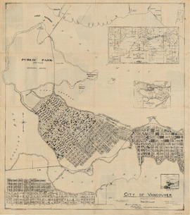
City of Vancouver, British Columbia : zoning diagram
Part of City of Vancouver Archives technical and cartographic drawing collection
Part contains a zoning map showing city streets, residential, apartment, commercial and industrial districts, as well as parkways and open spaces. Concentric circles spaced a mile apart on the map emanate from a point in downtown Vancouver.
Cityscape: A map of downtown Vancouver
Part of City of Vancouver Archives technical and cartographic drawing collection
Part is the recto side of a sheet, containing two maps, as well as lists of restaurants, entertainment venues, hotels, department stores, malls, art galleries, cab companies, and a brief history of Stanley Park. Maps are a street map of downtown and Stanl