- AM1594-: MAP 303
- Item
- [ca. 1915?]
Part of City of Vancouver Archives technical and cartographic drawing collection
Item is a map showing land subdivisions for West Vancouver, streets, and railway routes.
76 results with digital objects Show results with digital objects
Part of City of Vancouver Archives technical and cartographic drawing collection
Item is a map showing land subdivisions for West Vancouver, streets, and railway routes.
West section Richmond municipality
Part of City of Vancouver Archives technical and cartographic drawing collection
Item is a copy of part of a published map of Richmond, B.C. The map shows lot numbers, post offices, dikes, streets, roads, swinging bridges, churches, schools, municipal boundaries and geographical features in the area from Marpole in the north to Gunn Island in the south and from Jacombs Road in the east to Sturgeon Bank in the west. The portion has been annotated with a grid, but information is included which indicates what the lines mean.

Part of City of Vancouver Archives technical and cartographic drawing collection
Item is a map showing New Westminster Land District, including lands alienated or covered by application under the Land Act; surveyed timber leases, licences, or berths; Indian reserves; Government reserves; provincial forest boundaries; tree farm licences; municipality boundaries; and park boundaries. Includes a key plan of maps published in the same publisher's series and a reliability diagram noting data sources.
Vancouver, B.C., Pacific terminus of the C.P.R.
Part of City of Vancouver Archives technical and cartographic drawing collection
Item is a brochure published by a real estate development company, promoting the city and its properties. The front side of the unfolded brochure contains information about the city, about Ross and Ceperley, and has information about prominent buildings, many with photographs or illustrations.
![[Vancouver, B.C. : district lots]](/uploads/r/null/4/a/4a5c15633319c3754d3aa0cc525470bfebcf5a98ad8caeedf44b777194f300bd/2f055d65-47f7-4679-bb91-66b8f1843d2f-MAP531_142.jpg)
[Vancouver, B.C. : district lots]
Part of City of Vancouver Archives technical and cartographic drawing collection
Item is a map of Vancouver showing established District Lots as of 1913, and Government and Indian reserves.

Vancouver North. British Columbia
Part of City of Vancouver Archives technical and cartographic drawing collection
Item is a topographical map showing the eastern portion of Sechelt Peninsula, Keats Island, southern portion of Gambier Island, Bowen Island, West Vancouver, North Vancouver, and Vancouver. City streets and blocks are shown, as well as surveyed parcels of land. Map also shows depth contours in fathoms for Howe Sound and Burrard Inlet.
Vancouver Harbour, British Columbia
Part of City of Vancouver Archives technical and cartographic drawing collection
Item is a nautical chart of Burrard Inlet, including the southern portions of the North Arm of Burrard Inlet. The map shows depth soundings, harbour anchorages, headlines, beacons, buoys, bells, piers and wharves. The map also shows lot numbers, municipal boundaries and major street names of the southern portion of North Vancouver and the northern portions of Point Grey, Kitsilano, Mt. Pleasant, Fairview, Hastings Townsite, Burnaby and Port Moody from the Coquitlam municipal boundary in the east to the western boundary of the Vancouver harbour (between Point Atkinson and Point Grey) in the west. The item also includes a key map showing the location of the Vancouver Harbour in relation to northwestern Washington and Vancouver Island and an inset map showing lots surrounding the north arm of Burrard Inlet to the Inlailawatash Indian Reserve.
Vancouver Harbour : plan of south shore, Burrard Inlet between Heatley Ave. and Victoria Dr.
Part of City of Vancouver Archives technical and cartographic drawing collection
Item is a map which shows parcels of land along Burrard Inlet and district lots in downtown Vancouver. Piers, factories and mills along the waterfront are identified. Soundings are shown in feet.
National Harbours Board

Part of City of Vancouver Archives technical and cartographic drawing collection
Item contains both nautical chart and map data. Nautical chart data includes soundings, anchorages, ferry lines, wharves, and waterfront businesses. Map features include district lots, streets, railways, and municipal boundaries.

Vancouver City : plan of Subdivision of lot 301, Group 1, New Westminster District
Part of City of Vancouver Archives technical and cartographic drawing collection
The map shows the subdivision of lots in the boundary area of Vancouver and South Vancouver, around the current areas of Mount Pleasant and Grandview.

Vancouver and Northern Railway, 1908
Part of City of Vancouver Archives technical and cartographic drawing collection
Item is a portion of a larger topographic map which supposedly has been annotated to show proposed railway routes from North Vancouver, along Howe Sound, to Alta Lake. The annotations have been made on a portion of a topographical map, most likely published by the British Columbia Department of Lands.
Vancouver 1886-1986 : yesterday, gateway to the Pacific : today, crossroads of the world
Part of City of Vancouver Archives technical and cartographic drawing collection
Map is a souvenir poster reproduced from an original in the National Map Collection, Public Archives of Canada. The map shows lot numbers and lot boundaries for the city of Vancouver as of June 1886. The original map was entitled "Plan of the city of Vancouver, Western Terminus of the Canadian Pacific Railway".

Part of City of Vancouver Archives technical and cartographic drawing collection
Item is a map showing land subdivision in the New Westminster District. The map shows lands alienated or covered by applications under the "Land Act"; surveyed timber leases, licences, and births; and Indian reserves; shows land district boundaries; park boundaries; provincial forest boundaries; forest management licences; and municipal boundaries.
The map appears to be based on the National Topographic Series 1:250,000 map 92G, with other data added.

Part of City of Vancouver Archives technical and cartographic drawing collection
Item is a map showing land subdivision in the New Westminster District. The Reference index indicates that lands alienated or covered by applications under the "Land Act"; surveyed timber leases, licences, and births; and Indian reserves are noted; none of these categories of land have been colour-coded on the map. The map also shows land district boundaries; park boundaries; provincial forest boundaries; forest management licences; and municipal boundaries.
The map appears to be based on the National Topographic Series 1:250,000 map 92G, with other data added.
University Endowment Lands, District Lot 140, group 1, New Westminster District
Part of City of Vancouver Archives technical and cartographic drawing collection
Item is a map showing proposed land subdivision of the University Endowment Lands and includes a zoning legend. The university buildings and surrounding streets are also included. Notes at the top of the map read, " the design of the subdivision, except with respect to the portion actually subdivided, is tentative" and "the contour elevations are on the City of Vancouver datum which is approximately 100 feet below high water."

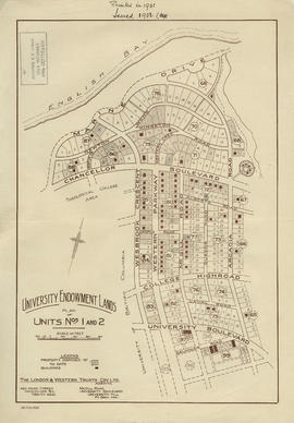
University Endowment Lands : plan of units nos. 1 and 2
Part of City of Vancouver Archives technical and cartographic drawing collection
Item is a map showing streets, land subdivision, properties disposed of, and buildings in the University Endowment Lands north of University Boulevard. Telephone numbers have been changed, issuing date added, and additional blocks filled in by hand, likely by J.S. Matthews.
University Endowment Lands : plan of units nos. 1 and 2
Part of City of Vancouver Archives technical and cartographic drawing collection
Item is a map showing streets, land subdivision, properties disposed of, and buildings in the University Endowment Lands north of University Boulevard. Additional blocks have been filled in by hand, likely by J.S. Matthews.

University Endowment Lands : plan of units no. 1 and 2
Part of City of Vancouver Archives technical and cartographic drawing collection
Item is a map showing streets, land subdivision, properties disposed of, and buildings in the University Endowment Lands north of University Boulevard. Additional blocks have been filled in by hand, likely by J.S. Matthews.
![[Third section of] Shaughnessy Heights](/uploads/r/null/b/9/c/b9c97036cadac8b6ffc53f2380c1c158d767da3473d29ad1b04968cc742d132e/0301116d-9946-489d-a272-9d6453523103-MAP331_142.jpg)
[Third section of] Shaughnessy Heights
Part of City of Vancouver Archives technical and cartographic drawing collection
Item is a map showing lot subdivisions in the portion of Shaughnessy Heights south of Thirty-seventh Avenue as of January 1st, 1931.
The Estate of Joseph Martin, K.C., MP
Part of City of Vancouver Archives technical and cartographic drawing collection
Item is a promotional brochure advertising the sale of lots from the former estate of Joseph Martin, K.C., MP.

Southerly portion. Vancouver Island
Part of City of Vancouver Archives technical and cartographic drawing collection
Item is an economic map which depicts Vancouver Island south of Buttle Lake, as well as coastal areas of the mainland from the approximate location of Britannia Beach, south and the northern coast of the Olympic Peninsula. Information included in the map include Timber Licenses, Indian reserves, other land reserves, municipal boundaries, District Lots outside municipalities, geographic features (not including topography), transportation routes, and parks.
Southerly portion of Vancouver Island
Part of City of Vancouver Archives technical and cartographic drawing collection
Item is a geographic and economic map of the southern half of Vancouver Island. The map shows parcels of land, including Crown land granted, timber leases and licences, Indian reserves, government reserves, and various political boundaries boundaries.
![Sectional map [Kaslo Street to Yale Street to Cotton Drive to East 1st Avenue]](/uploads/r/null/5/b/5b3ce173622ff68f920706abdf2b71af76caf9469cb2cbd3346b37f55694015e/4e7b285b-63cb-45b1-8e0c-6002788dbae6-MAP427_142.jpg)
Sectional map [Kaslo Street to Yale Street to Cotton Drive to East 1st Avenue]
Part of City of Vancouver Archives technical and cartographic drawing collection
Item is a portion of a sheet from the city's sectional plan.
Vancouver (B.C.). Engineer's Office
![[Second section of] Shaughnessy Heights](/uploads/r/null/9/4/d/94d42178bb60a8c60cdc002199430e863ae830696947ad73807b5fd11046c39a/72c651d3-6742-4c5c-a0bc-d83c3526a9ba-MAP330_142.jpg)
[Second section of] Shaughnessy Heights
Part of City of Vancouver Archives technical and cartographic drawing collection
Item is a map showing lot subdivision of the southern portion of Shaughnessy Heights (commonly referred to as "Second Shaughnessy") at January 1st, 1932.
Canadian Pacific Railway Company

Second section : Shaughnessy Heights
Part of City of Vancouver Archives technical and cartographic drawing collection
Item is a map showing lot subdivision of the southern portion of Shaughnessy Heights (commonly referred to as "Second Shaughnessy") at January 1st, 1932. Annotations appear to refer to zoning restrictions.
Canadian Pacific Railway Company
Revised list of remaining 50 lots in subdivision of south half of section 35, Hastings Townsite
Part of City of Vancouver Archives technical and cartographic drawing collection
Item contains maps and information regarding lots for sale in the area bounded by Slocan Street, Renfrew Street, 9th Avenue, and 12th Avenue in Hastings Townsite. Sheets include annotations indicating changes in pricing and lots sold.

Part of City of Vancouver Archives technical and cartographic drawing collection
Item is a map of the southwest coast of British Columbia from Cortes Island to Alta Lake and Chilko Lake to the northern tip of Gabriola Island. Map shows timber leases, Crown granted land, parks, municipalities, power lines, roads, railways, elevation of lakes and some mountains, hospitals, schools and canneries.

Portions of New Westminster District and Vancouver Island
Part of City of Vancouver Archives technical and cartographic drawing collection
Item is an economic map which depicts the area of central Vancouver Island made up of the Comox, Nelson, and Newcastle land divisions, as well as portions of the Alberni, Cameron and Nanoose land district. The map includes the inside passage islands between Lasqueti and Sonora Islands, and the coastal portion of the New Westminster land district from Bute Inlet south to the mouth of the north arm of the Fraser River.
Information included on the map includes timber licenses, Indian reservations, other government reserves, District Lots, physical features (not including topography), and municipal boundaries.

Port Moody, the western terminus of the Canadian Pacific Railway
Part of City of Vancouver Archives technical and cartographic drawing collection
Item is a map showing lots surveys and made available for purchase in Port Moody.

Plan showing lands occupied in Stanley Park near Brockton Point, City of Vancouver, B.C.
Part of City of Vancouver Archives technical and cartographic drawing collection
Map shows parcels of land (1-8) in Stanley Park and indicates what kind of structures are located on the land. The area for each parcel of land is given in acres.
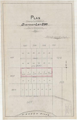
Plan shewing subdivision of District Lot 200. South Vancouver, B.C.
Part of City of Vancouver Archives technical and cartographic drawing collection
Item is a map depicting a planned subdivisions of District Lot 200, located near River Road. Surrounding District Lots are also shown.

Plan of West Vancouver Municipality
Part of City of Vancouver Archives technical and cartographic drawing collection
Item is a map showing land subdivisions in West Vancouver, and annotated by J. S. Matthews with historic names and locations. A small key map shows the location covered by the primary map in relation to the rest of the Lower Mainland.

Part of City of Vancouver Archives technical and cartographic drawing collection
Item is a map depicting lot boundaries and lot dimensions, possibly showing lots for sale.
![Plan of town of Lonsdale : situate [sic] on harbour opposite City of Vancouver](/uploads/r/null/c/5/d/c5d4b56db1d7f9e1cf57dd5a974f6fcb23507e64543bad1bdd8f62139042389f/1cc57eaf-6c92-438e-a65d-335940738df7-MAP686_142.jpg)
Plan of town of Lonsdale : situate [sic] on harbour opposite City of Vancouver
Part of City of Vancouver Archives technical and cartographic drawing collection
Map shows lot numbers and boundaries in the area from Keith Road in the north to Burrard Inlet in the south and from St. Patrick's road in the east to Chesterfield Avenue in the west. Several lots at St. Andrews Road and Fourth Street are hand-coloured pink, but the significance of the colouring is unknown. The ancillary map is an index map showing the location of Lonsdale in relation to Burrard Inlet and Vancouver.

Plan of the townsite of North Vancouver
Part of City of Vancouver Archives technical and cartographic drawing collection
item is a map showing lots and land subdivision in North Vancouver, most likely related to real estate sales. Index map shows the location of North Vancouver relative to Greater Vancouver.

Plan of the town of Newcastle, English Bay
Part of City of Vancouver Archives technical and cartographic drawing collection
Item is a map showing lot numbers and street names for the proposed town of Newcastle on the north shore of English Bay in what is now West Vancouver. An index map shows the location of Newcastle in relation to Vancouver and English Bay.

Plan of the municipality of South Vancouver
Part of City of Vancouver Archives technical and cartographic drawing collection
Item is a map showing streets, lot numbers and lot boundaries in the municipality of South Vancouver.
Plan of the City of Vancouver, British Columbia
Part of City of Vancouver Archives technical and cartographic drawing collection
Item is a map sheet with two maps of Vancouver. The main map shows District Lots, blocks and ranges of lot numbers, streets, railway lines, and boundaries in Vancouver. The inset map shows Stanley Park with rough depictions of topography.

Plan of the City of Vancouver, British Columbia
Part of City of Vancouver Archives technical and cartographic drawing collection
Item is a map showing District Lots, blocks and lots for the City of Vancouver with an inset of an index plan. The sheet also includes an index plan showing the Lower Mainland north of 16th Avenue, and an inset map of Stanley Park.

Plan of the City of Vancouver, British Columbia
Part of City of Vancouver Archives technical and cartographic drawing collection
Item is a partial copy of a map of Vancouver, showing only the western portion of the pre-1929 city.

Plan of the City of Vancouver, B.C.
Part of City of Vancouver Archives technical and cartographic drawing collection
Item is a map which shows city lots and blocks, with street car lines, postal block numbers, and district names shown in red.

Part of City of Vancouver Archives technical and cartographic drawing collection
Item is a reduced size copy of the Hermon & Burwell map Plan of the City of Vancouver. This copy is ca. 1/4 the size of the original map. The map shows District Lots, blocks and lots; transportation infrastructure such as bridges and railway and streetcar lines; and the identification of some industries, especially along the various waterfronts.

Part of City of Vancouver Archives technical and cartographic drawing collection
Item is a subdivision map, showing lot and block numbers for Kitsilano area from English Bay in the north to 1st Avenue in the south and from Chesnut Street in the east to Yew Street in the west.
Garden & Taylor, B.C. Land Surveyors

Plan of subdivision of part of D.L. 526 : South Vancouver
Part of City of Vancouver Archives technical and cartographic drawing collection
Item is a map denoting Canadian Pacific land in D.L. 526. The map shows blocks 581-584, 601-604, 621-624, 661-664, 681-684 bounded on the north by 20th Ave., south by McMullen Ave., east by Ontario Street, and west by Bridge Street.

Part of City of Vancouver Archives technical and cartographic drawing collection
Item is a map showing major streets, lot numbers, lot boundaries and property sold or reserved in the area from Chaldecott Road (now King Edward Ave.) in the north to Magee Road (now W. 49th Ave.) in the south. Kaye Road (now Trafalgar St.), Wilson Road (now W. 41 Ave.), Bodwell Road (now W. 33rd Ave.) and Johnson Road (now Blenheim) are all included on the map.

Plan of subdivision of D in lot 183 and subdivision of J in lot 182, City of Vancouver
Part of City of Vancouver Archives technical and cartographic drawing collection
Item is a subdivision map showing block and lot numbers of subdivisions D and J in lots 183 and 182 respectively. These areas are situated roughly between Burrard Inlet in the north and First Avenue in the south and between Victoria Drive in the east and Clark in the west.
Garden, Hermon and Burwell, Provincial Land Surveyors
![Plan of re-subdivision of lots 3 to 14, subn [subdivision] 2 of bk [block] 3. D.L. 391 & 392](/uploads/r/null/4/a/4a0ea6aa076433c7bcad0c847f7acb3bb1046f7abf2801c48b97d9ca58f49a73/9bd508e4-c85e-4090-b266-27571c5d4dbc-MAP754_142.jpg)
Plan of re-subdivision of lots 3 to 14, subn [subdivision] 2 of bk [block] 3. D.L. 391 & 392
Part of City of Vancouver Archives technical and cartographic drawing collection
Map shows the subdivision of lots in the block bordered by 31st Avenue East, 32nd Avenue East, St. Catherines Street and Windsor Street, at that time in the District of South Vancouver. Map is certified by the surveyor Arthur H. Holland, British Columbia Land Surveyor, and W.A. Pound, Reeve of the District of South Vancouver. It is unclear as to whether the map was commissioned by the Corporation of the District of South Vancouver.
Part of City of Vancouver Archives technical and cartographic drawing collection
Item is an advertisement for real estate in the area bounded by Campbell Street (Alma Street), Richards Street (Balaclava Street), English Bay, and 15th Avenue, with a map of properties on one side and textual advertisements on the other.

Part of City of Vancouver Archives technical and cartographic drawing collection
Item is a map showing lot numbers, lot boundaries and property sold or reserved northwest of Capilano Creek along the north shore of Burrard Inlet. The map does not include street names.

Part of City of Vancouver Archives technical and cartographic drawing collection
Item is a map showing lot numbers, lot boundaries, major streets and property sold or reserved in the area bounded by Campbell Street (Alma Street), present-day Trafalgar Street (unnamed on map), English Bay, and 16th Avenue.