
Wartime Housing cottages in North Vancouver
- COV-S397-: LEG1593.1-: CVA 163-5
- Part
- Jan. 13, 1942
Part of City of Vancouver fonds
25 results with digital objects Show results with digital objects
Wartime Housing cottages in North Vancouver
Part of City of Vancouver fonds

Part of City of Vancouver fonds

Wartime cottage next to permanent home in North Vancouver
Part of City of Vancouver fonds

View from Suspension Bridge, Capilano Canyon, B.C. Canada
Item is a postcard
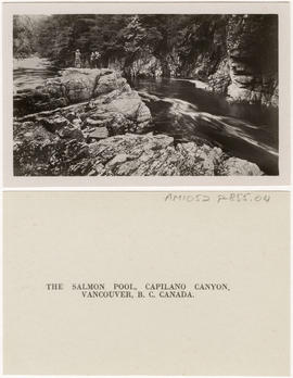
The Salmon Pool, Capilano Canyon, Vancouver, B.C., Canada
Item is a postcard

The Lions and Capilano River, Vancouver, B.C. Canada
Item is a postcard

Suspension Bridge, Height 450 ft, Capilano Canyon, Vancouver, B.C. Canada
Item is a postcard

Suspension Bridge, Capilano Canyon, Vancouver, B.C. Canada
Item is a postcard
![Suspension Bridge, Capilano Canyon, Height 200 ft,, Lentgh [Length] 450 ft, Vancouver, B.C. Canada](/uploads/r/null/5/5/a/55a2c61dc1b86111d8c33c8242c4f1d14cc6a09c4db9ef1e7b0664fbeb991b45/ae7ddc36-6a5f-42f2-9c06-b7a0bfc3fab9-AM1052P-855_142.jpg)
Suspension Bridge, Capilano Canyon, Height 200 ft,, Lentgh [Length] 450 ft, Vancouver, B.C. Canada
Item is a postcard

Suspension Bridge from Look-Out Point, Capilano Canyon, Vancouver, B.C. Canada
Item is a postcard

Street index (Royal Oak Avenue, Vancouver to Frederick Road, North Vancouver)
Part of City of Vancouver Archives technical and cartographic drawing collection
Part contains two pages from the booklet accompanying a guide map of Greater Vancouver. Pages include the last portion of the Vancouver and Burnaby street index, the New Westminster street index, and the North Vancouver street index from 1st Street to Frederick Road.

Street index (Gibson Street to William Street) and tram stations
Part of City of Vancouver Archives technical and cartographic drawing collection
Part is a page from the booklet accompanying a guide map of Greater Vancouver, and contains the last portion of the North Vancouver street index, the West Vancouver street index, and a list of Vancouver tram stations.

Part of City of Vancouver fonds
Part is the southern half of a map of the Capilano River, depciting the area of the Capilano River valley from the river's mouth at Burrard Inlet north to District Lot 596.
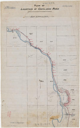
Part of City of Vancouver fonds
Part is the northern half of a map of the Capilano River, depicting the area of the Capilano River valley from District Lots 595 and 602 north to the dam located in District Lot 673.

Map of West Vancouver and vicinity
Part of City of Vancouver Archives technical and cartographic drawing collection
Part contains a map of West Vancouver, North Vancouver, and the northern parts of Vancouver and Burnaby. Map shows district lot and block numbers, streets, and distances from City Hall.

Part of City of Vancouver Archives technical and cartographic drawing collection
Part contains an illustrated map of West Vancouver and North Vancouver showing major streets, mountains, rivers and creeks, and recreational attractions; a street index to the Greater Vancouver map on the other side of the sheet; a list of golf courses; and real estate information including a description of professional realtors, an amortization table, and calculations showing amounts paid in rent over many years.

Part consists of a street map of the Lower Mainland and Fraser Valley from Vancouver to Chilliwack, a street map of New Westminster, a map of Vancouver and North Vancouver showing street names but not street lines, and text advertising the products and services of the Dominion Map and Blueprint Company.
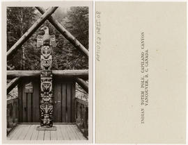
Indian Totem Pole, Capilano Canyon, Vancouver, B.C. Canada
Item is a postcard
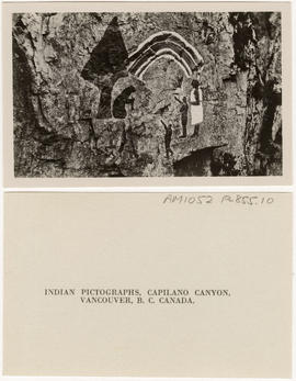
Indian Pictographs, Capilano Canyon, Vancouver, B.C. Canada
Item is a postcard
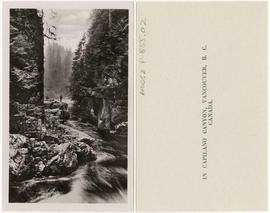
In Capilano Canyon, Vancouver, B.C. Canada
Item is a postcard

Dial map of Greater Vancouver and suburbs
Part of City of Vancouver Archives technical and cartographic drawing collection
Part contains a street map of Vancouver, Burnaby, New Westminster, West Vancouver and North Vancouver showing block numbers, street car, bus, and railway lines, parks and hospitals. Map includes two dials (a numbered circle, a paper indicator, a grid of block numbers and a street index used to find locations). A small inset map shows the Capitol Hill/Scenic Park area of Burnaby in greater detail.

Dial map of Greater Vancouver and suburbs
Part of City of Vancouver Archives technical and cartographic drawing collection
Part contains a street map of Vancouver, Burnaby, New Westminster, West Vancouver and North Vancouver showing block numbers, street car, bus, and railway lines, parks and hospitals. Map includes two dials (a numbered circle, a paper indicator, a grid of block numbers and a street index used to find locations). A small inset map shows the Capitol Hill/Scenic Park area of Burnaby in greater detail.

Dial map of Greater Vancouver and suburbs
Part of City of Vancouver Archives technical and cartographic drawing collection
Part contains a street map of Vancouver, Burnaby, New Westminster, West Vancouver, and North Vancouver showing railways, hospitals, parks and block numbers. The map includes two dials (numbered circles, paper indicators, a grid of block numbers and a street index used to find locations).