![Yukon [Street] and Broadway [traffic controller]](/uploads/r/null/e/1/3/e13fd7ed9ccce01a3203080689faf22ce754646a401ab04d94ff09fe937f464f/8340c892-7049-4806-a9e8-23c1d1e3e8ef-2019-103.0280_142.jpg)
Yukon [Street] and Broadway [traffic controller]
- COV-S505-1-: 2019-103.0280
- Item
- [198-?]
Part of City of Vancouver fonds
6048 results with digital objects Show results with digital objects
Yukon [Street] and Broadway [traffic controller]
Part of City of Vancouver fonds
![Yukon [Street] and Broadway [looking] west](/uploads/r/null/2/0/20ac3837786628c824679fccb02ef227d42bb3bdee38a7ff1ce2852fc673c479/1b529783-c61d-4db5-861c-e7baaab06ef5-A44519_142.jpg)
Yukon [Street] and Broadway [looking] west
Part of City of Vancouver fonds
![Yukon [Street] and Broadway [looking] west](/uploads/r/null/c/8/c80fb8e862294417a4fb1269abb714e92240f9985202c48b4c0e52d4857f7d0c/c169b140-070a-4960-bed1-88a229feab56-A44520_142.jpg)
Yukon [Street] and Broadway [looking] west
Part of City of Vancouver fonds
![Yukon [Street] and Broadway [looking] south](/uploads/r/null/7/5/75db1e26a3d186c8e6ea5aea3ee99b838d6cf9d91737ee23941ca5d1dfe9977c/76ec5fec-6ca3-453c-91cc-59eaefa7ba46-A44523_142.jpg)
Yukon [Street] and Broadway [looking] south
Part of City of Vancouver fonds
![Yukon [Street] and Broadway [looking] south](/uploads/r/null/8/f/8f7a1192f0c0dad7b6d89dd254a9c9737c638a4eab062c6a540f9a95fb726522/4bbf6411-5ed7-434d-87e9-ed00c915895e-A44524_142.jpg)
Yukon [Street] and Broadway [looking] south
Part of City of Vancouver fonds
Photograph shows City Hall in the background
![Yukon [Street] and Broadway [looking] north](/uploads/r/null/f/4/f417554b89372913b0e5131b74277efc233444212af3ab9f0600dc53ea974cd0/5927f160-c398-48d2-bcdc-8bb5058cf101-A44522_142.jpg)
Yukon [Street] and Broadway [looking] north
Part of City of Vancouver fonds
![Yukon [Street] and Broadway [looking] north](/uploads/r/null/c/e/cef8400c22056a4ebc2d989e2da76bc83961c25ad30bb0c564e48baa368a9740/044285a9-cdfd-4600-a4ad-91430ddb6190-A44521_142.jpg)
Yukon [Street] and Broadway [looking] north
Part of City of Vancouver fonds
![Yukon [Street] and Broadway [looking] east](/uploads/r/null/c/e/cee3671199afbfa33f7c86dd56a867d1ef709491b866097a042d189336d84116/37904b04-a605-43f5-aad8-f10666cb667d-A44518_142.jpg)
Yukon [Street] and Broadway [looking] east
Part of City of Vancouver fonds
![Yukon [Street] and Broadway [looking] east](/uploads/r/null/2/c/2c58ac8e4ebfa80f34b0ee280d4706b3a844192a73508f072296876aa1860456/43c35e71-1a09-4e28-b094-d6a2a66beb08-A44517_142.jpg)
Yukon [Street] and Broadway [looking] east
Part of City of Vancouver fonds
![Yukon [Street] and Broadway [intersection, 4 of 4]](/uploads/r/null/d/8/2/d82b6acd0a4aa661fbcab1b204b579ce3359f4fb9a009804741b6d5fe740fff9/2e1f8da6-23f0-4137-9db3-62dac0f1f814-2019-103.0284_142.jpg)
Yukon [Street] and Broadway [intersection, 4 of 4]
Part of City of Vancouver fonds
![Yukon [Street] and Broadway [intersection, 3 of 4]](/uploads/r/null/6/6/a/66a53dd06d50cedbd122f61c43a9121e8e38e3683a6bb9d6e18e104a9beb71d6/6cedceee-1491-4a3c-b98b-a7c2889912a3-2019-103.0283_142.jpg)
Yukon [Street] and Broadway [intersection, 3 of 4]
Part of City of Vancouver fonds
![Yukon [Street] and Broadway [intersection, 2 of 4]](/uploads/r/null/b/d/5/bd5786511cc6904f4d76428c406e12a49a5e573e8753f93e478d77e5e96723a3/88582c91-e1ac-4b50-8d76-b01471ae661b-2019-103.0282_142.jpg)
Yukon [Street] and Broadway [intersection, 2 of 4]
Part of City of Vancouver fonds
![Yukon [Street] and Broadway [intersection, 1 of 4]](/uploads/r/null/f/0/1/f0146cdb87455aced21e57c0fe57ad5a93af7f7cd6924c30579cc25a29eebefa/062cbfc3-22d2-4d42-92f4-b03e5f27d0e8-2019-103.0281_142.jpg)
Yukon [Street] and Broadway [intersection, 1 of 4]
Part of City of Vancouver fonds
![Yukon [Street] and 12th [Avenue looking] west](/uploads/r/null/a/1/a1868e09a5cdd088710c1ffe113fb5d5acc396cbccf08a3a7ec04ae36e8f8479/cd381291-cef3-418f-87a3-ee5a3b28ad2f-A44527_142.jpg)
Yukon [Street] and 12th [Avenue looking] west
Part of City of Vancouver fonds
Photograph shows part of City Hall
![Yukon [Street] and 12th [Avenue looking] south](/uploads/r/null/4/c/4c03fba713ed49d7b3695ad59d5bdbfe1b9f4a47b909ab0cbc395023ca79f090/c2931e49-758c-42f3-928b-c537493356cc-A44526_142.jpg)
Yukon [Street] and 12th [Avenue looking] south
Part of City of Vancouver fonds
![Yukon [Street] and 12th [Avenue looking] north](/uploads/r/null/a/3/a3e1f33725cf58c80060bb786a948d275b9a4a458329c5b6d4f75c4d959da757/d24eee7b-9e5e-42f3-94e7-859104a66d1f-A44528_142.jpg)
Yukon [Street] and 12th [Avenue looking] north
Part of City of Vancouver fonds
![Yukon [Street] and 12th [Avenue looking] east](/uploads/r/null/7/0/70e6297c57a73e97b642890fd058c9c93345ea611489b9cbf576fe78d9132b17/8eede03a-2f55-4036-a693-85c6b24df501-A44525_142.jpg)
Yukon [Street] and 12th [Avenue looking] east
Part of City of Vancouver fonds
![[Young school traffic control attendant stopping cars to allow school children to cross the street]](/uploads/r/null/4/3/43eadd7fc05fd4203d6ba0ed8240aa776f2a1e0c0e00f755b1d9f7d29eaad210/01df74d9-ef19-413f-90df-15cc53883912-A13134_142.jpg)
[Young school traffic control attendant stopping cars to allow school children to cross the street]
![York Hotel [at 790 Howe Street]](/uploads/r/null/c/e/ce4d81d50eaddef02547156178da9a2eb6639b4030e4dc41ab6d8376df862d40/1af7c9f0-6d13-45e5-b964-6ff2c9c0992e-A18008_142.jpg)
York Hotel [at 790 Howe Street]
Part of Stuart Thomson fonds
Photograph shows parts of the Court House, the second Hotel Vancouver, the Vancouver Block and Castle Hotel
![Yew [Street] and Cornwall [Avenue traffic controller]](/uploads/r/null/3/a/2/3a2dd32f633de270515b4bb521d09a9e2f411466a985d509e744c53141547422/b310ff16-dcac-468e-9fa6-26a9ad5ac6d5-2019-103.0566_142.jpg)
Yew [Street] and Cornwall [Avenue traffic controller]
Part of City of Vancouver fonds
![Yew [Street] and Cornwall [Avenue intersection, 4 of 4]](/uploads/r/null/e/3/a/e3ac2c70cf8255fbb46c1c3ea972c5f0394ac9eb804e14b060695c8aa6abf7c1/a660f912-fba6-4f28-8cc5-68d4d13ba003-2019-103.0565_142.jpg)
Yew [Street] and Cornwall [Avenue intersection, 4 of 4]
Part of City of Vancouver fonds
![Yew [Street] and Cornwall [Avenue intersection, 3 of 4]](/uploads/r/null/8/3/2/83249a18a7250dc20e4629af5b62e986e34942f58a68cec1e38d147382f94757/09d1732b-4f2e-4358-93be-10be87362867-2019-103.0564_142.jpg)
Yew [Street] and Cornwall [Avenue intersection, 3 of 4]
Part of City of Vancouver fonds
![Yew [Street] and Cornwall [Avenue intersection, 2 of 4]](/uploads/r/null/e/9/6/e963b9b4aa3eec255cf80e82a5060b02b35fca132db3b6edf48bd35876fb4fef/0cc3ac30-b67b-4687-8cfc-8cbf1ebaea74-2019-103.0563_142.jpg)
Yew [Street] and Cornwall [Avenue intersection, 2 of 4]
Part of City of Vancouver fonds
![Yew [Street] and Cornwall [Avenue intersection, 1 of 4]](/uploads/r/null/2/d/6/2d651eaae8f80e56e64ca34d9e1af3cc4474f22d9522bfe22af84041e1ab6022/59d05c67-0f04-4868-95ac-ea3a7249e87d-2019-103.0562_142.jpg)
Yew [Street] and Cornwall [Avenue intersection, 1 of 4]
Part of City of Vancouver fonds

Yaletown House - exterior view of the front entrance of the building.
Part of City of Vancouver fonds

W.T. McArthur & Co. Ltd., hardware store, Granville Street
Part of Stuart Thomson fonds
Wrigley's new revised map of Vancouver
Item is a street map of Vancouver, with a street index on the verso.

Wrigley's new map of Vancouver and Lower Mainland
Part of City of Vancouver Archives technical and cartographic drawing collection
Part contains a map showing streets and block numbers in Vancouver, West Vancouver, North Vancouver, Burnaby, New Westminster and the northern part of Richmond.

Wrigley's 1930 map of Vancouver and Lower Mainland
Part of City of Vancouver Archives technical and cartographic drawing collection
Part contains a map of Greater Vancouver showing streets, paved streets, trails, street car lines, bus lines, railways, auto camps, hospitals, schools and block numbers. Concentric circles spaced one mile apart emanate from a point in downtown Vancouver.

Wrecked garage, Trimble and 10th Avenue
Part of Stuart Thomson fonds

Wrangell, Alaska dock and townsite

Part of Vancouver Express fonds
Photograph shows a view of Georgia Street and Robson Street looking east from Jervis Street

This postcard includes personal correspondence addressed to Miss Hilda Baggs of Bath.

This postcard includes personal correspondence addressed to Mrs. Edwin Baggs of Bath.
![[Woodward's Store at Hastings Street and Abbott Street]](/uploads/r/null/d/c/dc8be6257e6ef9712edafb5d6a8dd0375690831a3f6a65ad8e0bb5566b50bfd7/d73181b3-49e5-4b3c-9dfc-3d089b046eb7-A70950_142.jpg)
[Woodward's Store at Hastings Street and Abbott Street]
Photograph shows a view looking east along Hasting Street showing the street decorated for Dominion Day

Woodwards store at Abbott Street and Hastings Street
Woodend, Woodcot, Uplands and Enderby, Crapstone, Yelverton
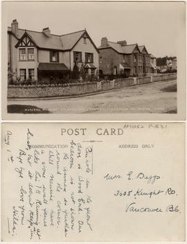
This postcard includes personal correspondence addressed to Mrs. E. Baggs of Vancouver.
![Wolfe [Avenue], 16th [Avenue], Montcalm and Richelieu [Streets] looking south](/uploads/r/null/d/5/d5f4819b02da1747323667a28fcc57017c0028dc79ef9fe0798c76c832e14e52/ee8d0961-08ae-4e20-8264-5f822eb32ef0-A44514_142.jpg)
Wolfe [Avenue], 16th [Avenue], Montcalm and Richelieu [Streets] looking south
Part of City of Vancouver fonds
![Wolfe [Avenue], 16th [Avenue], Montcalm and Richelieu [Streets] looking northwest](/uploads/r/null/b/f/bf972340b2c91c66b6623c0e6e6c9488805a2785a450af4560c99cc64616efc6/8ed5830c-8b6b-46bf-8c18-a5b2171e3647-A44513_142.jpg)
Wolfe [Avenue], 16th [Avenue], Montcalm and Richelieu [Streets] looking northwest
Part of City of Vancouver fonds
![Wolfe [Avenue], 16th [Avenue], Montcalm and Richelieu [Streets] looking east](/uploads/r/null/3/1/3138a2942f3f719f5d026d7a39bf0aec2f3c53b503ca7198eea08ef25ed63571/e232f834-4a48-48e3-b060-f43970d8b093-A44515_142.jpg)
Wolfe [Avenue], 16th [Avenue], Montcalm and Richelieu [Streets] looking east
Part of City of Vancouver fonds
![Wolfe [Avenue], 16th [Avenue], Montcalm and Richelieu [Streets] looking west](/uploads/r/null/c/2/c2e4f7af4d1426b6f918aa6d47d423ba2b716b73f8ac51e46b1a7c5147d276a7/a573cc90-4fa9-4fd9-857f-9905b285fd9a-A44516_142.jpg)
Wolfe [Avenue], 16th [Avenue], Montcalm and Richelieu [Streets] looking west
Part of City of Vancouver fonds

Winter view of 3379 West 22nd Avenue
Part of Dunbar History Project fonds
Item was filed under People and customs.
Winter view of 3379 West 22nd Ave.
Part of Dunbar History Project fonds
Item was filed under People and customs.

Winnipeg, Man., from City Hall looking north
Part of Major Matthews collection
![Windsor [Street] and Kingsway [looking] west](/uploads/r/null/5/7/5722f01edf03c39ca6f7f107e8aed0de2ebcfd3affb65350bd30527f582a2a5c/eacbf42e-0633-4923-9b95-a964c9709c21-A44512_142.jpg)
Windsor [Street] and Kingsway [looking] west
Part of City of Vancouver fonds
![Windsor [Street] and Kingsway [looking] south](/uploads/r/null/1/d/1d660f907031bda7ef74cb2c50e97b947e7bf2eea19407c4e305f3cdb484c309/1f54a002-cbb9-4de4-9aaa-434556f7152b-A44511_142.jpg)
Windsor [Street] and Kingsway [looking] south
Part of City of Vancouver fonds
![Windsor [Street] and Kingsway [looking] north](/uploads/r/null/5/1/51ff473582ed3604eae58884e23fc0b18cc2bacd178e8d2a7ca2cb2620df3bad/f739dee2-1c3e-4240-80fc-9e5a62c612c5-A44509_142.jpg)
Windsor [Street] and Kingsway [looking] north
Part of City of Vancouver fonds
![Windsor [Street] and Kingsway [looking] east](/uploads/r/null/1/1/1108be299e00680f72cdf55a2e7499980cf2334fcfee872fc1712946534afd9f/c61f5347-8fb0-4ce1-aa88-51a3f0aa4be0-A44510_142.jpg)
Windsor [Street] and Kingsway [looking] east
Part of City of Vancouver fonds

Window detail 341 Water Street
![Windermere and Hastings [Streets looking] south](/uploads/r/null/7/9/797f60676737e6ab25e5788913b01c09c9923037f282e0f4bf9370bb15a88213/97793dad-6d76-491b-8503-f5676be35de4-A44507_142.jpg)
Windermere and Hastings [Streets looking] south
Part of City of Vancouver fonds