Vancouver, B.C., the Pacific coast terminus of the C.P.R. [Canadian Pacific Railway]
- AM1594-: MAP 215
- Item
- 1889
Part of City of Vancouver Archives technical and cartographic drawing collection
Item is a map and guide to Vancouver.
111 results with digital objects Show results with digital objects
Vancouver, B.C., the Pacific coast terminus of the C.P.R. [Canadian Pacific Railway]
Part of City of Vancouver Archives technical and cartographic drawing collection
Item is a map and guide to Vancouver.

Vancouver, B.C. 1890 : built-on area
Part of City of Vancouver Archives technical and cartographic drawing collection
Item is a map showing downtown Vancouver and a portion of east Vancouver. City blocks, buildings and railway lines are shown. Annotations in pencil mark the location of Granville Bridge, Main Street Bridge, the Vancouver Lumber Company, the Canadian Pacific Railway station, the Hastings Sawmill, False Creek and Burrard Inlet.
Holdsworth, Derek

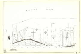
Vancouver and Northern Railway, 1908
Part of City of Vancouver Archives technical and cartographic drawing collection
Item is a portion of a larger topographic map which supposedly has been annotated to show proposed railway routes from North Vancouver, along Howe Sound, to Alta Lake. The annotations have been made on a portion of a topographical map, most likely published by the British Columbia Department of Lands.

Stuart's pocket map of Vancouver, B.C.
Part of City of Vancouver Archives technical and cartographic drawing collection
Item is an illustrated map of the "old" City of Vancouver. The map shows streets, transportation, and significant businesses (such as C.P.R. wharves, smelter, Hastings Mill, Morse's Mill, C.P.R. Shops, City Hospital, sawmill, slaughter houses, and smallpox hospital). The map includes "Index of Streets, Government Offices, Churches, [etc.], including "Civic and other Principal Buildings", "Places of Amusement or Recreation", "Public Schools", "Principal Mills, Foundries and Manufactories", "Principle Bankers", Principal Hotels", and "Miscellaneous".
The map was designed to be folded into a cover, which is included.

Part of City of Vancouver Archives technical and cartographic drawing collection
Item consists of two sections. One shows the area from Milton Street to Heather Street and Seventy-second Avenue to Fraser River; the other shows Angus Drive to Granville Street and South West Marine Drive to Fraser River. Includes streets, roads, railway lines, blocks, lots and legal descriptions.
Vancouver (B.C.). Office of the City Engineer

Part of City of Vancouver Archives technical and cartographic drawing collection
Item is a sheet with two sections. The first section shows the area from Milton Street to Heather Street and Seventy-second Avenue to Fraser River; the second section shows the area from Angus Drive to Granville Street and South West Marine Drive to Fraser River. Sections show streets, roads, blocks, lots and legal descriptions, as well as the location of railway lines, the Eburne Sawmill, and a proposed bridge to Richmond.
Vancouver (B.C.). Office of the City Engineer

Sheet S.V. 9 : St. George Street to Argyle Street and Fifty-eighth Avenue to Fraser River
Part of City of Vancouver Archives technical and cartographic drawing collection
Item is a section showing the area from St. George Street to Argyle Street and Fifty-eighth Avenue to Fraser River. Includes streets, roads, blocks, lots, legal descriptions, railway lines, parks and schools.
Vancouver (B.C.). Office of the City Engineer

Sheet S.V. 5 : Ash Street to St. George Street and Sixty-third Avenue to Fraser River
Part of City of Vancouver Archives technical and cartographic drawing collection
Item is a section showing the area from Ash Street to St. George Street and Sixty-third Avenue to Fraser River. Includes streets, roads, blocks, lots, legal descriptions, parks and railway lines.
Vancouver (B.C.). Office of the City Engineer

Part of City of Vancouver Archives technical and cartographic drawing collection
Item is a section showing the area from Dumfries Street to Fairmont Street and Twenty-seventh Avenue to Thirty-seventh Avenue. Includes streets, roads, blocks, lots, legal descriptions, railway lines, parks and schools. Annotations in green pencil.
Vancouver (B.C.). Office of the City Engineer

Sheet G : Trafalgar Street to Granville Street and Sixteenth Avenue to Nanton Avenue
Part of City of Vancouver Archives technical and cartographic drawing collection
Item is a section showing the area from Trafalgar Street to Granville Street and Sixteenth Avenue to Nanton Avenue. Includes streets, roads and sewers; blocks, lots and legal descriptions; and parks, railway lines and schools.
Vancouver (B.C.). Office of the City Engineer

Sheet G : Trafalgar Street to Granville Street and Sixteenth Avenue to Nanton Avenue
Part of City of Vancouver Archives technical and cartographic drawing collection
Item is a section showing the area from Trafalgar Street to Granville Street and Sixteenth Avenue to Nanton Avenue. Includes streets and roads; blocks, lots and legal descriptions; and parks, schools, railway lines and golf courses.
Vancouver (B.C.). Office of the City Engineer
![[Sheet 9 : Main Street to Clark Drive and Prior Street to Burrard Inlet]](/uploads/r/null/c/a/ca4b4713bea0118fec812e6258afe5c1efa039db74073214703001a47b00f122/5e0d243a-99ae-42aa-8bb3-4a1abe9e1209-MAP339_142.jpg)
[Sheet 9 : Main Street to Clark Drive and Prior Street to Burrard Inlet]
Part of City of Vancouver Archives technical and cartographic drawing collection
Item is a sectional map of a portion of Vancouver showing the area from Main Street to Clark Drive and Prior Street to Burrard Inlet. Includes streets, blocks, lots and legal descriptions, and the locations of parks, schools, railways and piers along the waterfront.

Sheet 9 : Main Street to Clark Drive and Prior Street to Burrard Inlet
Part of City of Vancouver Archives technical and cartographic drawing collection
Item is a section showing the area from Main Street to Clark Drive and Prior Street to Burrard Inlet. Includes streets, blocks, lots and legal descriptions, and the locations of parks, schools, railways and piers along the waterfront.
Vancouver (B.C.). Engineering Services

Sheet 9 : Clark Drive to Slocan Street and Triumph Street to Charles Street
Part of City of Vancouver Archives technical and cartographic drawing collection
Item is a section showing the area from Clark Drive to Slocan Street and Triumph Street to Charles Street. Includes streets and roads, blocks, lots, legal descriptions, railways, parks, schools and drill hall. The Town of Hastings is indicated on the map.
Vancouver (B.C.). Office of the City Engineer
[Sheet 84 : Laurel Street to Main Street and North Arm of Fraser River to Southwest Marine Drive]
Part of City of Vancouver Archives technical and cartographic drawing collection
Item is a sectional map of a portion of Vancouver showing the area from Laurel Street to Main Street and North Arm of the Fraser River to Southwest Marine Drive. Includes streets, blocks, lots and legal descriptions, and the location of the Canadian Pacific Railway line and yard.

Sheet 84 : Laurel Street to Main Street and North Arm of Fraser River to Southwest Marine Drive
Part of City of Vancouver Archives technical and cartographic drawing collection
Item is a section showing the area from Laurel Street to Main Street and North Arm of the Fraser River to Southwest Marine Drive. Includes streets, blocks, lots and legal descriptions, and the location of the Canadian Pacific Railway line and yard.
Vancouver (B.C.). Engineering Services

Part of City of Vancouver Archives technical and cartographic drawing collection
Item is a sectional map of a portion of Vancouver showing the area from Main Street to Tipping Road and Crompton Street and Twigg Island to Southeast Marine Drive. Includes streets, blocks, lots and legal descriptions, and the location of the Canadian Pacific Railway.

Part of City of Vancouver Archives technical and cartographic drawing collection
Item is a section showing the area from Main Street to Tipping Road and Crompton Street and Twigg Island to Southeast Marine Drive. Includes streets, blocks, lots and legal descriptions, and the location of the Canadian Pacific Railway.
Vancouver (B.C.). Engineering Services

Sheet 8 : McLean Drive to Slocan Street and William Street to Seventh Avenue
Part of City of Vancouver Archives technical and cartographic drawing collection
Item is a section showing the area from McLean Drive to Slocan Street and William Street to Seventh Avenue. Includes streets and roads, blocks, lots, legal descriptions, railways, parks, schools and some businesses.
Vancouver (B.C.). Office of the City Engineer
![[Sheet 8 : Main Street to Clark Drive and Alexander Street to Burrard Inlet]](/uploads/r/null/a/1/a10fe461f7836acc659d886d1888eef9d17bfc99d33e474c29ae025ed531b50c/e81d36a6-a6c1-40a5-852b-ef52bfbdb8dd-MAP339_142.jpg)
[Sheet 8 : Main Street to Clark Drive and Alexander Street to Burrard Inlet]
Part of City of Vancouver Archives technical and cartographic drawing collection
Item is a sectional map of a portion of Vancouver showing the area from Main Street to Clark Drive and Alexander Street to Burrard Inlet. Includes streets and blocks, railways, piers and leases along the waterfront.
Sheet 8 : Main Street to Clark Drive and Alexander Street to Burrard Inlet
Part of City of Vancouver Archives technical and cartographic drawing collection
Item is a section showing the area from Main Street to Clark Drive and Alexander Street to Burrard Inlet. Includes streets and blocks, railways, piers and leases along the waterfront.
Vancouver (B.C.). Engineering Services

Sheet 79 : Gladstone Street to Kerr Street and North Arm of Fraser River to Bobolink Avenue
Part of City of Vancouver Archives technical and cartographic drawing collection
Item is a section showing the area from Gladstone Street to Kerr Street and North Arm of Fraser River to Bobolink Avenue. Includes streets, blocks, lots and legal descriptions, and the locations of schools, golf courses and the Canadian Pacific Railway.
Vancouver (B.C.). Engineering Services
![[Sheet 79 : Gladstone Street to Kerr Street and North Arm of Fraser River to Bobolink Avenue]](/uploads/r/null/7/9/79214408afd85e4ab6ccc7eec43ecc85caf5ce5dedb9cfeb219866aa0091a733/7696de5a-3bba-4c2d-bc6c-83bf14bcf845-MAP339_142.jpg)
[Sheet 79 : Gladstone Street to Kerr Street and North Arm of Fraser River to Bobolink Avenue]
Part of City of Vancouver Archives technical and cartographic drawing collection
Item is a sectional map of a portion of Vancouver showing the area from Gladstone Street to Kerr Street and North Arm of Fraser River to Bobolink Avenue. Includes streets, blocks, lots and legal descriptions, and the locations of schools, golf courses and the Canadian Pacific Railway.
![[Sheet 78 : Kerr Street to Ivy Avenue and North Arm of Fraser River to Southeast Marine Drive]](/uploads/r/null/9/0/90c6186a1aa17588ec162078d412440a826f55dc10a9d49f8e74df97a4d3ff6e/0a3e4f49-3d6d-4dec-95f1-08aa42e666d8-MAP339_142.jpg)
[Sheet 78 : Kerr Street to Ivy Avenue and North Arm of Fraser River to Southeast Marine Drive]
Part of City of Vancouver Archives technical and cartographic drawing collection
Item is a sectional map of a portion of Vancouver showing the area from Kerr Street to Ivy Avenue and North Arm of Fraser River to Southeast Marine Drive. Includes streets, blocks, lots and legal descriptions, and the location of the Canadian Pacific Railway.

Sheet 78 : Kerr Street to Ivy Avenue and North Arm of Fraser River to Southeast Marine Drive
Part of City of Vancouver Archives technical and cartographic drawing collection
Item is a section showing the area from Kerr Street to Ivy Avenue and North Arm of Fraser River to Southeast Marine Drive. Includes streets, blocks, lots and legal descriptions, and the location of the Canadian Pacific Railway.
Vancouver (B.C.). Engineering Services

Sheet 70 : Macdonald Street to Cypress Street and Fifty-seventh Avenue to Forty-ninth Avenue
Part of City of Vancouver Archives technical and cartographic drawing collection
Item is a section showing the area from Macdonald Street to Cypress Street and Fifty-seventh Avenue to Forty-ninth Avenue. Includes streets, blocks, lots and legal descriptions, and the locations of golf courses, parks and railways.
Vancouver (B.C.). Engineering Services
![[Sheet 70 : Macdonald Street to Cypress Street and Fifty-seventh Avenue to Forty-ninth Avenue]](/uploads/r/null/f/9/f92d773f16070e3762b2b8519c7993087e55cec394d3c593367dd2f160a3e9ad/b01f6a8d-18a1-4872-b084-475fd79e81da-MAP339_142.jpg)
[Sheet 70 : Macdonald Street to Cypress Street and Fifty-seventh Avenue to Forty-ninth Avenue]
Part of City of Vancouver Archives technical and cartographic drawing collection
Item is a sectional map of a portion of Vancouver showing the area from Macdonald Street to Cypress Street and Fifty-seventh Avenue to Forty-ninth Avenue. Includes streets, blocks, lots and legal descriptions, and the locations of golf courses, parks and railways.

Sheet 7 : Clark Drive to Slocan Street and Seventh Avenue to Eighteenth Avenue
Part of City of Vancouver Archives technical and cartographic drawing collection
Item is a section showing the area from Clark Drive to Slocan Street and Seventh Avenue to Eighteenth Avenue. Includes streets and roads, blocks, lots, legal descriptions, railways, parks and schools. Some annotations have been made in green ink.
Vancouver (B.C.). Office of the City Engineer
![[Sheet 7 : Burrard Street to Main Street and Georgia Viaduct to Burrard Inlet]](/uploads/r/null/c/d/cd235086cbaf81487b8784fb32b6ef913f4fe27305678cd1961adf506324c250/8f72f6bd-1013-48ad-a56c-e6269cb6f5a8-MAP339_142.jpg)
[Sheet 7 : Burrard Street to Main Street and Georgia Viaduct to Burrard Inlet]
Part of City of Vancouver Archives technical and cartographic drawing collection
Item is a sectional map of a portion of Vancouver showing the area from Burrard Street to Main Street and Georgia Viaduct to Burrard Inlet. Includes streets, blocks, lots and legal descriptions, and the locations of parks, beaches, schools, theatres, post office and Canadian Pacific Railway yards and piers.

Sheet 7 : Burrard Street to Main Street and Georgia Viaduct to Burrard Inlet
Part of City of Vancouver Archives technical and cartographic drawing collection
Item is a section showing the area from Burrard Street to Main Street and Georgia Viaduct to Burrard Inlet. Includes streets, blocks, lots and legal descriptions, and the locations of parks, beaches, schools, theatres, post office and Canadian Pacific Railway yards and piers.
Vancouver (B.C.). Engineering Services
![[Sheet 6 : Nicola Street to Beatty Street and English Bay Beach to Georgia Street]](/uploads/r/null/f/2/f2effc97084427c0bd73bae3566d3ad910caaa6e7fb3e5ed9f3ece81bd2ac0a1/f2cc48a6-1195-4dd8-8227-71d36d1791bb-MAP339_142.jpg)
[Sheet 6 : Nicola Street to Beatty Street and English Bay Beach to Georgia Street]
Part of City of Vancouver Archives technical and cartographic drawing collection
Item is a sectional map of a portion of Vancouver showing the area from Nicola Street to Beatty Street and English Bay Beach to Georgia Street. Includes streets, blocks, lots and legal descriptions, and the locations of parks, beaches, schools, hospitals and court house.

Sheet 6 : Nicola Street to Beatty Street and English Bay Beach to Georgia Street
Part of City of Vancouver Archives technical and cartographic drawing collection
Item is a section showing the area from Nicola Street to Beatty Street and English Bay Beach to Georgia Street. Includes streets, blocks, lots and legal descriptions, and the locations of parks, beaches, schools, hospitals and court house.
Vancouver (B.C.). Engineering Services

Sheet 6 : Knight Street to Slocan Street and Eighteenth Avenue to Twenty-ninth Avenue
Part of City of Vancouver Archives technical and cartographic drawing collection
Item is a section showing the area from Knight Street to Slocan Street and Eighteenth Avenue to Twenty-ninth Avenue. Includes streets and roads, blocks, lots, legal descriptions, railways, parks and schools. Some annotations have been made in pencil.
Vancouver (B.C.). Office of the City Engineer

Sheet 6 : Craddock Street to Boundary Road and Twenty-ninth Avenue to Fortieth Avenue
Part of City of Vancouver Archives technical and cartographic drawing collection
Item is a section showing the area from Craddock Street to Boundary Road and Twenty-ninth Avenue to Fortieth Avenue. Includes streets, roads, blocks, lots, legal descriptions, parks. railway lines and schools.
Vancouver (B.C.). Office of the City Engineer
![[Sheet 56 : Doman Street and Joyce Street to Boundary Road and Forty-ninth Avenue to Kingsway]](/uploads/r/null/5/e/5ee0f6b78ce9f3b0e0e39795d6220cd37d587872bad7b41b67f4d29c7cb49d4c/f8a321d6-ea4f-4e1f-85da-6d12e149ea85-MAP339_142.jpg)
[Sheet 56 : Doman Street and Joyce Street to Boundary Road and Forty-ninth Avenue to Kingsway]
Part of City of Vancouver Archives technical and cartographic drawing collection
Item is a sectional map of a portion of Vancouver showing the area from Doman Street and Joyce Street to Boundary Road and Forty-ninth Avenue to Kingsway. Includes streets, blocks, lots and legal descriptions. Also included is Central Park and B.C. Electric Railway tracks in Burnaby.

Sheet 56 : Doman Street and Joyce Street to Boundary Road and Forty-ninth Avenue to Kingsway
Part of City of Vancouver Archives technical and cartographic drawing collection
Item is a section showing the area from Doman Street and Joyce Street to Boundary Road and Forty-ninth Avenue to Kingsway. Includes streets, blocks, lots and legal descriptions. Also included is Central Park and B.C. Electric Railway tracks in Burnaby.
Vancouver (B.C.). Engineering Services

Part of City of Vancouver Archives technical and cartographic drawing collection
Item is a sectional map of a portion of Vancouver showing the area from Cecil Street and McHardy Street to Boundary Road and Kingsway to Monmouth Avenue and Price Street. Includes streets, blocks, lots and legal descriptions, and B.C. Electric Railway line. Also included are streets, blocks and B.C. Electric Railway line in the area from Boundary Road to Patterson Avenue in Burnaby.

Part of City of Vancouver Archives technical and cartographic drawing collection
Item is a section showing the area from Cecil Street and McHardy Street to Boundary Road and Kingsway to Monmouth Avenue and Price Street. Includes streets, blocks, lots and legal descriptions, and B.C. Electric Railway line. Also included are streets, blocks and B.C. Electric Railway line in the area from Boundary Road to Patterson Avenue in Burnaby.
Vancouver (B.C.). Engineering Services

Sheet 5 : Slocan Street to Boundary Road and Seventeenth Avenue to Twenty-ninth Avenue
Part of City of Vancouver Archives technical and cartographic drawing collection
Item is a section showing the area from Slocan Street to Boundary Road and Seventeenth Avenue to Twenty-ninth Avenue. Includes streets and roads, blocks, lots, legal descriptions, railways, parks, schools and the Vancouver Preventorium (for tuberculosis patients).
Vancouver (B.C.). Office of the City Engineer

Sheet 5 : Slocan Street to Boundary Road and Seventeenth Avenue to Twenty-ninth Avenue
Part of City of Vancouver Archives technical and cartographic drawing collection
Item is a section showing the area from Slocan Street to Boundary Road and Seventeenth Avenue to Twenty-ninth Avenue. Includes streets and roads, blocks, lots, legal descriptions, railways, parks, schools and the Vancouver Preventorium (for tuberculosis patients). Some annotations have been made in pencil.
Vancouver (B.C.). Office of the City Engineer

Sheet 49 : Arbutus Street to Oak Street and Thirty-third Avenue to Laurier Avenue
Part of City of Vancouver Archives technical and cartographic drawing collection
Item is a section showing the area from Arbutus Street to Oak Street and Thirty-third Avenue to Laurier Avenue. Includes streets, blocks, lots and legal descriptions, and the locations of parks and schools.
Vancouver (B.C.). Engineering Services
[Sheet 49 : Arbutus Street to Oak Street and Thirty-third Avenue to Laurier Avenue]
Part of City of Vancouver Archives technical and cartographic drawing collection
Item is a sectional map of a portion of Vancouver showing the area from Arbutus Street to Oak Street and Thirty-third Avenue to Laurier Avenue. Includes streets, blocks, lots and legal descriptions, and the locations of parks and schools.

Sheet 44 : Blenheim Street to Arbutus Street and King Edward Avenue to Fourteenth Avenue
Part of City of Vancouver Archives technical and cartographic drawing collection
Item is a section showing the area from Blenheim Street to Arbutus Street and King Edward Avenue to Fourteenth Avenue. Includes streets, blocks, lots and legal descriptions, and the locations of parks, schools and railways.
Vancouver (B.C.). Engineering Services
![[Sheet 44 : Blenheim Street to Arbutus Street and King Edward Avenue to Fourteenth Avenue]](/uploads/r/null/2/f/2fdf5060ec6fdc47756dc75416312dd42047abea2beed2d99f086c73bd0c8726/2fe0f45d-ad6c-46e6-9a9f-50c795523f5f-MAP339_142.jpg)
[Sheet 44 : Blenheim Street to Arbutus Street and King Edward Avenue to Fourteenth Avenue]
Part of City of Vancouver Archives technical and cartographic drawing collection
Item is a sectional map of a portion of Vancouver showing the area from Blenheim Street to Arbutus Street and King Edward Avenue to Fourteenth Avenue. Includes streets, blocks, lots and legal descriptions, and the locations of parks, schools and railways.
![[Sheet 40 : Inverness Street to Nanaimo Street and Twenty-second Avenue to Thirteenth Avenue]](/uploads/r/null/9/3/9367a0c50f6fa513d717a1972b1bac72acde6d41b002fefcf48ddbd8c8122e8a/c7bfac0b-bf44-441b-b059-fd7bbc0bd4a0-MAP339_142.jpg)
[Sheet 40 : Inverness Street to Nanaimo Street and Twenty-second Avenue to Thirteenth Avenue]
Part of City of Vancouver Archives technical and cartographic drawing collection
Item is a sectional map of a portion of Vancouver showing the area from Inverness Street to Nanaimo Street and Twenty-second Avenue to Thirteenth Avenue. Includes streets, blocks, lots and legal descriptions, and the locations of parks, schools and railways.

Sheet 40 : Inverness Street to Nanaimo Street and Twenty-second Avenue to Thirteenth Avenue
Part of City of Vancouver Archives technical and cartographic drawing collection
Item is a section showing the area from Inverness Street to Nanaimo Street and Twenty-second Avenue to Thirteenth Avenue. Includes streets, blocks, lots and legal descriptions, and the locations of parks, schools and railways.
Vancouver (B.C.). Engineering Services