


![Chart of Nepigon [Nipigon] Bay. Lake Superior](/uploads/r/null/e/6/0/e6083525f33c7a6d0dd05f840915433768b0cfaed2c5b564153e3bfb5830f77e/8dd4e8d6-c36f-488f-a1bb-7aea7e098200-LEG1153_142.jpg)


Title and statement of responsibility area
Title proper
Canadian Pacific Railway exploration maps
General material designation
- Cartographic material
Parallel title
Other title information
Title statements of responsibility
Title notes
Level of description
File
Reference code
Edition area
Edition statement
Edition statement of responsibility
Class of material specific details area
Statement of scale (cartographic)
Scale not determinable.
Statement of projection (cartographic)
Statement of coordinates (cartographic)
Statement of scale (architectural)
Issuing jurisdiction and denomination (philatelic)
Dates of creation area
Date(s)
Physical description area
Physical description
7 maps
Publisher's series area
Title proper of publisher's series
Parallel titles of publisher's series
Other title information of publisher's series
Statement of responsibility relating to publisher's series
Numbering within publisher's series
Note on publisher's series
Archival description area
Name of creator
Administrative history
The Canadian Pacific Railway was originally begun as public work by the Department of Railways and Canals under the terms which had been agreed upon at the time British Columbia joined Confederation. The work was taken over and completed by a private company, the Canadian Pacific Railway company (incorporated February 16, 1881), under the land grant system. W.C. Van Horne became the General Manager of the company on 13 December 1881; under his management the railway line was laid from Montreal across the prairies to Western Canada, the last spike being driven in at Craigellachie on 7 November, 1885. The line was soon extended from its westernmost point, at Port Moody, to Vancouver, the first transcontinental train arriving in Vancouver on 23 May, 1887. Much of the work of surveying for the C.P.R. within Vancouver was conducted under L.A. Hamilton. The C.P.R. played a major role in the development of the city of Vancouver, having influenced politics, land development, shipping and other areas.
Custodial history
Scope and content
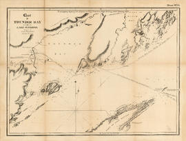
File consists of 7 maps out of a series of at least 16 maps that were created or collected and reproduced to accompany a report of the Chief Engineer of the Candian Pacific Railway in January 1897.