Title and statement of responsibility area
Title proper
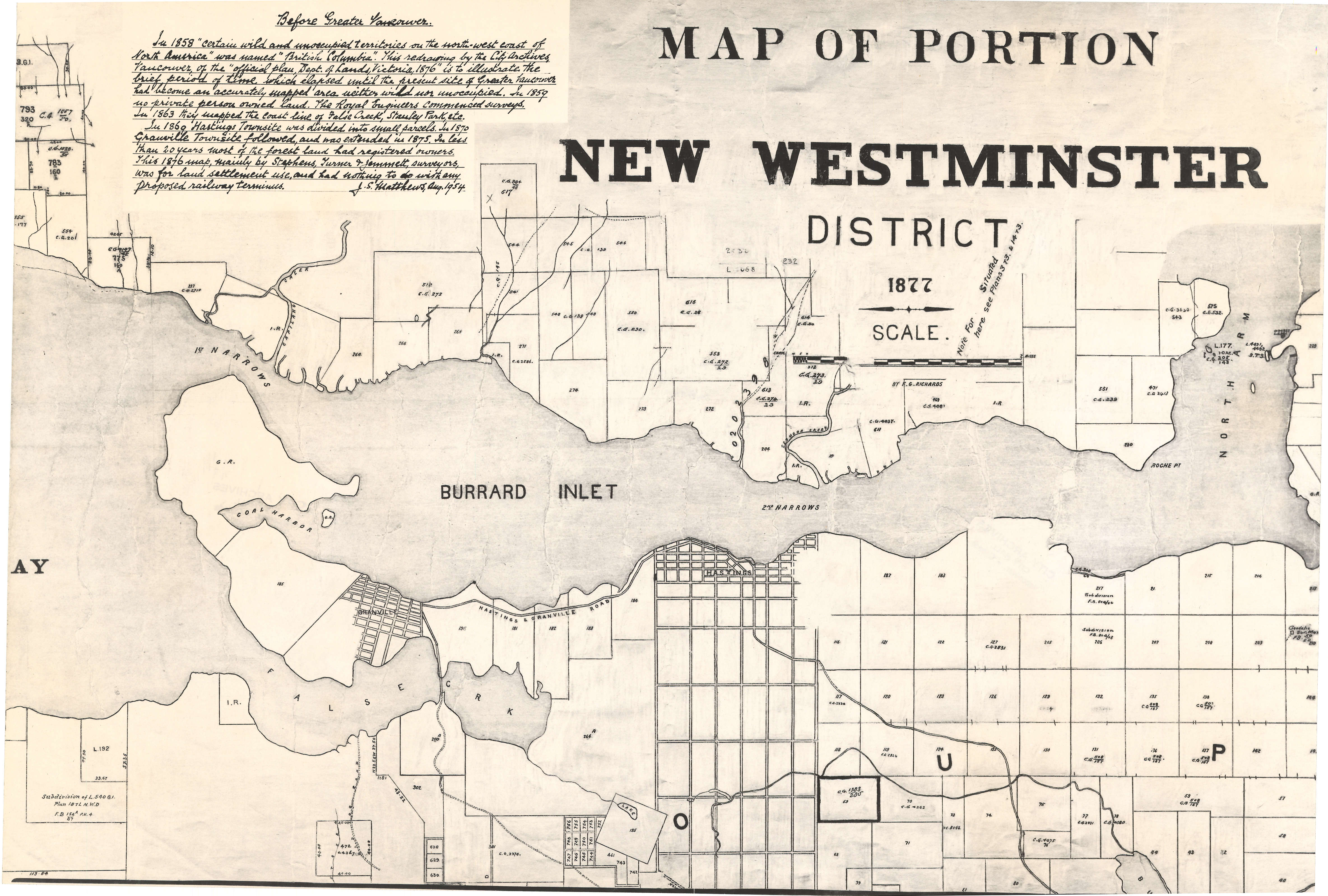
Map of portion New Westminster District
General material designation
- Cartographic material
Parallel title
Other title information
Title statements of responsibility
traced by J.S. Matthews
Title notes
Level of description
Item
Reference code
Edition area
Edition statement
Edition statement of responsibility
Class of material specific details area
Statement of scale (cartographic)
Scale not determinable.
Statement of projection (cartographic)
Statement of coordinates (cartographic)
Statement of scale (architectural)
Issuing jurisdiction and denomination (philatelic)
Dates of creation area
Date(s)
-
1877 (traced 1954) (Publication)
- Publisher
- British Columbia. Department of Lands
- Place
- Victoria (B.C.)
Physical description area
Physical description
1 map : photo-mechanical reproduction, annot. ; 41 x 60 cm
Publisher's series area
Title proper of publisher's series
Parallel titles of publisher's series
Other title information of publisher's series
Statement of responsibility relating to publisher's series
Numbering within publisher's series
Note on publisher's series
Archival description area
Name of creator
Custodial history
Scope and content
Item is an annotated tracing of a map showing the future sites of Vancouver, Burnaby and the North Shore from an area bordering on English Bay to an area bordering on North Arm. Traced over by J.S. Matthews in 1954, it illustrates intended land settlement and subdivision in 1877. Also shown are bodies of water, Hastings & Granville Road, and the settlements of Hastings and Granville. Annotations are an introductory note by Matthews in August 1954 titled "Before Greater Vancouver." Enclosed with the map are four letters between J.S. Matthews and W.H. Hutchinson, Chief of the Geographic Division of the B.C. Survey and Mapping Branch of the Department of Lands and Forests, in 1954 concerning the map's provenance and Matthew's efforts to increase the legibility of copies of the original map.
Notes area
Physical condition
Immediate source of acquisition
Arrangement
Map had previously been alienated from its original fonds and placed in AM1594.
Language of material
Script of material
Location of originals
Availability of other formats
A digitized copy of this material is available on-line.
Restrictions on access
Terms governing use, reproduction, and publication
Finding aids
Associated materials
Map 1055.02 is the original photocopied map on which J.S. Matthews made the tracings in white pen and darkened the background in an attempt to improve legibility. Correspondence relating to this map can be found at 847-A-3, folder 38.
Accruals
General note
In the AM54-S13 inventory, was part of Oblong S.69.
External Link
ftp://webftp.vancouver.ca/archives/MAPS-TIFF/MAP1055.01.tif
Format: TIFF (LZW compressed)
MD5: C50BE0E4CE4C3AAAA0973B18213FACD2
*Size: 30244284 bytes
Rights
Public domain
Alternative identifier(s)
Standard number area
Standard number
Access points
Subject access points
Place access points
Name access points
- British Columbia. Department of Lands (Publisher)