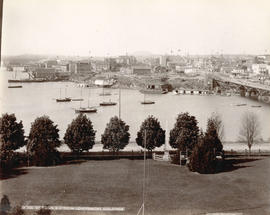
![[View of Victoria Harbour an] Parliament Buildings](/uploads/r/null/9/2/92c1339ecc880e2165a05beaee358355b4c5da0b6c0f0d6742919864aa275115/1498ef9f-3d2b-4af3-b61e-dfaa48987973-A07157_142.jpg)
[View of Victoria Harbour an] Parliament Buildings
- AM1545-S3-: CVA 586-477
- Item
- 1940
462 results with digital objects Show results with digital objects
[View of Victoria Harbour an] Parliament Buildings

Scenes : Vancouver Harbour and skyline etc.

Rail journey through the Rocky Mountains, Victoria, and dog show
Part of Samuel S. Magoffin fonds
Item is an amateur film opening with footage of downtown Vancouver showing several Vancouver Fire Department trucks and engines and a lot filled with lumber, then cutting to footage taken from the back of a moving train, showing snow covered scenery, followed by Sam and Margaret Magoffin standing on a porch with several other people and a dog, Margaret and a man standing in front of a car, and additional footage taken from a moving train showing a sign for Yoho, mountain scenery and the Cathedral train station. The film also contains footage taken in downtown Victoria, B.C. showing the legislative building, Inner Harbour and CPR Steamship Terminal building, followed by dogs, likely the Magoffin’s golden retrievers, and several minutes footage of a dog show.

Provincial Reports - "That's The BC Spirit"
Part of Yaletown Productions Inc. fonds
Item is a sponsored production produced by Yaletown Productions Inc. Item consists of ten, two minute, "Province Reports," with Fred Latrimouille, produced by Yaletown Productions for the government of British Columbia's "B.C. Enterprise" program. In the order that they appear on the tape they are:
-Province Report 2 "People Place/Jobs" (Oct. 5, 1982)
-Province Report 7 "Burden /Restraint" (Oct. 5, 1982)
-Province Report 9 "Teamwork/Employment Initiatives" with Grace McCarthy, Minister of Human Resources (Oct. 5, 1982)
-Province Report 10 "Getting around/Transportation" (Oct. 5, 1982)
-Province Report 11 "Future jobs/Education" (Oct. 5, 1982)| Province Report 1 "Mega projects/Jobs" (Sept. 20, 1982)
-Province Report 3 "Coalscene/Resource Mgmnt [management]" (Sept. 20, 1982)
-Province Report 4 "Transportation/Ports" (Sept. 20, 1982)
-Province Report 6 "Work share/Jobs" (Sept. 20, 1982)
-Province Report 8 "Foundations/Economic strategy" (Sept. 20, 1982)
Recording includes interview clips with various provincial politicians including Stephen Rogers, William Vander Zalm, James Hewitt, Don Phillips, Grace McCarthy and others.
Allscreen - Vancouver - reel #5
Part of Yaletown Productions Inc. fonds
Film consists of raw footage of Vancouver that was used in video post card "Vancouver - The World in a City." Footage includes scenes of the Lynn Valley suspension bridge, the Grouse Mountain 'Skyride' (gondola), views from Grouse Mountain of the Lower Mainland, the Expo 86 site under construction, B.C. Place Stadium, the Expo Centre (now the Telus World of Science) under construction, and people walking in downtown Vancouver, City Hall, Simon Fraser University campus in Burnaby B.C., and the University of British Columbia campus, Silent film.

Part of Yaletown Productions Inc. fonds
Item is a tourist promotional video for travelling in Alaska. Features shots showing off the Alaskan landscape, following a train of tourists on their route to Northern Alaska. Includes footage of dogsledding and snowmobiling. Video has a predominantly country music soundtrack. Dubbed in Japanese with Japanese title screens and Japanese credits.
NHK [Nippon Hoso Kyokai; official English name: Japan Broadcasting Corporation]
North Vancouver-Vancouver ferry schedule : January 13, April 28, April 29, 1969
The Vancouver Harbour : a preliminary position paper
![[Japanese sailing vessel in Vancouver harbour]](/uploads/r/null/6/1/615722a6da22cd03e9c4c0a3c5a9e5e6e9d40ec814b9d461ae00ff9f79998ffe/d2b7e6ef-acc3-4201-afe4-ab04642e0307-A37903_142.jpg)
[Japanese sailing vessel in Vancouver harbour]

Item shows Coal Harbour looking toward downtown.
Victoria, B.C. from Government Buildings
Photograph shows the Sir James Douglas obelisk

Downtown Vancouver from high vantage point
Item is a photograph of downtown Vancouver looking northwest from the upper floors of an unidentified building. The view includes the Marine Building, Coal Harbour, Vancouver Harbour, and the north shore.

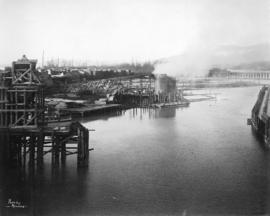
Item is a photograph of an unidentified freighter loading lumber at a pier in Vancouver.

Vancouver Water Front, Vancouver, B.C. (Canada)
Item is a postcard showing Coal Harbour. Caption on back of photograph: "View taken from Stanley Park showing Coal Harbour. In the foreground are boats belonging to the Burrard Yacht Club. In the background can be seen the Marine Building, the tallest in Vancouver, and part of the skyline." The back of the postcard includes personal correspondence addressed to Mr. and Mrs. C.W. McClain.

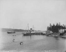
Victoria Harbour from C.P.R. Hotel, Victoria, B.C.
Item is a postcard showing the Victoria Harbour. The back of the postcard includes personal correspondence addressed to Miss Buhman.
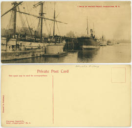
1 mile of water front, Vancouver, B.C.
By-laws of the National Harbours Board (Vancouver Harbour)
What is the National Harbours Board?
![Vancouver Harbour Sept. 1913 [showing the C.P.R. Station and yard and Pier D under construction]](/uploads/r/null/0/5/056455d9e690740168b8f4ae0d8d18b148b46061376f6b258e46b96ab0527cb1/82d16629-54f2-49c5-9a22-bf507e3921f0-A63186_142.jpg)
Vancouver Harbour Sept. 1913 [showing the C.P.R. Station and yard and Pier D under construction]
Part of Major Matthews collection
![["Komagata Maru" surrounded by small boats in Vancouver harbour]](/uploads/r/null/d/3/d31c324995f87c0ded566d258697e7eb123efabed869b13a93bc7eb9b13e7257/c5bef304-61c9-4b03-93a7-01560bf818ab-A08342_142.jpg)
["Komagata Maru" surrounded by small boats in Vancouver harbour]
Part of Major Matthews collection
Photograph negative consists of two images, side by side. J.S. Matthews' notes with print or negative in Archives.
![[Northward view of Downtown Vancouver from the tower of the Vancouver Block]](/uploads/r/null/7/e/7e88d0ca5a3c8b27417b0772731b3b9c8e8116caba7efef77325c3bfdf9ef14d/7ff76790-0eb3-4328-b584-8e7978589537-A63884_142.jpg)
[Northward view of Downtown Vancouver from the tower of the Vancouver Block]
Part of Major Matthews collection
Photograph also shows the upper floors and the roof garden of the second Hotel Vancouver, Burrard Inlet and the North Shore in the background.
![[East half Granville Island before filling]](/uploads/r/null/3/5/35c9254407dcb353fee92a4f8f428fb575c8c83ae212ce77b57e6ecf0bbb2b9f/2b18b1d3-56f8-4e24-89f3-345aa9ea9358-A31772_142.jpg)
[East half Granville Island before filling]
Part of Major Matthews collection

East half Granville Island before filling
Part of Major Matthews collection
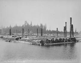
File shows harbour, log boom and industrial shoreline.

East half Granville Island before filling
Part of Major Matthews collection
West half Granville Island before filling
Part of Major Matthews collection
![[Parliament Buildings, Victoria, B.C.]](/uploads/r/null/d/0/d0f3827fcba74f71918e13419e6a10f2abbb53aad9ccd3b6e764a59a8e42e0d6/58091dda-eca1-43d9-83d4-2ad2d2a77bb5-A04350_142.jpg)
[Parliament Buildings, Victoria, B.C.]
Part of Major Matthews collection
J.S. Matthews' notes with print or negative in Archives.
![[Queen Victoria Memorial Fountain]](/uploads/r/null/f/b/c/fbc8607cfbb0c77b361e1848d986e2ef78b715bb554ba8a0769d86d3e082ed38/bebd2627-01c5-42b2-9d75-24f222aaf42d-MonP32_142.jpg)
[Queen Victoria Memorial Fountain]
Part of Major Matthews collection
Panoramic view shows Coal Harbour, Deadman's Island
![[Replica Boeing B&W-1 float plane on Coal Harbour]](/uploads/r/null/3/2/32025b8403038a739a5d027251034c50ae7df3bb3146e0ffddd172cfea4af1b9/cb8061f3-67db-4d22-8d79-2d54221ef558-A23525_142.jpg)
[Replica Boeing B&W-1 float plane on Coal Harbour]
Part of Major Matthews collection
Photograph shows the Royal Vancouver Yacht Club. The event commemorates the 50th anniversary of the first mail flight from Canada to the United States.
Vancouver Harbour [sectional map]
Part of City of Vancouver Archives technical and cartographic drawing collection
File contains 42 maps showing soundings, harbour headlines, high water marks, shore lines, shoals, submarine cable, rail lines and trails in the Vancouver area. Maps also show names of businesses and other structures.

Part of City of Vancouver Archives technical and cartographic drawing collection
Item is a sheet with three nautical charts. The main chart depicts Burrard Inlet from Atkinson Point [Point Atkinson] in the west to the "townsite of Port Moody" in the east. The inset charts depict Vancouver Harbour and the Second Narrows.
The Port of Vancouver : Canada's key city of the West
Part of City of Vancouver Archives technical and cartographic drawing collection
Item is a brochure promoting Vancouver harbour as a hub of economic activity in the city. The brochure includes illustrations of harbour activity, facts about various aspects of the operations to show the harbour's capacity and facilities.
![Granville [Townsite], B.C. Aug., 1885](/uploads/r/null/1/a/4/1a45ddd637fe3f3726748d5096017a8461446b9a013c408ed2b1666c8433e1f9/405fdc0d-6d88-41b7-937f-36cc7f51518a-MAP553_142.jpg)
Granville [Townsite], B.C. Aug., 1885
Part of City of Vancouver Archives technical and cartographic drawing collection
Item is a fire insurance map of the "Coal Harbour" [south shore of Burrard Inlet] area. The Hastings Saw Mill Company and Coal Harbour Fishery are shown in detail. Other businesses along Front Street are identified including hotels and stores.

Map of the harbour of New Westminster, British Columbia
Part of City of Vancouver Archives technical and cartographic drawing collection
Item is a map showing the Fraser River and its North Arm as well as the Westminster Waterway surrounding New Westminster. A key map shows the location of New Westminster in relation to the Greater Vancouver area.

Port of the City of Vancouver. Isometric view from the south-west
Part of City of Vancouver Archives technical and cartographic drawing collection
Item is a set of maps printed on one sheet. The main map shows an isometric view of the port of Vancouver from Stanley Park through the Second Narrows Bridge (including North Vancouver). The perspective point appears to be located above the Granviile Street and West Georgia Street intersection. Note that the isometric view of locations west of Granville Street is from the south-east, rather than the south-west, as indicated in the title.
The map depicts the port infrastructure, including piers, drydocks and companies located in the port.
The inset maps are a key plan showing the location of the port relative to the Lower Mainland as a whole, and a larger-scale map entitled "Plan of the Port of the City of Vancouver from Coal Harbour to Second Narrows". It contains more detail about the names of the various piers, drydocks and companies and shows the North Vancouver port facilities as well as south shore ones.
![[View of Coal Harbour from the causeway]](/uploads/r/null/a/1/a11c5844a676582424273c284cfec188f2dfc6c90cb9dd46a741be593d2a3456/caed5a3c-25db-483c-8ad9-fde5e565c38b-A75614_142.jpg)
[View of Coal Harbour from the causeway]
Part of James Crookall fonds
![Pender Harbour showing [S.S.] "Comox"](/uploads/r/null/a/8/a830ad06450de793e74a3abcd7300572c52301769d6143086b9a050810f238d5/0c246306-10a0-4982-853f-19c126520072-A76290_142.jpg)
Pender Harbour showing [S.S.] "Comox"
Part of James Crookall fonds
Part of John William Freeston fonds
Panoramic view showing fuel oil tanks at the foot of Bute Street, Coal Harbour, the Vancouver Rowing Club, Deadmans Island, Brockton Point, the C.P.R. freight car ferry dock, the Immigration building, C.P.R. Pier A and Pender Street west of Burrard Street

Part of John William Freeston fonds
Panoramic view showing the inner harbour, The Empress Hotel and Government Street, the Grand Truck Pacific and other docks and the cupolas of the parliament buildings

View of Vancouver Harbour from Tower Building
Part of John William Freeston fonds
Panoramic view from taken from on top of the Tower building at 500 Beatty street looking northwest and northeast showing such sites as the Universal Knitting Company, the Bank of Hamiltion, Spencers Department Store, the Dominion Building, the Leckie Boot Company, Woodwards water tower, Orpheum Theatre, Pantages Hotel, McLennan and McFeely Co., Pier D, the Union Steam Ship dock and the wharves east and Brockton Point and Burrard Inlet in the background. Photograph also shows various billboards and painted advertisements such as Britannia Beer.
![[Dominion Day yacht regatta in Coal Harbour]](/uploads/r/null/d/e/de027b7418d095270d7d76f9c609f3d924507203208849d0fc2b36ca166162c2/1153f149-4cdb-4ca6-aa6d-2976c0a1f3ef-A23868_142.jpg)
[Dominion Day yacht regatta in Coal Harbour]
Part of Major Matthews collection
Photograph shows British warships in background
![[Aerial view of Vancouver Harbour from Stanley Park looking east to Indian Arm]](/uploads/r/null/c/b/cb066fdc626d69001bfb4c896937f586737298cc09ee0de3cc7fdd0bca8df09e/93414b9d-edd5-4e76-a79d-fb7a26360472-A31831_142.jpg)
[Aerial view of Vancouver Harbour from Stanley Park looking east to Indian Arm]
Part of Major Matthews collection
Oblique view
![[C.P.R. Royal Mail ship "Empress of Japan" leaving Vancouver Harbour]](/uploads/r/null/c/0/c05cfe11a2709216a9ae3f057fcb5e8bbad06d44125b6c4e82d066b52864d525/0289afa5-94fe-457e-bc67-09ad52578e50-A08768_142.jpg)
[C.P.R. Royal Mail ship "Empress of Japan" leaving Vancouver Harbour]
Part of Major Matthews collection
J.S. Matthews' notes with print or negative in Archives.
![[View of Burrard Inlet from Point Grey]](/uploads/r/null/e/3/e320d8072b352225b343a6bf036a24dfbe3d1f2d722001dd0b12d0aa899d36bb/bb12fe87-3475-4839-9e59-891393008d05-A64782_142.jpg)
[View of Burrard Inlet from Point Grey]
Part of Major Matthews collection
Panoramic view showing a pier and Stanley Park in background.
![[View of Coal Harbour and the rear of Queen Victoria's Memorial from Stanley Park]](/uploads/r/null/4/3/43de497a997e0f724c44d286a5777cf01177bc80cf064bb190ff8d322f1a3431/ab850521-fb13-4aa6-8b76-7ae76dab47a7-A64524_142.jpg)
[View of Coal Harbour and the rear of Queen Victoria's Memorial from Stanley Park]
Part of Major Matthews collection
Photograph also shows two boys and boats anchored in the harbour.

City and Deadman's Island near Nine 0'Clock Gun
Part of Major Matthews collection
Vancouver Harbour : plan of south shore, Burrard Inlet between Heatley Ave. and Victoria Dr.
Part of City of Vancouver Archives technical and cartographic drawing collection
Item is a map which shows parcels of land along Burrard Inlet and district lots in downtown Vancouver. Piers, factories and mills along the waterfront are identified. Soundings are shown in feet.