- PUB-: PD 2154
- Item
- [ca. 1975]
Part of City publications collection
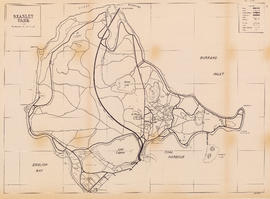
Item is a map showing roads, trails, walkways, parking lots, buildings, shorelines, creeks, and swamps in Stanley Park.
Part of City publications collection
Item is a map showing roads, trails, walkways, parking lots, buildings, shorelines, creeks, and swamps in Stanley Park.

Zoning Map: City of Vancouver, British Columbia
Part of City publications collection
Item is a zoning map showing different zoning districts of Vancouver in 1974. Map has a plastic overlay shows local areas.

Downtown peninsula - Vancouver, B.C. : contour lines at 10 foot intervals, datum line - 100
Part of City publications collection

Vancouver low cost street program
Part of City publications collection
Item is an educational film documenting Vancouver's low cost street program to improve the amenity of urban areas. Film documents the before and after shots of city streets that had been improved. Film was used for a presentation about the program.

Map of City of Vancouver showing schools, parks, community centres, libraries, health units
Part of City publications collection
Item is a map designed to be folded into a pamphlet. Pamphlet covers (on verso of map) give map title and credit the City of Vancouver as publisher of the map.

Zoning Map: City of Vancouver, British Columbia
Part of City publications collection
Item is a zoning map showing different zoning districts of Vancouver in 1969.

Part of City publications collection
Item is a map showing proposed commercial and residential zones and the location of an elementary school in the area directly south of Simon Fraser University. Base map shows land use for the area bounded by Willingdon Avenue, North Road, Barnet Road, and the Trans-Canada Highway.

Official Regional Plan : proposed amendments within the City of Vancouver
Part of City publications collection
Item is a map showing proposed amendments to industrial and rural zoning areas.

Zoning Map: City of Vancouver, British Columbia
Part of City publications collection
Item is a zoning map showing different zoning districts of Vancouver in 1963.

Zoning Map: City of Vancouver, British Columbia
Part of City publications collection
Item is a zoning map showing different zoning districts of Vancouver in 1960.

Part of City publications collection

One way streets : illustrations of special intersections
Part of City publications collection
Part contains pamphlet cover and illustrations showing traffic flow at the intersections of Robson Street and Cambie Street, Richards Street, Water Street, and Cordova Street, and Beatty Street and Pender Street

One way streets : Illustrated map of Downtown Vancouver
Part of City publications collection
Part contains an illustrated map of Downtown Vancouver showing traffic flow along new one-way streets. Illustration has been annotated with address block numbers and continuations of streets directly east of Main Street.
![Sheet 1B [Boundary Road to Burrard Inlet to Rupert Street to Cambridge Street]](/uploads/r/null/2/d/e/2de8a9356c43bdf5c2000524f0160e69ebb4155a087c48253380abd411347e98/c0871cff-d576-48da-93e7-50334a7f3bfe-LEG1153_142.jpg)
Sheet 1B [Boundary Road to Burrard Inlet to Rupert Street to Cambridge Street]
Part of City publications collection
![Sheet 2B [Boundary Road to Pender Street to Windermere Street to Charles Street]](/uploads/r/null/6/d/d/6dd321f1933530c0449917d5fdeb9ddeadff6b12ddc423a9f60d2633579ba2f1/e16c6545-d33e-4bf8-93d8-24f9847c06ac-LEG1153_142.jpg)
Sheet 2B [Boundary Road to Pender Street to Windermere Street to Charles Street]
Part of City publications collection
![Sheet 2C [Windermere Street to Charles Street to Slocan Street to 5th Avenue]](/uploads/r/null/5/c/3/5c31b68277d535d0bf8c13023079d05dfe1fb535497b50e8f264465db169ce22/3a1ef444-0d14-4f3d-aaa7-27bc65dc7224-LEG1153_142.jpg)
Sheet 2C [Windermere Street to Charles Street to Slocan Street to 5th Avenue]
Part of City publications collection
![Sheet 4A [Windermere Street to 22nd Avenue to Slocan Street to 29th Avenue]](/uploads/r/null/a/d/f/adf64a2e43a5bbd7b7b6359d2dfbb3ff89b5ac7e2947a14033383119422d0069/643362ca-2df8-48bd-9f04-c5af1d6505f1-LEG1153_142.jpg)
Sheet 4A [Windermere Street to 22nd Avenue to Slocan Street to 29th Avenue]
Part of City publications collection
![Sheet 4C [Spencer Street to 29th Avenue to Slocan Street to Kingsway Avenue]](/uploads/r/null/0/c/1/0c1c1eea769ffe690bcd89398f43463c8f8019dacc5ed2883d8a0f82728d4559/dc190b53-9756-4e8e-ac6f-ec929e1e7f01-LEG1153_142.jpg)
Sheet 4C [Spencer Street to 29th Avenue to Slocan Street to Kingsway Avenue]
Part of City publications collection
![Sheet 5A [McKinnon Street to Kingsway Avenue to Wales Street to 45th Avenue]](/uploads/r/null/e/8/a/e8a898c0e8b3b2f26130948113540327f8be8bf9b6cc9f24dcf2a87dd8475188/e2ed686c-e99a-4a73-a462-257126de47b2-LEG1153_142.jpg)
Sheet 5A [McKinnon Street to Kingsway Avenue to Wales Street to 45th Avenue]
Part of City publications collection
![Sheet 5C [Doman Street to 45th Avenue to Vivian Street to 52nd Avenue]](/uploads/r/null/0/f/4/0f44f7b43fd58c096ccc443d651cbc43d9aadeac3e13e7b6863a8914a79bd80d/1486eb87-cda0-4a49-b822-95368cce1f7a-LEG1153_142.jpg)
Sheet 5C [Doman Street to 45th Avenue to Vivian Street to 52nd Avenue]
Part of City publications collection
![Sheet 6D [Boundary Road to 61st Avenue to Kinross Street to Ellis Avenue]](/uploads/r/null/c/a/1/ca18897f165b8c9fc64a0a090824a17dd124c7fd9eaa4b86b2ef3043e96ae6da/0f219d9c-5616-4b1e-8103-33d6770ccf02-LEG1153_142.jpg)
Sheet 6D [Boundary Road to 61st Avenue to Kinross Street to Ellis Avenue]
Part of City publications collection
![Sheet 8D [Slocan Street to Charles Street to Semlin Drive to 6th Avenue]](/uploads/r/null/9/f/b/9fb954e03525c1c5f3722cf6d1f3b0e0d9ae28c2a0ed307fa25ca0dc6ac46434/416c089e-39ae-49d3-a4fc-472175911de5-LEG1153_142.jpg)
Sheet 8D [Slocan Street to Charles Street to Semlin Drive to 6th Avenue]
Part of City publications collection
![Sheet 10A [Sydney Street to 22nd Avenue to Knight Street to 28th Avenue]](/uploads/r/null/6/8/a/68a5ee3c33e4a16ab15608383f6f4c59030ccb98434d74a4b9841d8baeb01a4f/797e1ea9-b769-4c53-a498-ddc837d8d6b0-LEG1153_142.jpg)
Sheet 10A [Sydney Street to 22nd Avenue to Knight Street to 28th Avenue]
Part of City publications collection
![Sheet 10C [Gladstone Srteet to 29th Avenue to Knight Street to 37th Avenue]](/uploads/r/null/e/e/6/ee677093b334dfa6504db28523f8861a78222a2259d95572fe2ef5131318e857/8a482765-fdbe-4162-9d22-e5bd1c6e3ff2-LEG1153_142.jpg)
Sheet 10C [Gladstone Srteet to 29th Avenue to Knight Street to 37th Avenue]
Part of City publications collection
![Sheet 11B [Wales Street to 37th Avenue to Victoria Drive to 45th Street]](/uploads/r/null/1/0/e/10e216d966349146e6c8bcd323ab9c23bd8d76a41fb67e813dc85c3b45d02a85/67f3269b-d839-420f-a865-7504f4573fae-LEG1153_142.jpg)
Sheet 11B [Wales Street to 37th Avenue to Victoria Drive to 45th Street]
Part of City publications collection
![Sheet 13C [Kinross Street to Kent Avenue to Jellicoe Street to Fraser River]](/uploads/r/null/3/5/2/352b07afbc524c7ddccf37b3e3d97b12d5c0be97fad31325d508b5732250a89b/bbf4f6ac-22ae-415d-9327-d6623a7779a9-LEG1153_142.jpg)
Sheet 13C [Kinross Street to Kent Avenue to Jellicoe Street to Fraser River]
Part of City publications collection
![Sheet 14B [Clark Drive to Burrard Inlet to Kawks Avenue to Powell Street]](/uploads/r/null/8/0/7/807b43d4c6da80a78ccf0b257afc77acb7f28fd695221ce80613ebc9f968a0f5/79d752d8-de33-4bad-b374-15b82083bc6f-LEG1153_142.jpg)
Sheet 14B [Clark Drive to Burrard Inlet to Kawks Avenue to Powell Street]
Part of City publications collection
![Sheet 16D [Knight Street to 16th Avenue to Fraser Street to King Edward Avenue]](/uploads/r/null/5/0/1/5011c29f81b0d7a5d44c56d2ca55bafb60ba5cbf140db322b6645c3c623d3bfe/0fc650fb-612f-43cf-bcf2-f27bcd72fc10-LEG1153_142.jpg)
Sheet 16D [Knight Street to 16th Avenue to Fraser Street to King Edward Avenue]
Part of City publications collection
![Sheet 19B [Knight Street to 57th Avenue to Fraser Street to SE Marine Drive]](/uploads/r/null/4/f/5/4f5da15126a4ce02e32ae9838f5a5bdecd4f5a2b191ce8fb6e4c06210812304f/27cf1dda-8922-4f55-a844-84c33a9bcc99-LEG1153_142.jpg)
Sheet 19B [Knight Street to 57th Avenue to Fraser Street to SE Marine Drive]
Part of City publications collection
![Sheet 22C [Main Street to False Creek to Cambie Street to Broadway]](/uploads/r/null/7/3/a/73aeed92b2e9c6ce807050f51de860169822128be2ddf43e82922bff57680f2c/f799bc3c-035d-4000-a3a2-3bf4d17f7a59-LEG1153_142.jpg)
Sheet 22C [Main Street to False Creek to Cambie Street to Broadway]
Part of City publications collection
![Sheet 23A [Cambie Street to Broadway to Oak Street to 16th Avenue]](/uploads/r/null/6/1/1/611d70d679c117234587b2a2e1b6be67300a2253ef2e44cd09bbb6600209bf9d/12668210-1f00-40cd-9e6a-962601202c0e-LEG1153_142.jpg)
Sheet 23A [Cambie Street to Broadway to Oak Street to 16th Avenue]
Part of City publications collection
![Sheet 23B [Main Street to Broadway to Cambie Street to 16th Avenue]](/uploads/r/null/a/8/8/a88275106a606ed36a3beb25301ded9af2e493e24e678db2f274a3673bad6974/e0810195-9858-4854-9ced-43cc6c076393-LEG1153_142.jpg)
Sheet 23B [Main Street to Broadway to Cambie Street to 16th Avenue]
Part of City publications collection
![Sheet 23D [Main Street to 16th Avenue to Cambie Street to King Edward Avenue]](/uploads/r/null/b/4/b/b4b8f4cde1ef522c8244aa312f9fa1eca121a177836b82353d0624b38f755734/79860ff2-e7a8-47f0-83d4-0079257693fc-LEG1153_142.jpg)
Sheet 23D [Main Street to 16th Avenue to Cambie Street to King Edward Avenue]
Part of City publications collection
![Sheet 24D [Main Street to 33rd Avenue to Alberta Street to 41st Avenue]](/uploads/r/null/7/2/0/72045195180951bd22be7f85ce64df6d157f0f74c2343e0c6602d049e4a9baf9/ba160e24-45db-4759-ab5c-208721252591-LEG1153_142.jpg)
Sheet 24D [Main Street to 33rd Avenue to Alberta Street to 41st Avenue]
Part of City publications collection
![Sheet 25B [Quebec Street to 41st Avenue to Cambie Street to 49th Avenue]](/uploads/r/null/c/4/3/c43326122e2a0ea99a1eee7e9e81b01dc85abf6a428261a78133f94cd4d3a646/8dafe466-2d5d-4319-b137-3983faeae6f3-LEG1153_142.jpg)
Sheet 25B [Quebec Street to 41st Avenue to Cambie Street to 49th Avenue]
Part of City publications collection
![Sheet 26B [Main Street to 57th Avenue to Yukon Street to SW Marine Drive]](/uploads/r/null/c/6/e/c6e2ab7bfcb2c00023393e64eaa154c634439810f61e635071fd2c52aca345a3/71fa975e-e98a-4e9c-a2a3-e2eaa7433ee2-LEG1153_142.jpg)
Sheet 26B [Main Street to 57th Avenue to Yukon Street to SW Marine Drive]
Part of City publications collection
![Sheet 28A [Granville Street to Broadway to Arbutus Street to 16th Avenue]](/uploads/r/null/1/7/f/17fd01c212b9a2b80920646d75687fd4b98975e8e1d4b3c1d7d68a1a43cd805f/5aa16143-96df-4d15-991e-d00debbd9e41-LEG1153_142.jpg)
Sheet 28A [Granville Street to Broadway to Arbutus Street to 16th Avenue]
Part of City publications collection
![Sheet 29B [Oak Street to King Edward Avenue to Granville Street to 33rd Avenue]](/uploads/r/null/6/6/c/66c313529026b3bfd15c600bfe7b028fbc1ad337c8ae8f888c8290601edd3cf2/6cf54ca6-f0ac-4ee5-b8b2-a1bde53b92e2-LEG1153_142.jpg)
Sheet 29B [Oak Street to King Edward Avenue to Granville Street to 33rd Avenue]
Part of City publications collection
![Sheet 30B [Oak Street to 41st Avenue to Granville Street to 49th Avenue]](/uploads/r/null/5/c/b/5cb62caf7e3659ed91d4f6b4e8d04298a49ea961e6ee8c5fcfeb42fe9bf72540/c25faa0d-4421-4636-971e-2f50ab1fc56e-LEG1153_142.jpg)
Sheet 30B [Oak Street to 41st Avenue to Granville Street to 49th Avenue]
Part of City publications collection
![Sheet 31C [Granville Street to 64th Avenue to Arbutus Street to 75th Avenue]](/uploads/r/null/7/5/f/75f249b5fc579aa03802501fa3f06e9fb4e16a33a9ef5f9b20588410faafe27d/7bd5ecfa-efd5-40d2-9eb7-6bcf9d910eee-LEG1153_142.jpg)
Sheet 31C [Granville Street to 64th Avenue to Arbutus Street to 75th Avenue]
Part of City publications collection
![Sheet 31D [Fremlin Street to 64th Avenue to Granville Street to 72nd Avenue]](/uploads/r/null/5/d/3/5d365e7cf45c2b5a8c10f20be26c5422a9a4252b0f34d7849f55613bb64cd1be/c7a8ff4c-168e-46d8-ad89-2e74a83832ae-LEG1153_142.jpg)
Sheet 31D [Fremlin Street to 64th Avenue to Granville Street to 72nd Avenue]
Part of City publications collection
![Sheet 32B [Oak Street to 72nd Avenue to Granville Street to Fraser River]](/uploads/r/null/2/7/5/275d6880f3ea7523436002a4fd856810a10d9cfbca4bec7fdb8f9cd67ff66d27/eb4a1afb-8340-43d9-81fc-b20213f12032-LEG1153_142.jpg)
Sheet 32B [Oak Street to 72nd Avenue to Granville Street to Fraser River]
Part of City publications collection
![Sheet 33C [Stephens Street to 1st Avenue to Blenheim Street to Broadway]](/uploads/r/null/f/8/9/f893c6ce085fba04d7478891ca39e7f82c6c6ef19690ece742c722b3aa9ec528/179cc524-1157-4844-bb18-ec114f807082-LEG1153_142.jpg)
Sheet 33C [Stephens Street to 1st Avenue to Blenheim Street to Broadway]
Part of City publications collection
![Sheet 33D [Arbutus Street to 1st Avenue to Stephens Street to Broadway]](/uploads/r/null/2/3/0/230779cd85f2cf6f086136052ee0b26fa3f6bf01ede14d54264be594d0c371ef/918691a6-80a8-451c-82f1-bd3ed4431a01-LEG1153_142.jpg)
Sheet 33D [Arbutus Street to 1st Avenue to Stephens Street to Broadway]
Part of City publications collection
![Sheet 34D [Arbutus Street to 16th Avenue to Trafalgar Street to King Edward Avenue]](/uploads/r/null/d/9/3/d93936674945691b1414267c1a484663e9b4521f5eff49e7df219d736cb81d23/ca0ac406-820e-492a-adc5-fd8619e0e37c-LEG1153_142.jpg)
Sheet 34D [Arbutus Street to 16th Avenue to Trafalgar Street to King Edward Avenue]
Part of City publications collection
![Sheet 35B [Arbutus Street to Oliver Crescent to Trafalgar Street to 33rd Avenue]](/uploads/r/null/1/a/2/1a2dae58c54e4548c9e25079a7b41f6d3472f8dd36ca64d6f04d815f73db8abe/c3e1cf13-4fdf-4061-b0af-8ae3dea6b465-LEG1153_142.jpg)
Sheet 35B [Arbutus Street to Oliver Crescent to Trafalgar Street to 33rd Avenue]
Part of City publications collection
![Sheet 36D [Laburnum Street to 49th Avenue to Marine Crescent to 57th Avenue]](/uploads/r/null/c/7/b/c7b470b131a974a25cfdc40ecc04f9e7436cdb7153fc41fce2efe37332fbae5d/ece1b1b3-c1f3-4c8d-9172-ea5f878ec014-LEG1153_142.jpg)
Sheet 36D [Laburnum Street to 49th Avenue to Marine Crescent to 57th Avenue]
Part of City publications collection
![Sheet 37A [Macdonald Street to 57th Avenue to Blenheim Street to Fraser River]](/uploads/r/null/9/5/a/95aa079bef47009f14df3f8771db0039f5737dd4c69e6853618c42969bdb4f28/b8c6caea-b7c9-43ee-8721-d033baaa1605-LEG1153_142.jpg)
Sheet 37A [Macdonald Street to 57th Avenue to Blenheim Street to Fraser River]
Part of City publications collection
![Sheet 38A [Wallace Street to English Bay to Discovery Street to Point Grey Road]](/uploads/r/null/3/8/f/38f7cee0d8d7652a09e55d556882175be49a35f450edbdae8537cf4bb5020953/7200fed2-d028-45f4-9c42-ddb263833ea1-LEG1153_142.jpg)
Sheet 38A [Wallace Street to English Bay to Discovery Street to Point Grey Road]
Part of City publications collection
![Sheet 38D [Blenheim Street to 1st Avenue to Wallace Street to 10th Avenue]](/uploads/r/null/2/4/a/24a75dbb7f7bbe44a899c43d154e4ca6379e01a60c49e440460c0a47aae9d526/e23bc31f-1f4e-4e9c-9170-7bca8fc14020-LEG1153_142.jpg)
Sheet 38D [Blenheim Street to 1st Avenue to Wallace Street to 10th Avenue]
Part of City publications collection