![[A miniature golf course at the corner of Cardero Street and Georgia Street]](/uploads/r/null/8/8/88c09b61185ffb5d86a519d1e43df57d72e11ae07333c27464bd9b5577b8655c/84c1a393-5935-41fa-ab3b-be8075ede568-A36594_142.jpg)
[A miniature golf course at the corner of Cardero Street and Georgia Street]
![[Aerial view from helicopter] - Shaughnessy Golf Club House](/uploads/r/null/5/d/5/5d5d8792969484ccece23357dbd8823275df30c087900509f9ad9548c867dd0d/09e33ad9-ff16-4e4b-9552-5a181fd0d2dc-CVA160-23_142.jpg)
[Aerial view from helicopter] - Shaughnessy Golf Club House
![[Aerial view of Burrard Inlet, Hastings-Sunrise, Burnaby and the District of North Vancouver]](/uploads/r/null/d/f/df7e11c97173ce0473c454f0a01569b641972f6efdc12bf192edbc42119542d6/6d72f89b-9b55-48c4-bef6-04eb2137f1d3-A66600_142.jpg)
[Aerial view of Burrard Inlet, Hastings-Sunrise, Burnaby and the District of North Vancouver]
![[Aerial view of Vancouver]](/uploads/r/null/b/9/b973b9a4143a5316b02e728c35d99e383f27a3db21d8e20aa7bbb459780243bc/3ff38b56-6b36-4c17-bce1-329c97459d29-A66598_142.jpg)
[Aerial view of Vancouver]
![[Aerial view of West Point Grey, Kitsilano, Dunbar - Southlands and University Endowment Lands]](/uploads/r/null/0/8/089d213e9a81ca689130a244122a86972e068c9b01ab994922a88072ac881121/1ed71859-c157-4686-82db-e3483cd4b877-A66599_142.jpg)
[Aerial view of West Point Grey, Kitsilano, Dunbar - Southlands and University Endowment Lands]
Air Station Development
Air Station Development
Air Station Development
Capilano

City of Vancouver

City of Vancouver
![City of Vancouver [park sites June/80]](/uploads/r/null/9/4/9484add7c4684ea3838e4d00ee8add3ecf85d78d5aa8fe2780cae273e59556a5/bd2464d8-2aa9-4501-aba6-8b3f7d130a42-MAP1032_142.jpg)
City of Vancouver [park sites June/80]

City of Vancouver, British Columbia

City of Vancouver, British Columbia

City of Vancouver, British Columbia : co-ordinate street index map 12

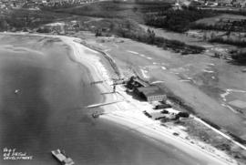
Fraserview Golf Course
Fraserview golf course

Fraserview golf course
Fraserview Golf Course, Field House

Fraserview Golf Course, Field House
Golf - B.C. Amateur Championships

Historical : original appearance, Shaughnessy golf course

Historical : original site, Shaughnessy Golf Course
Historical : Shaughnessy golf course

Jericho Golf and Country Club
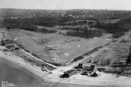
![[Land being cleared for the Shaughnessy Heights Golf Club]](/uploads/r/null/c/f/cfd21ea2d3777879cf1f21ddde4d3f72ea9c19e0afad7558b39aedab6547dce0/6d3cf00d-0514-4067-bec7-eb305ec3696a-A25885_142.jpg)
[Land being cleared for the Shaughnessy Heights Golf Club]
Langara Golf Course

Langara Golf Course - Field House, front

Langara Golf Course - Field House, side
![[Man playing golf at Shaughnessy Golf Links]](/uploads/r/null/e/5/e5ab27386d2175192396454ba885477ce6aac5417744ba6e9f809919ef90aac7/a116d4cf-9121-4c48-ae68-2281ac98f3d3-A09376_142.jpg)
[Man playing golf at Shaughnessy Golf Links]
![Marine [Drive] Golf and Country Club](/uploads/r/null/2/2/22dd7d67e047d71c0f207458004881b05bf22a940c8bddaaa2db847cb332fbf4/a7febf44-080b-476f-8dcf-0db0ea97ca43-A17196_142.jpg)
Marine [Drive] Golf and Country Club
![[Men playing golf at Hastings Park Golf Links]](/uploads/r/null/2/9/29f921cc89582ad32eeff34e7139a01bf47fc0d0310f8b3b318a8b2d8be333cc/d8f4617e-f907-4d71-8fa6-8cde4c7a0280-A09372_142.jpg)
[Men playing golf at Hastings Park Golf Links]
![[Men playing golf at Hastings Park Golf Links]](/uploads/r/null/6/4/648ace08b5e7df9132ba62a483dd79429e3d1d6f7a4feb64ad528ae63e6e3ad6/6faf8004-ffdc-43ce-a7bf-3d4063400c81-A09371_142.jpg)
[Men playing golf at Hastings Park Golf Links]
![[Men playing golf at Shaughnessy Golf Links]](/uploads/r/null/b/1/b11ebd4b18296c330355054fb770add8467e2b8618c639ad27a1394cbbbcf6d7/ab803656-a105-4582-a4e0-5121501c862d-A09375_142.jpg)
[Men playing golf at Shaughnessy Golf Links]
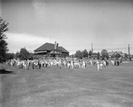
![Park tour, opening [of] Q.E. [Queen Elizabeth] Golf Course](/uploads/r/null/9/b/0/9b03903c0ebb9e780c8cd7c58f301b8aa5779b09c280a237f3449b86ff8e2dc2/0bb3eb60-3325-4ebf-8437-c5c231cc993a-CVA289-161_142.jpg)
Park tour, opening [of] Q.E. [Queen Elizabeth] Golf Course
![Park tour, Q.E. [Queen Elizabeth] Golf Course, first tee](/uploads/r/null/8/0/e/80e8d33d2645f41523fe8323b58c9b25b223a861a922b4ffae5dfd3ac40100ab/cdb524b6-3fd1-4bb4-8f7c-6d3ac58314b6-CVA289-169_142.jpg)
Park tour, Q.E. [Queen Elizabeth] Golf Course, first tee
![Park tour, Q.E. [Queen Elizabeth] Golf Course, Rathie tees off](/uploads/r/null/8/5/a/85a5339734dd25c50dbd465a7cfd9712a78cb9c082b4a3f6bcd8579937b2103b/201cb627-30de-444c-af30-5a7acfaf28ad-CVA289-162_142.jpg)
Park tour, Q.E. [Queen Elizabeth] Golf Course, Rathie tees off
![Park tour, Q.E. [Queen Elizabeth] Golf Course, the first ball](/uploads/r/null/c/5/2/c5232d7cb6a179549691c53a6d57cdb149c692be5d65a74aa5070f5a86b82c15/e21407c2-255e-4ef5-92da-df56d829cc99-CVA289-168_142.jpg)
Park tour, Q.E. [Queen Elizabeth] Golf Course, the first ball
![Park tour, Q.E. [Queen Elizabeth] Golf Course, Wainburn tees off](/uploads/r/null/3/1/6/31684c8eff04796ee32b4683e4de074e681a0ce6d2c96bdb62331b8c9d6e8bc3/f198013b-364f-4855-be3b-83f4c4ae71ee-CVA289-163_142.jpg)
Park tour, Q.E. [Queen Elizabeth] Golf Course, Wainburn tees off
![Park tour, Rathie opening Q.E. [Queen Elizabeth] Golf Course](/uploads/r/null/1/c/8/1c888f5633fda80137cbbe8d41214d8c3652c0b661778542d13800b6a6444826/778abd4f-e53e-4bb6-a4b0-d9a49b0d1706-CVA289-164_142.jpg)
Park tour, Rathie opening Q.E. [Queen Elizabeth] Golf Course
![Park tour, Rathie opening Q.E. [Queen Elizabeth] Golf Course](/uploads/r/null/5/0/7/507b65bb2c74e4090f9019b641f0a106def4dbcf372873456ae18765557d0f0b/e1ceb1e9-1e6a-4093-8a54-e959a6139e72-CVA289-165_142.jpg)
Park tour, Rathie opening Q.E. [Queen Elizabeth] Golf Course

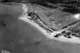
Pee Wee Golf Course - Cardero Street and Georgia Street
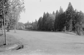
![[Shaughnessy Golf Links fairway]](/uploads/r/null/2/5/2542348b5679ef2560e33894313187273ac862e96ed53528df5161d5e46a7fc7/148fd6b7-c64b-4d02-8556-9706faa6308d-A09377_142.jpg)
[Shaughnessy Golf Links fairway]

Sheet 11 : Cambie Street to St. George Street and Forty-seventh Avenue to Fifty-eighth Avenue

Sheet 11 : Cambie Street to St. George Street and Forty-seventh Avenue to Fifty-eighth Avenue

Sheet 17 : Argyle Street to Vivian Street and Sixty-second Avenue to Kent Street

Sheet 17 : Argyle Street to Vivian Street and Sixty-second Avenue to Kent Street

Sheet 18 : Vivian Street to Boundary Road and Sixty-fifth Avenue to Fraser River
[Sheet 66 : Musqueam Indian Reserve to Balaclava Street and Forty-ninth Avenue to Forty-first Avenue]

Sheet 66 : Musqueam Indian Reserve to Balaclava Street and Forty-ninth Avenue to Forty-first Avenue