![[Woman playing golf at Shaughnessy Golf Links]](/uploads/r/null/5/2/52b65cae32419a06b2aba969fbed264594e7bbeed9124465a60b584c831621c1/ee72f45e-c7ad-4a47-8d13-55633915a82f-A09373_142.jpg)
[Woman playing golf at Shaughnessy Golf Links]
![[Woman playing golf at Shaughnessy Golf Links]](/uploads/r/null/b/6/b63922f1d6d5bcc74b9af9bd157207382cb6c45f937aef9c6e44d6d00646df26/7fe95cf0-004e-4707-b720-a4c9d9673aab-A09374_142.jpg)
[Woman playing golf at Shaughnessy Golf Links]
![[View of twelfth fairway at Jericho Country Club]](/uploads/r/null/3/b/3b8ae3229c028aa88763cf3d0ff86254e0ef0853ab07d82f1e7edd6e8a0d84fd/62c603b9-0509-4aa8-86c7-8adda931ffe7-A25809_142.jpg)
[View of twelfth fairway at Jericho Country Club]
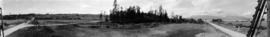
![[View of the McCleery Golf Course]](/uploads/r/null/9/6/96df14f046a14a4e0224f3ea2b5453721a5bdc174c9b462be541a7c387f3e219/f1d2ba74-0f49-458e-ae1d-852090b479ce-A62553_142.jpg)
[View of the McCleery Golf Course]
![[View of the McCleery Golf Course]](/uploads/r/null/b/8/b81c4624512fd3c2615be45e96a60733dda76e878df09ad1afd308f0dfa3f9e7/7ebc6f76-e7a4-465d-a57c-6bd3b7553f59-A62551_142.jpg)
[View of the McCleery Golf Course]
![[View of the fourth green at Jericho Country Club]](/uploads/r/null/3/8/38b9bf350dcbadfbea27cc83f81d07bd4e60ae6477733a440f028f4fb1222296/81464b53-e592-4f24-8133-afa598d68e27-A25808_142.jpg)
[View of the fourth green at Jericho Country Club]
[View of Imperial Street, Jericho Country Club golf course with Jericho beach and the North Shore in the background.]
![[View of Granville Street and 37th from the 5200 block, Shaughnessy]](/uploads/r/null/4/7/474b6dcf8ef35087ef9b76000cfbe43c23bd03fbd291f22d3ab8f42be1c46994/34a9c2f5-a821-4376-85e7-c727125ccbbb-A63184_142.jpg)
[View of Granville Street and 37th from the 5200 block, Shaughnessy]

Trees on Fraserview Golf Course

Stream on Langara Golf Course

Stanley Park Golf Course

Sketch plan showing suggested area for municipal golf links, Vancouver, B.C.

Sheet W : Fraser River to French Street and Fifty-ninth Avenue to Seventy-first Avenue

Sheet W : Fraser River to French Street and Fifty-ninth Avenue to Seventy-first Avenue

Sheet W : Fraser River to French Street and Fifty-ninth Avenue to Seventy-first Avenue

Sheet U : Churchill Street to Cambie Street and Forty-ninth Avenue to Park Drive

Sheet U : Churchill Street to Cambie Street and Forty-ninth Avenue to Park Drive

Sheet T : Marine Crescent to Granville Street and Forty-ninth Avenue to Sixty-first Avenue

Sheet T : Larch Street to Granville Street and Forty-ninth Avenue to Sixty-first Avenue

Sheet S.V. 4 : Ash Street to St. George Street and Fifty-first Avenue to Sixty-third Avenue

Sheet S.V. 3 : Cambie Street to Prince Edward Street and Thirty-ninth Avenue to Fiftieth Avenue

Sheet S.V. 17 : Jellicoe Street to Boundary Road and Sixty-third Avenue to Fraser River

Sheet S.V. 16 : Dawson Street to Boundary Road and Fiftieth Avenue to Sixty-third Avenue

Sheet S.V. 12 : Fleming Street to Raleigh Street and Forty-eighth Avenue to Newport Avenue

Sheet S : Musqueam Reserve to Macdonald Street and Forty-ninth Avenue to Fraser River

Sheet S : Musqueam Reserve to Macdonald Street and Forty-ninth Avenue to Fraser River

Sheet Q : Churchill Street to Cambie Street and Thirty-eighth Street to Forty-ninth Avenue

Sheet Q : Churchill Street to Cambie Street and Thirty-eighth Street to Forty-ninth Avenue

Sheet P : Trafalgar Street to Granville Street and Thirty-ninth Avenue to Forty-ninth Street

Sheet O : Holland Street to Elm Street and Thirty-eighth Avenue to Forty-ninth Avenue

Sheet O : Holland Street to Elm Street and Thirty-eighth Avenue to Forty-ninth Avenue

Sheet M : Granville Street to South Cambie Street and Twenty-seventh Avenue to Thirty-eighth Avenue

Sheet M : Granville Street to Kersland Drive and Twenty-seventh Avenue to Thirty-eighth Avenue

Sheet M : Granville Street to Kersland Drive and Twenty-seventh Avenue to Thirty-eighth Avenue

Sheet L : Trafalgar Street to Granville Street and Nanton Avenue to Thirty-eighth Avenue

Sheet L : Trafalgar Street to Granville Street and Nanton Avenue to Thirty-eighth Avenue

Sheet L : Trafalgar Street to Granville Street and Nanton Avenue to Thirty-eighth Avenue

Sheet H : Alexandra Street to Cambie Street and Fifteenth Avenue to Twenty-seventh Avenue

Sheet G : Trafalgar Street to Granville Street and Sixteenth Avenue to Nanton Avenue

Sheet G : Trafalgar Street to Granville Street and Sixteenth Avenue to Nanton Avenue

Sheet G : Trafalgar Street to Granville Street and Sixteenth Avenue to Nanton Avenue

Sheet D : Imperial Street to Trutch Street and Fourth Avenue to Sixteenth Avenue

Sheet D : Imperial Street to Trutch Street and Fourth Avenue to Sixteenth Avenue
![[Sheet 88 : Macdonald Street to Angus Drive and Edgington Avenue to Fifty-seventh Avenue]](/uploads/r/null/5/9/595b991e091f624b5f74507db063dddb150624fbef03fe1d577f8d7a32bb9088/8afa1350-f31b-43bd-a14f-0ea9082c21fe-MAP339_142.jpg)
[Sheet 88 : Macdonald Street to Angus Drive and Edgington Avenue to Fifty-seventh Avenue]

Sheet 88 : Macdonald Street to Angus Drive and Edgington Avenue to Fifty-seventh Avenue

Sheet 79 : Gladstone Street to Kerr Street and North Arm of Fraser River to Bobolink Avenue
![[Sheet 79 : Gladstone Street to Kerr Street and North Arm of Fraser River to Bobolink Avenue]](/uploads/r/null/7/9/79214408afd85e4ab6ccc7eec43ecc85caf5ce5dedb9cfeb219866aa0091a733/7696de5a-3bba-4c2d-bc6c-83bf14bcf845-MAP339_142.jpg)
[Sheet 79 : Gladstone Street to Kerr Street and North Arm of Fraser River to Bobolink Avenue]
![[Sheet 75 : Nanaimo Street to Kerr Street and Bobolink Avenue to Forty-ninth Avenue]](/uploads/r/null/d/1/d14981939464fabe5e1b9488ecd26d62b3e16b1f4d1b8e00ece1bac6fa0dbdfa/a8e1d890-9726-473c-8f49-69d918d62d56-MAP339_142.jpg)
[Sheet 75 : Nanaimo Street to Kerr Street and Bobolink Avenue to Forty-ninth Avenue]

Sheet 75 : Nanaimo Street to Kerr Street and Bobolink Avenue to Forty-ninth Avenue

Sheet 70 : Macdonald Street to Cypress Street and Fifty-seventh Avenue to Forty-ninth Avenue