
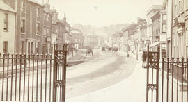
Fort Street - Victoria
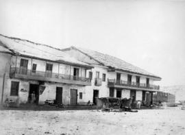
Square at Coquimbo
![[Donkey and cart in front of building at] Coquimbo](/uploads/r/null/b/3/b379c73b56dc694447f4155976267de2511c2fc932567f2af67bfead67d27eaa/ed960235-4b6d-4089-8f79-7453fd18095e-A23126_142.jpg)
[Donkey and cart in front of building at] Coquimbo
![[Waterfront view of] Esquimalt Village](/images/generic-icons/image.png)
[Waterfront view of] Esquimalt Village
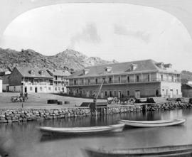
Road Leading to Dockyard - Esquimalt
![Thetis Island [in] Esquimalt [Harbour]](/uploads/r/null/4/4/4489a3d594f5cfe6745f5e2a5de234cc433a82fe9ed8a0be43a4418899df2b7e/5297edf5-fd8d-49ef-a6be-ccdba53b452b-A22926_142.jpg)
Thetis Island [in] Esquimalt [Harbour]

Ghant from which the survivors in the entrenchment were embarking when fired upon by Nana's people and brought back to Cawnpore

Government Street - Victoria

Village of Esquimalt
![[View of buildings at] Coquimbo](/uploads/r/null/1/8/182ef865443e66dfbf94d83977b0aeb2d617051537fdaf9a8088e60ba7a1e391/9951bd01-0e43-470a-a01a-ad823f456da3-A23127_142.jpg)
[View of buildings at] Coquimbo

14 Mile House [showing freight teams passing tavern 15 miles above Yale
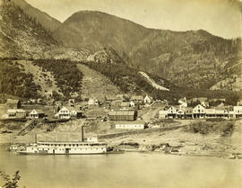
Yale from the gold field

Boston Bar 25 miles above Yale
![[Covered wagons being driven through Boston Bar]](/uploads/r/null/2/7/2757509c38f84a9ddd19e5303ed1d386c35620aac27004148c04f7724ee85944/b70f8e2c-e398-45ff-8666-7c062f9fd5a9-A33837_142.jpg)
[Covered wagons being driven through Boston Bar]
![Yale [showing] gold field opposite [across Fraser River]](/uploads/r/null/c/3/c3b5a65995f782ba54ae03df2bc55bc472f06f2cd8d25cf526390df9e47e33c8/de7cdbe7-5ba9-447a-a911-7c4a52876faf-A19666_142.jpg)
Yale [showing] gold field opposite [across Fraser River]

Place Victoria Valparaiso

Square at Lima - South America 1867

Nanaimo
Esquimalt

Victoria

Esquimalt
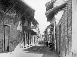
Street at Payta
![[Buildings and tethered donkeys at Payta]](/uploads/r/null/5/a/5a1c9fa1bb8e1ac8795c8eeefb38112289d791b81c9674d7977ae62de4581306/feb27262-513a-4641-a35b-1e6f4303e9b3-A23094_142.jpg)
[Buildings and tethered donkeys at Payta]
Barkerville

Square at Payta
Square at Payta

Boothroyd's - 36 miles above Yale
![[View of Victoria from across James Bay]](/uploads/r/null/b/5/b560b9afac0b4e54d5bf5846f8394bb06ea5fc3d21452b0aef8e3a80cc943bb8/25806ff1-9cb2-4a09-a2c7-478d8de095d7-A33958_142.jpg)
[View of Victoria from across James Bay]
![[Unidentified lake and lock]](/uploads/r/null/7/f/7fd8e12f3d5c263cbb42b3d3ec0197181a5e50fab808ca45cfe220420a0027a0/24e461b1-9eff-43a4-833b-94a9008922ab-A19737_142.jpg)
[Unidentified lake and lock]
![[Spences Bridge (Cook's Ferry)]](/uploads/r/null/1/f/1f87fae981e024c2c4c8276687c40cae00752c4549eee6ba87d8ccd412b0336b/aa5b28ae-47a4-4eca-b9ab-cff679beb17f-A33600_142.jpg)
[Spences Bridge (Cook's Ferry)]
![Percy Powys [near] Henley Bridge](/uploads/r/null/f/8/f87ecc453f39389d3425d37c13f0d6fe623e9bc99440c07166848b0fbf6c8505/22114b74-7ac0-4ec1-955d-417b3871bfe4-A19720_142.jpg)
Percy Powys [near] Henley Bridge

(Main St.) West Westminster Avenue, Vancouver
Hart Street and Market Place
![[Unidentified building]](/uploads/r/null/4/2/42fac4d8e9c308cf77260a2def410a636a68c293ff1b997bb39607e5ba0e26df/8fc3c361-efe2-4b98-83ff-53fe5fce9675-A19743_142.jpg)
[Unidentified building]
![[Port Moody]](/uploads/r/null/a/8/a8c2664076fa4f8ab2a409e5240e4c3740d6914e3a818ac8eac7fe948c783c78/5ef8253e-c9e1-4601-a3c7-4334aee88684-A26772_142.jpg)
[Port Moody]

New Brighton where Alberta Wheat Pool now stands
![[Waterfront view of Port Arthur, Ontario]](/uploads/r/null/9/b/9b1fcdbaf9b6135c649058f37fa4212a0950ee9d4906ad3c8b4a87f55aeb427c/ffdba193-eb1a-4dae-8640-b543b602a19f-A26922_142.jpg)
[Waterfront view of Port Arthur, Ontario]
![[Wah Chong family outside laundry business on Water Street]](/uploads/r/null/f/3/f37dc7524202f3f591ad0297fe7c5ecbbab45b77708d819071c6ea427a74b69e/6f0fc4e5-81eb-4022-b24b-924520944387-A36870_142.jpg)
[Wah Chong family outside laundry business on Water Street]

Town of Lytton From Railway Looking North
![[View of Moodyville from the water]](/uploads/r/null/2/4/24a8574f406354a0e5c7b8622d69289f5b12dfc4a3f94d025c797d57b16511de/60117dcc-a5ea-4efe-938a-161eaa5197d1-A26836_142.jpg)
[View of Moodyville from the water]
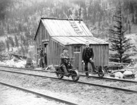
Telegraph station
![[Pinchbeck and Lyon flour mill]](/uploads/r/null/3/b/3be257381895d508fc811aec536665f2a329474ab4646d87657f2fed8d6e213d/465baef3-8dd6-43d7-a5a0-df9834a09289-A33100_142.jpg)
[Pinchbeck and Lyon flour mill]
![[View from the Hotel Vancouver]](/uploads/r/null/5/f/5fd30a3fc14063f0dbb640587b3558030cbb3634316d54c57ae1f0125342b807/2e027352-524f-44a4-ad9f-7ddeb3cca11e-A01983_142.jpg)
[View from the Hotel Vancouver]
![[View of Granville]](/uploads/r/null/e/c/ec241f1f7d3198fa60f1f3379ed576b8db1e05b54c6aa78fc33725085908a372/e684b04b-1d25-443e-8e07-09387b5f4861-A25892_142.jpg)
[View of Granville]
![[Spences Bridge]](/uploads/r/null/1/2/12d6cf4fc043911bb5bfefbb066d9923d9a35c4baa8a64a47e1b676cf75f39cb/54798946-2f64-4712-a1d4-15dbcc417df3-A33617_142.jpg)
[Spences Bridge]

Lytton, B.C.

Real estate sales boomed from location near Main St. between Hastings and Cordova
![[Vancouver waterfront] before the fire [of 1886]](/uploads/r/null/c/3/c3352d4e081baca4f146ed2adc7664eeafac7ea99bd81cb5c48945f20e2c48c6/dda504a5-1c66-40f9-bc43-cf2b5c69b082-A04843_142.jpg)
[Vancouver waterfront] before the fire [of 1886]

[Exterior of A.W. Ross Real Estate and E.C. Coulding Law Office building on Hastings between Homer and Hamilton Streets]
![Stamp Mill [on] Douglas Island as seen from the mine](/uploads/r/null/1/a/1ad366de71d953fbfe9e9691a073f42648353fe657e5138a26ba339840c6ad3e/1469d9c3-0a78-4afd-82d3-3d94842e0078-A19708_142.jpg)
Stamp Mill [on] Douglas Island as seen from the mine