
Sheet 18 : Trutch Street to Maple Street and English Bay to Third Avenue
- COV-S303-MAP 343-: MAP 343.20
- Item
- [ca. 1925], with revisions to [ca. 1945]
Part of City of Vancouver fonds
Item is a section showing Trutch Street to Maple Street and English Bay to Third Avenue. Includes streets, roads, blocks, lots, legal descriptions, parks and crown grants. Map is hand coloured to show tax sale property for sale, property with no water, street widening and drainage, replotting, reserved land for schools, reserved land for parks, sundry land, capital assets not including schools and parks, schools, and parks.
Vancouver (B.C.). Office of the City Engineer


![[Dick Burgess, driver, Nemo Layfield, tiller, on aerial truck at Firehall No. 1]](/uploads/r/null/5/3/7/53716591402a12ce891715e5a4a7d5f4434c640c1302912053ef25d630290b44/e508b1ef-39ee-49c9-a001-2e75ce893a4e-CVA354-013_142.jpg)
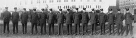
![[Firefighters standing on balcony of No. 4 Firehall at 10th Avenue and Granville Street]](/uploads/r/null/2/f/d/2fd4cf1cbacbf21ea2370397ed595de7e8ff2fb8fcf2b4387ef25efc8ace3d5a/394bd92d-3699-4aec-9f06-8d37b277a757-CVA354-022_142.jpg)
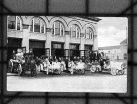
![[1912 American-La France Hose Chemical wagon and firefighters in front of Point Grey Firehall No. 1]](/uploads/r/null/5/9/0/590a2f772f6506d4206377625b9c2c493282a86428ee8591c5a88e52f5c593d8/0222654e-7112-41a6-8475-f12b5d48c0b4-CVA354-034_142.jpg)

![[Two firemen in Point Grey Fire Department Chief's automobile]](/uploads/r/null/e/b/c/ebc94a44006330a7417e906a39d686ad1bf925c9b3caeeec600f4fd9a3df3683/096cdfe2-9828-4c08-a730-5decdb017472-CVA354-039_142.jpg)
![[Members of South Vancouver Fire Department aboard Hose Chemical truck on street]](/uploads/r/null/2/0/f/20fece789651c38866327ed56433cbfb3f7460b0a11daef5a6e79a17deca8175/0e0b9130-c685-4586-b7e6-95e1411df687-CVA354-041_142.jpg)
![[Firefighters and motorized equipment in front of Firehall No. 2, 754 Seymour Street]](/uploads/r/null/1/a/2/1a2f1373f1d648856294c4009aca38f93d121927679c379a3ab4dd4db0fd8128/e7169b57-02b8-4cc5-a5d8-122e1c212954-CVA354-043_142.jpg)
![[Studio portrait of firefighter Alex Alexander]](/uploads/r/null/e/6/2/e62ae1b4640ad564410c78d02c930760fe38b3fcf766277e62c2f1b77937b1a6/701b8005-a725-451c-b50e-08cfb6f3971a-CVA354-045_142.jpg)
![[Point Grey Fire Department firefighters and motorized equipment in front of firehall]](/uploads/r/null/1/1/3/113fb9c321052a570412e3113c5ab221aa163dae5546d28d3496f4b0edef26df/e9cbb090-82c4-4973-a9ae-bb2ef6530c32-CVA354-046_142.jpg)
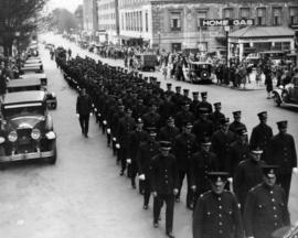
![[Gathering of fire engines to show "Fully Motorized" occasion at C.P.R. freight yards]](/uploads/r/null/4/6/4/464e3333148bebd4439aa317794f2892018b4cdc4c4f2c3e8cfed544422a76d1/ac7aecd4-f952-4786-9697-0f24efacfc7c-CVA354-049_142.jpg)
![[View of aftermath of fire at Coughlin Shipyards - Fmn. (fireman) Cameron killed]](/uploads/r/null/0/9/4/09432532898fda03f4d03a2915beec43a56c9ffe28f335bee8a3b5e1edfbfa8a/19792784-df36-4eeb-abce-7fa1ec269cb2-CVA354-052_142.jpg)
![[Group portrait for opening of South Vancouver Firehall No. 3 for opening]](/uploads/r/null/0/3/b/03be9559d102890d505b0bba59df610904391233bf03fde80beefb2ddddb1665/2d33bb93-0663-4c85-906e-0ca20d50fd56-CVA354-059_142.jpg)
![[Group portrait of Vancouver Firemen's Football Club in front of bleachers]](/uploads/r/null/1/f/f/1ff9b85dd289b443813c5f5dd83e945ed374bdb8b68debcd8086c9e0fef57bdf/d39b7556-2618-4ffa-9eb8-3f72aba7e16c-CVA354-060_142.jpg)
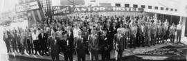
![[Group portrait of delegates and guests to Firemen's convention, Victoria, B.C.]](/uploads/r/null/f/d/f/fdf1e39e20db8386972359a7859ef1a8c73e9e03de56282c147955add0ef6d26/ec0cbe14-9e5b-4881-b498-cd723f13b279-CVA354-064_142.jpg)
![[Exterior portrait of South Vancouver Fire Department members assembled with equipment]](/uploads/r/null/1/2/2/1226f38dfc38509f585417a7ffa8046a6a72e1c419f007b8a4eebd7f139e2fd5/a169d84a-4713-46b6-9a6f-8596faab8b3a-CVA354-069_142.jpg)
![[Group portrait of Firehall No. 2 firefighters in uniform]](/uploads/r/null/e/5/1/e515eb838de5909dfd08c58c66b76957831eb9e0b34ad99b70480420033dbe08/4794eb5a-3e06-44e7-b7e9-d65f03972789-CVA354-074_142.jpg)
![Chief F. Raymur P.G.F.D. [Point Grey Fire Department]](/uploads/r/null/6/3/b/63ba6cef1c6f6d732c1c7426309d45302294f7987fbf02f0c5011020e4eaa265/50a1ac42-5d80-4e66-bf39-b17a3a6aaeb2-CVA354-081_142.jpg)
![[Firefighter "Red" Creelman cooking at stove at Firehall No. 2]](/uploads/r/null/9/c/e/9cefa2511de70b8c1030238767cf08d4c4d31db839bff5a55f9bb05dc70dd0a9/523038c3-ace5-4104-b096-999639d33bad-CVA354-100_142.jpg)
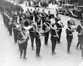
![[Group portrait of Firemen's Band on steps of Vancouver Court House]](/uploads/r/null/6/7/1/671ad823231c96cc5d64acf1461780da510a44b5779df01a4f7d6f2afba9aee6/28cbea32-cd96-49d3-8b15-a1440201704f-CVA354-101_142.jpg)
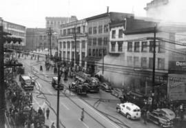
![[View of Canadian Pacific Railway Pier D on fire]](/uploads/r/null/9/4/7/947a23d02f7e0b571dc3ea2c42c87f331257cb8e07a77cd2fd080ee000a32c49/43728ece-6a42-442b-8400-3b359d07fb59-CVA354-104_142.jpg)
![[View of Canadian Pacific Railway Pier D on fire and two fireboats working on the water]](/uploads/r/null/1/a/5/1a5caaed72c26733bb244d7b7cef4dc70a5c4b6f8798bf06446c3833ce46a408/03274c80-6414-44a9-ba31-c04b2ddcfe2a-CVA354-105_142.jpg)

![[View of fire damage to the Canadian Pacific Railway Pier D]](/uploads/r/null/6/3/5/635d13e935d76330673b5019d208298a6ee6d3a5b8b171b52650a641e8c0c6a2/c79e795f-faab-453d-abbc-cf7a83cde71e-CVA354-116_142.jpg)