![Sheet 62 [NW] : Brunette River to Tenth Avenue to Eighth Street to Fraser River](/uploads/r/null/8/c/0/8c00b096f6257381d8b28e6fe276a91bec30a8f112a0ac0c770cb6fc7550fb89/8a082b06-1a35-4b7d-a7d3-53c33798cd56-LEG1831_142.jpg)
Sheet 62 [NW] : Brunette River to Tenth Avenue to Eighth Street to Fraser River
- AM1594-: LEG1831-: LEG1831.59
- Item
- 1912
Part of City of Vancouver Archives technical and cartographic drawing collection
Sheet 62 [NW] : Brunette River to Tenth Avenue to Eighth Street to Fraser River
Part of City of Vancouver Archives technical and cartographic drawing collection

Sheet 4 N.V. William Street to Twenty-eighth Street to Chesterfield Avenue to Seventeenth Street
Part of City of Vancouver Archives technical and cartographic drawing collection
Item is a section which has been annotated in pencil to show revisions to the street grid to connect Twenty-fifth Street to Grand Boulevard.
![Sheet 9 N.V. : Seymour River to Lynn Canyon to Hoskins Road to [Keith Road?]](/uploads/r/null/3/7/5/375911fd91c57f28aaa91e483da08e145effcd26c69d693ebf72f1bf590e9442/c9afad59-d672-4c8e-96b7-0bdd968fb8fc-LEG1831_142.jpg)
Sheet 9 N.V. : Seymour River to Lynn Canyon to Hoskins Road to [Keith Road?]
Part of City of Vancouver Archives technical and cartographic drawing collection

Sheet 11 N.V. : Lower Seymour Creek
Part of City of Vancouver Archives technical and cartographic drawing collection
Item is a section depicting the area east of the Seymour River and approximtely south of the current Mt. Seymour Parkway to the Burrard Inlet shoreline.

Distribution system of waterworks, City of New Westminster, British Columbia
Part of City of Vancouver Archives technical and cartographic drawing collection
Item is a published map of the City of New Westminster which has been annotated to depict a planned sewer system.
Hill, Albert J.
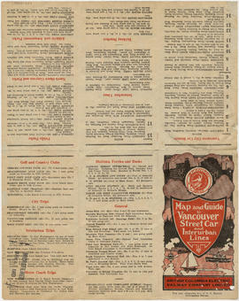
Map and guide to Vancouver street car and interurban lines
Part of City of Vancouver Archives technical and cartographic drawing collection
Part consists of the front page of a brochure, listing the various streetcar and interurban rail lines, and routes to points of interest in Vancouver.

Vancouver city and suburban lines
Part of City of Vancouver Archives technical and cartographic drawing collection
Part consists of a map of streetcar and interurban rail lines in Vancouver.
![Hastings Townsite [Boundary Road to 5th Avenue to Kamloops Street (?) to 33rd Avenue]](/uploads/r/null/7/f/0/7f0fe2a27b9af4f20ad7837792af3bbb3aa93c3487024e69b14fa38144134f19/8e7a0e66-c6cc-40ca-bbac-4ea73db77437-LEG1800_142.jpg)
Hastings Townsite [Boundary Road to 5th Avenue to Kamloops Street (?) to 33rd Avenue]
Part of City of Vancouver Archives technical and cartographic drawing collection
Part consists of a portion of the map, depicting the area approximately bounded by Boundary Road, 5th Avenue, Kamloops Street (?) and 33rd Avenue.

Map and guide to Vancouver street car and interurban lines
Part of City of Vancouver Archives technical and cartographic drawing collection
Part consists of the front page of a brochure, listing the various streetcar and interurban rail lines, and routes to points of interest in Vancouver.

Reference schedule AA - Floodplan map
Part of City of Vancouver Archives technical and cartographic drawing collection
Item is a section of a map that includes four sections. This section is the north-western quadrant, depicting the western half of greater Vancouver. The map shows physical, economic and transportation features.
Lower Mainland Regional Planning Board

Part of City of Vancouver Archives technical and cartographic drawing collection
Part contains street maps of the University Endowment Lands, Surrey, Maillardville, Lulu Island and Sea Island, tourist information about Vancouver, and text advertising the products and services of the Dominion Map and Blueprint Company.

Map of downtown section of Vancouver ; Diagram of New Westminster, B.C., downtown section
Part of City of Vancouver Archives technical and cartographic drawing collection
Part contains road maps of downtown Vancouver and New Westminster, and textual information for tourists and motorists.

Automobile road map of Greater Vancouver and environs : map cover
Part of City of Vancouver Archives technical and cartographic drawing collection
Map cover includes advertisements for Eng Chow Company and Happyland.

Part of City of Vancouver Archives technical and cartographic drawing collection

Part of City of Vancouver Archives technical and cartographic drawing collection

Schedule "A" : Polling districts : City of Vancouver
Part of City of Vancouver Archives technical and cartographic drawing collection
Item is a map showing polling districts in Vancouver. Three smaller maps show the areas around Point Grey Road and Collingwood Street, 30th Avenue and Trafalgar Street, and 66th Avenue and Ash Street in greater detail. Two districts are marked in red, but the meaning of these annotations is unknown.

Part of City of Vancouver Archives technical and cartographic drawing collection
Item is a map of Greater Vancouver annotated to show ward boundaries. Base map shows streets, some district lot numbers, and distances from City Hall. A smaller detail map shows Granville Island.
![Vancouver, B.C., the Pacific coast terminus of the C.P.R. [Canadian Pacific Railway]](/uploads/r/null/8/3/f/83fcf65f0d66d64e6357d0d647e0ea6e2fa4aae4c3d1919f952d7725b4299cda/623e750c-fbab-43b7-a496-d20b384baeb6-LEG1321_142.jpg)
Vancouver, B.C., the Pacific coast terminus of the C.P.R. [Canadian Pacific Railway]
Part of City of Vancouver Archives technical and cartographic drawing collection
Part contains text and engravings describing Vancouver's climate, resources, industries, and buildings. Cover page is stamped "Arthur McMullen."

University Endowment Lands : plan of units nos. 1 and 2
Part of City of Vancouver Archives technical and cartographic drawing collection
Item is a map showing streets, land subdivision, properties disposed of, and buildings in the University Endowment Lands north of University Boulevard. Telephone numbers have been changed, issuing date added, and additional blocks filled in by hand, likely by J.S. Matthews.

Hastings Townsite : Renfrew Street to Rupert Street and 5th Avenue to 13th Avenue
Part of City of Vancouver Archives technical and cartographic drawing collection
Part is a sheet of a sectional map of Hastings Townsite showing streets, railways, legal addresses, some lot sizes, and municipal boundaries. Item has been annotated with information regarding property ownership, including identification of properties included in a 1919 tax sale, and various symbols of unspecified meaning.

Hastings Townsite : Rupert Street to Boundary Road and 5th Avenue to 13th Avenue
Part of City of Vancouver Archives technical and cartographic drawing collection
Part is a sheet of a sectional map of Hastings Townsite showing streets, railways, legal addresses, some lot sizes, and municipal boundaries. Item has been annotated with information regarding property ownership, including identification of properties included in a 1919 tax sale, and various symbols of unspecified meaning.

Part of City of Vancouver Archives technical and cartographic drawing collection
Part is a sheet of a sectional map of Hastings Townsite showing streets, railways, legal addresses, some lot sizes, and municipal boundaries. Item has been annotated with information regarding property ownership and various symbols of unspecified meaning.

Part of City of Vancouver Archives technical and cartographic drawing collection
Item is a map showing topography, roads, trails, railways, bridges, boundaries, reserves, power lines, telephone lines, triangulation stations, camera stations, bench marks, houses, barns, mills, factories, schools, churches, post offices, telephone exchanges, mines and geographic features in the Pitt Meadows area and extending south through Cloverdale and Langley to the United States border. A small index map shows the area covered by the primary map in relation to other maps in the series.

Part of City of Vancouver Archives technical and cartographic drawing collection
Item is a map showing topography, roads, trails, railways, bridges, boundaries, reserves, power lines, telephone lines, triangulation stations, camera stations, bench marks, houses, barns, mills, factories, schools, churches, post offices, telephone exchanges, mines and geographic features in the Pitt Lake area, including Coquitlam Mountain, Mount Blanshard, and Siwash Island. A small index map shows the area covered by the primary map in relation to other maps in the series.

A preliminary proposal for development of Jericho Park
Part of City of Vancouver Archives technical and cartographic drawing collection
Item shows proposed uses for Jericho Park.

Map from the Pacific Ocean across the Rocky Mountain zone
Part of City of Vancouver Archives technical and cartographic drawing collection
Item is a map depicting rivers, lakes, towns, and proposed railway routes.
![Chart of Nepigon [Nipigon] Bay. Lake Superior](/uploads/r/null/e/6/0/e6083525f33c7a6d0dd05f840915433768b0cfaed2c5b564153e3bfb5830f77e/8dd4e8d6-c36f-488f-a1bb-7aea7e098200-LEG1153_142.jpg)
Chart of Nepigon [Nipigon] Bay. Lake Superior
Part of City of Vancouver Archives technical and cartographic drawing collection
Item is a hydrographic chart depicting steamboat routes, roads, towns, rivers, soundings, and relief hachures on adjacent land areas.
Part of City of Vancouver Archives technical and cartographic drawing collection

Part of City of Vancouver Archives technical and cartographic drawing collection
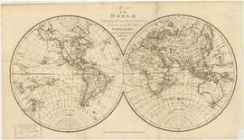
Item is a map showing Canada, Lower Canada, the United States, Florida and western North America. The map depicts physical features, towns, and aboriginal tribes.

Part of City of Vancouver Archives technical and cartographic drawing collection
Part depicts the upper left hand quadrant of the map, and includes a diagram of the solar system, a table of dimensions of bodies in the solar system, a chart of constellations viewable in the northern hemisphere, text on geographical definiations and the cause of the tides, and a map of the northern half of the Americas.
Dunn, Samuel

Part of City of Vancouver Archives technical and cartographic drawing collection
Item is a map depicting the shoreline of Stanley Park and the West End, the low water line and the new channel.
Bayfield and Archibald, Consulting Mechanical Engineers

Part of City of Vancouver Archives technical and cartographic drawing collection
Item is a map depicting the area of the former Department of National Defence site at Kitsilano Point (now part of Vanier Park). The map shows the locations of the various Defence buildings on the site.
Vancouver (B.C.). Office of the City Engineer

Part of City of Vancouver Archives technical and cartographic drawing collection
Item is a modern photocopy of a map showing the southwest portion of British Columbia and the northwest part of Washington State. The map depicts settlements, geographical features, wagon roads, bridle paths and other man-made features. Prepared under the direction of Capt. Persona, R.E. by order of Col. R.C. Moody, R.E.

Part of City of Vancouver Archives technical and cartographic drawing collection
Item is a map depicting the area of the former Department of National Defence site at Kitsilano Point (now part of Vanier Park). The map shows the locations of the various Defence buildings on the site. Annotations show a grid layout imposed on the site.
Vancouver (B.C.). Office of the City Engineer
![Plate 118 [Brunette River to Tenth Avenue to Langley/School/Keary Streets to Brunette Street]](/uploads/r/null/1/2/c/12c40d6d14f873e070ca2b0a5bfe05f2d1b13bcaf1775c8dc357e7ca81a55dda/1f12f0be-27cc-46e2-a722-0a8c209f762c-1972-472_142.jpg)
Plate 118 [Brunette River to Tenth Avenue to Langley/School/Keary Streets to Brunette Street]
Part of City of Vancouver Archives technical and cartographic drawing collection

Plate 125 Queensborough - south-west
Part of City of Vancouver Archives technical and cartographic drawing collection

Plate 128 Queensborough - north-east
Part of City of Vancouver Archives technical and cartographic drawing collection
![Section 2 [Jervis Street to Granville Street]](/uploads/r/null/c/f/5/cf5684518fb1cdac0f2d643c89acc078a47fe51a6a1896caf8fcfaf23999a562/c5097ebd-7d02-4ddb-be5e-d0f2658f2849-1972-581_142.jpg)
Section 2 [Jervis Street to Granville Street]
Part of City of Vancouver Archives technical and cartographic drawing collection
![Section 3 [Granville Street to Abbott Street]](/uploads/r/null/f/7/c/f7c18e536d617ec84d3c777f7d3bc02b98868d606842132c28166caaaa2dac3d/7e715850-e92f-48ba-bbc7-3678c5a832df-1972-581_142.jpg)
Section 3 [Granville Street to Abbott Street]
Part of City of Vancouver Archives technical and cartographic drawing collection
![Section 4 [Abbott Street to Gore Avenue]](/uploads/r/null/d/0/b/d0bdb5bfbb8ea9ebfe40ab12d3166035d9041c0874b44ccbcf0feaf7d343e90d/3d33023b-e416-4a39-b51c-f201b58c1e2c-1972-581_142.jpg)
Section 4 [Abbott Street to Gore Avenue]
Part of City of Vancouver Archives technical and cartographic drawing collection
![Section 6 [Heatley Avenue to Raymur Avenue]](/uploads/r/null/3/a/0/3a00a7d7ff2433b00b59b0d575006a89ff1e36eea4ecb961d585d3702308874e/61c58478-fbdc-4b03-b27d-4c69089913cd-1972-581_142.jpg)
Section 6 [Heatley Avenue to Raymur Avenue]
Part of City of Vancouver Archives technical and cartographic drawing collection
Item is a sheet of a fire insurance plan. The sheet includes undated revisions to include designs for a new pier west of the Great Northern Railway warehouse and pier.

Fraser River - Deas Island sheet
Part of City of Vancouver Archives technical and cartographic drawing collection

Burrard Inlet - Vancouver sheet
Part of City of Vancouver Archives technical and cartographic drawing collection

Burrard Inlet - Dollarton sheet
Part of City of Vancouver Archives technical and cartographic drawing collection

Fraser River - triangulation control
Part of City of Vancouver Archives technical and cartographic drawing collection

Burrard Inlet - triangulation control
Part of City of Vancouver Archives technical and cartographic drawing collection
Part of City of Vancouver Archives technical and cartographic drawing collection
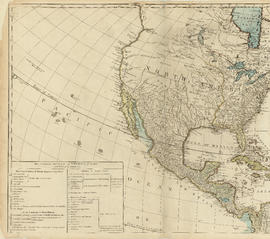
Part is the top left hand quadrant of a map of the Americas, and depicts North America and the north-west portion of South America. The sheet also includes a list of territories and islands in North America and appears to relate to territorial divisions as a result of the Treaty of Paris and the Treaty of Versailles (1783).
![Plate 3 [Seymour Street to Burrard Inlet to Hornby Street to Pender Street]](/uploads/r/null/b/6/e/b6e52f14a0b98be97e608633aaf0e2cdd8d5a51d8772a2b1ef80d1b748c7ebdc/eecaa1fa-a58b-4079-bf99-7f62b81de43f-1972-582_142.jpg)
Plate 3 [Seymour Street to Burrard Inlet to Hornby Street to Pender Street]
Part of City of Vancouver Archives technical and cartographic drawing collection
![Plate 4 [Hamilton & Cambie Streets to CP Railway yards to Seymour Street to Pender Street]](/uploads/r/null/7/e/9/7e931c45a666b558ca27b156ef8b243f5244a2820199fe50e04a7aaed21eeb20/06bd9672-ba7d-4013-aaac-2d7c9d8c5188-1972-582_142.jpg)
Plate 4 [Hamilton & Cambie Streets to CP Railway yards to Seymour Street to Pender Street]
Part of City of Vancouver Archives technical and cartographic drawing collection