
Installation of scoreboard in Pacific Coliseum
- AM281-S8-: CVA 180-5936-: CVA 180-5936.03
- Part
- Dec. 18, 1967
9943 results with digital objects Show results with digital objects
Installation of scoreboard in Pacific Coliseum

Installation of scoreboard in Pacific Coliseum

View of seats from rafters in Pacific Coliseum

Installation of speakers in Pacific Coliseum

Installation of speakers in Pacific Coliseum


Crowd inside Pacific Coliseum during Ice Capades performance

Flying Saucer concession stand on P.N.E. grounds
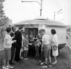
Flying Saucer concession stand on P.N.E. grounds

Woman by main entrance gates to Exhibition Park

Woman by main entrance gates to Exhibition Park

Woman next to P.N.E. B.C. Building


Aerial view of crowd at outdoor concert in Empire Stadium


Aerial view of crowd at outdoor concert in Empire Stadium

Aerial view of crowd at outdoor concert in Empire Stadium

Aerial view of crowd at outdoor concert in Empire Stadium

Valley of a Thousand Falls, Mount Robson Park, B.C.

Mount Robson, B.C. Highest Mountain in the Canadian Rockies

Junction of the Skeena and Bulkley Rivers, B.C.

Smoky River Falls, Mount Robson, B.C.

Suspension Bridge from Look-Out Point, Capilano Canyon, Vancouver, B.C. Canada
Item is a postcard

Suspension Bridge, Capilano Canyon, Vancouver, B.C. Canada
Item is a postcard


Sectional map and street directory of Vancouver, British Columbia : cover page

Sectional map and street directory of Vancouver, British Columbia : title page


Part shows a map of the City of Vancouver extending from Boundary Road to Burrard Inlet to Alma Street to King Edward. Lot numbers and street names are shown, along with ward lines, district lot lines street railway lines and railroad lines represented by a legend in the bottom left corner.

Standard tourist's guide to Stanley Park : page 1
Part contains historical information and general information about visiting Stanley Park.

Standard tourist's guide to Stanley Park : Stanley Park, Vancouver, B.C., key plan
Part is a map showing points of interest in Stanley Park, including car lines, roads and car routes, buildings, beaches, and trails.

How to see Vancouver, Canada : side 1
Part is one side of pamphlet entitled "How to see Vancouver, Canada." Part contains suggestions for activities, trips and locations to visit, as well as two inset maps: "Street Map of Vancouver's Business District" and "Roads in Vancouver and District."

Westmount Park : the subdivision superb : side 2
Part contains information about purchasing lots in Westmount Park and is accompanied by two inset maps. One map shows the lots for sale from Blanca Street to Belmont Drive to Tolmie Street to Second Avenue, their numbers and a price list, the other map shows where Westmount Park is situated in Vancouver.

Sylvia Court : Gilford at Beach, Vancouver, B. C. : side 2
Part contains text advertising Sylvia Court accompanied by photos of the hotel interior, and English Bay.
![Sheet No. 54 [Boundary Road to Fifty-eighth Avenue to Tyne Street to Sixty-sixth Avenue]](/uploads/r/null/4/9/2/4925e281903d682f1a68e9722289d297d3b67f69de4977aca839c40d77ac6c47/d1cab1e4-ba00-4e71-a0b0-055f4b10f9bb-LEG1153_142.jpg)
Sheet No. 54 [Boundary Road to Fifty-eighth Avenue to Tyne Street to Sixty-sixth Avenue]
Part of City of Vancouver fonds
![Sheet No. 55 [Boundary Road to Sixty-sixth Avenue to ca. Tyne Street to Fraser River]](/uploads/r/null/3/a/c/3ac8590cc5a2246cce9796841569265201d54e629168c61ff788739a6da3a3d7/87ee0a66-62dc-4480-a8a7-583ba87ea320-LEG1153_142.jpg)
Sheet No. 55 [Boundary Road to Sixty-sixth Avenue to ca. Tyne Street to Fraser River]
Part of City of Vancouver fonds
![Sheet No. 56 [Ontario Street to SW Marine Drive to Ash Street to Fraser River]](/uploads/r/null/1/9/8/19805cc3ca1a36e79b75812124f4d19bc1cba5d9c9a5cbfda7eb2e5d00efe39d/792d979d-2b3f-44fb-8739-651d77bbef08-LEG1153_142.jpg)
Sheet No. 56 [Ontario Street to SW Marine Drive to Ash Street to Fraser River]
Part of City of Vancouver fonds

Part of City of Vancouver fonds

Shortest - fastest : fair to fair : United Air Lines : side 1
Part contains text about United Air Lines service including reservation and schedule information.
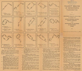
Transit routes in downtown Vancouver : side 1
Part contains illustrations of the downtown Vancouver portions of the B.C. Electric transit routes and text descriptions of all B.C. Electric transit routes in Vancouver, New Westminster, North Vancouver, Richmond, and Burnaby effective up to and including February 15, 1950.

Transit routes in downtown Vancouver : side 2
Part contains a continuation of text descriptions of transit routes from side 1. Part also contains a map showing B.C. Electric transit routing in downtown Vancouver. Map includes street names and a legend of routes and stops.