
- AM54-S4-2-: CVA 371-2274
- Item
- [193-?]
Part of Major Matthews collection
Photograph shows four men hiking
18 results with digital objects Show results with digital objects
Part of Major Matthews collection
Photograph shows four men hiking
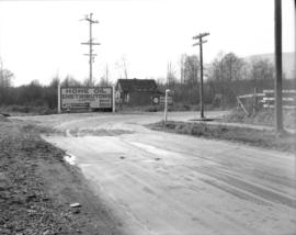
Canadian Traffic Signal Corporation - Photo of New Signals on Benwicke Avenue
Part of Stuart Thomson fonds
![[A car on the road to Grouse Mountain]](/uploads/r/null/3/c/3cecf16a6b1195008dd1f180e0badd537800a6c24e2f461a3c33844fe7d1f59b/b75e9ded-c707-4f83-b17f-30caafcba5fd-A17383_142.jpg)
[A car on the road to Grouse Mountain]
Part of Stuart Thomson fonds
Part of Major Matthews collection
Item is a topographical map of the municipalities surrounding Howe Sound and Burrard Inlet. Municipal boundaries, roads and other transportation infrastructure, and radio stations are also included. The Greater Vancouver water supply areas and waterways are shown along with pipe lines, power lines and telegraph lines.

Proposed route of Grouse Mountain Highway
Part of City of Vancouver Archives technical and cartographic drawing collection
Item is a map which shows a proposed route of Grouse Mountain Highway, including parcels of land through which it would pass. Shading indicates land owned by Hawkins & Horie. Burrard Inlet, Capilano Creek, Mosquito Creek, Lynn Creek, and Seymour Creek are also depicted.
Hawkins & Horie, Engineers & Surveyors
![[Repairing the road after the Seymour Creek washout]](/uploads/r/null/8/2/8233c5b9dc175116957eb424fa00a10f30aaf44bc9042bb1c636671f77e279fd/e9498fdf-4d04-45cc-b311-334d84b07a57-A33584_142.jpg)
[Repairing the road after the Seymour Creek washout]
Part of Major Matthews collection
![[Clearing the road after the Seymour Creek washout]](/uploads/r/null/f/c/fc6cfe672265e867d583e925ffa6c0fd3a92c7305bcba121a6f71a099afd83a8/56561df4-6b84-4fc0-b5c1-6523edbfeb84-A33580_142.jpg)
[Clearing the road after the Seymour Creek washout]
Part of Major Matthews collection
![[Clearing the road after the Seymour Creek washout]](/uploads/r/null/9/9/99242e16650f1431f325e9bb60c86ba094a887a37b72eeded67645bde3379e12/ce8d67eb-7f17-43dd-9625-f5b95c1c1b2d-A33576_142.jpg)
[Clearing the road after the Seymour Creek washout]
Part of Major Matthews collection
Photograph shows F.L. Fellowes
![[Men clearing road after Seymour creek washout]](/uploads/r/null/d/1/d1222fcec0c519f6b419c48e3cd1571b49eb57c33b1902c650ea5b73658f85f7/be9240bb-edde-4f43-a557-2bc32cbcf8c7-A33573_142.jpg)
[Men clearing road after Seymour creek washout]
Part of Major Matthews collection
![[Clearing the road after the Seymour Creek washout]](/uploads/r/null/1/e/1ebe2d6f26e96a26ae0360f58ff42655dc2845782a4d16f4c7b5cb8d33146801/4c35ed37-348f-40ff-b97f-a63d9d9360dd-A33569_142.jpg)
[Clearing the road after the Seymour Creek washout]
Part of Major Matthews collection
![[Clearing the road after the Seymour Creek washout]](/uploads/r/null/3/5/358ec572746441d60d555a7b7babb4ca18786ae34ac812377045d3a3d70e3016/6ba322a6-c3e9-4474-a5b9-944593cdf228-A33579_142.jpg)
[Clearing the road after the Seymour Creek washout]
Part of Major Matthews collection
Photograph shows F.L. Fellowes and others
![[Plank road and flume] between Sugdens and George Streets, Lynn Valley](/uploads/r/null/d/f/df03f489a5119820bf2f7e50e409932a1c4ac87aa7207a37ea12f291989561eb/698eb6d2-5a3b-4449-bdd9-6dda4b06b81a-A02705_142.jpg)
[Plank road and flume] between Sugdens and George Streets, Lynn Valley
Photograph shows road, flume, and tree stumps.
Photograph shows an elevated road and sidewalk running north under a flume. Photograph also shows houses and tree stumps.


Pipe line road, Lynn Creek, B.C.
Photograph shows muddy dirt road extending to mountain, a shack, and an elevated plank sidewalk next to the road.
![[Capilano Creek and the road leading to the old dam]](/uploads/r/null/b/e/be01881a66b0c78930e0ce748d6dde5951f2d2e3959ea751f043c90820689850/3d504293-6333-4630-898a-426f1cbe8651-A34035_142.jpg)
[Capilano Creek and the road leading to the old dam]
Part of Major Matthews collection
Photograph shows The Lions in the background

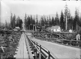
The pipe line road. Lynn Valley, B.C.
Photograph shows two men waiting for an approaching streetcar. Photograph also shows road, houses, and trees, and the mountains in the background.

Corner Pipe Line and Fromme Road, Lynn Valley, B.C.
Photograph shows intersection of two roads, and surrounding trees and stumps. Photograph also shows a signpost indicating the corner of Fromme and Lynn Valley Roads.

On the pipeline in 1909. Lynn Valley, B.C.
Photograph shows road, parallel plank sidewalk, and trees.