Map of Manitoba, Keewatin, British Columbia, and North West Territory
Map of Manitoba, Kewaydin, British Columbia and North West Territory shewing the country traversed by the Canadian Pacific Railway
Rowing crew
Threshing Manitoba Wheat Fields
Alex Godfrey with a group of men on a farm wagon, Manitoba
Mac Hamber at shooting tournament
Lake Francis Shooting Club
Eric W. Hamber standing beside ducks hanging in a row
Road map of Saskatchewan and Manitoba, highway map of southern Canada and the northern United States, and information on national parks in western Canada
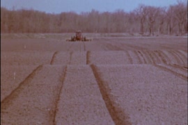
Seeding and land prep[aration]
[View of Fort Garry from across the river]
[Presbyterian church and graveyard]
[Ship in St. Andrew's Lock on the Red River north of Winnipeg]


![Seeding and land prep[aration]](/uploads/r/null/7/4/b/74b84d2200fb217006b9137a936fd3c734beb5e2d43eefbccd12d7bd62ab3a8b/3415b41c-8c68-49e7-8e54-575c37f29e53-2011-092_142.jpg)
![[View of Fort Garry from across the river]](/uploads/r/null/4/4/446b55c4b512cfee8866d2348eb4ec997e50275a388720791e5117d86bdb12b3/ce11cef1-ff04-467f-9381-39facfdfc6a4-A33470_142.jpg)
![[Presbyterian church and graveyard]](/uploads/r/null/4/7/47442b1cdc14db0667fc82b67dc27dcee7f08492c344150e9e149e02145acd49/ea3fe350-9f79-4601-b23f-af63dd15bef5-A33469_142.jpg)
![[Ship in St. Andrew's Lock on the Red River north of Winnipeg]](/uploads/r/null/5/f/5fc332226aed6f8ca4eba5711e3ffad57dbcd040892df05e2ba8ef05f07194d8/1f2be13b-855c-40fb-a27c-d17c0c0bd232-A26869_142.jpg)