
Hauling a Forest Giant in Oregon
- AM54-S4-: Tr P8.2
- Item
- [between 1940 and 1948]
Part of Major Matthews collection
117 results with digital objects Show results with digital objects
Hauling a Forest Giant in Oregon
Part of Major Matthews collection
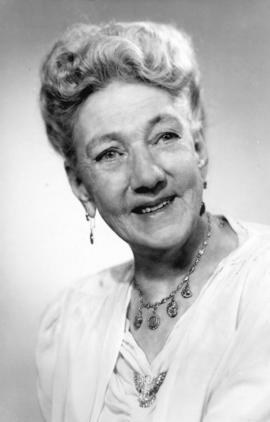
Mrs. Kate Van Duren (nee Rockwell) - "Klondike Kate"
Part of Major Matthews collection
Head and shoulders portrait
![[Mrs. Kate Van Duren (nee Rockwell) - "Klondyke Kate"]](/uploads/r/null/f/6/f6dd0ef4a7f7bd46a573ddae4b1b9a687e343a1164467831bc456c741d6473b2/6bec145e-1eb5-4299-8b4e-98b932c1faab-A35227_142.jpg)
[Mrs. Kate Van Duren (nee Rockwell) - "Klondyke Kate"]
Part of Major Matthews collection
Head and shoulders portrait

Mrs. Kate Matson (nee Rockwell) - "Klondike Kate"
Part of Major Matthews collection
Full-length studio portrait

Mrs. Kate Matson (nee Rockwell) - "Klondike Kate"
Part of Major Matthews collection
Studio portrait

Part of City of Vancouver Archives technical and cartographic drawing collection
Item is a map showing the Pacific Coast of British Columbia and Washington and Oregon states as surveyed by French explorer Jean-Francois de Galaup (Laperouse) in 1786, and the routes of his ships Astrolabe and Boussole. The map shows the Pacific coastline from Cap Rond (Tillamook Head) in Oregon at latitude 45 degrees and 40 minutes in the south to Baeie de Clonard (Beresford Bay, northwestern tip of Haida Gwaii) in British Columbia at latitude 54 degrees and 10 minutes in the north. Other major place names on the map include Nootka, Pointe Boisee, Baie St. Louis, Iles de Sartine, Mont Fleurieu, Cap Fleurieu, Cap Hector, Mont de la Touche, Baie de la Touche, and Baie de Clonard. Vancouver Island is shown as part of the mainland. Map includes latitudes and longtitudes as well as indication of elevations. Map is a plate from the "Atlas de Voyage de la Perouse".
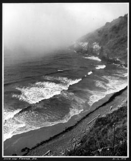
![Reef near Coos [Bay], Oregon](/uploads/r/null/a/d/b/adb2dd686ab671314fbaf4677181f33d1d3efbcd8c313900c872ea7f737d1bf4/44af7cf3-a993-4fbe-82f7-6b7105dd55de-CVA293-174_142.jpg)
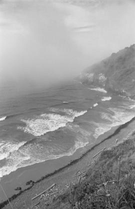
![Reef near Coos [Bay], Oregon](/uploads/r/null/b/6/8/b68fc7f39754daf649ab4f9225e3883b8f782cdac683e574ca6f46ecc45e466c/8a8afb5b-3914-4fad-960e-6433c768d182-CVA293-174_142.jpg)


Part of William Orson Banfield fonds

Part of William Orson Banfield fonds
Part of William Orson Banfield fonds

Part of William Orson Banfield fonds

Part of William Orson Banfield fonds

Part of William Orson Banfield fonds

Part of William Orson Banfield fonds

Part of William Orson Banfield fonds
Part of William Orson Banfield fonds

Part of William Orson Banfield fonds

Part of William Orson Banfield fonds

Part of William Orson Banfield fonds

The Columbia Gorge from Crown Point
Part of William Orson Banfield fonds

Part of William Orson Banfield fonds

Part of William Orson Banfield fonds

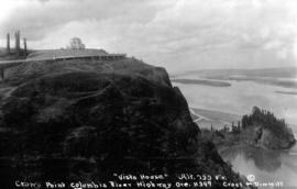
The Vista House on Crown Point
Part of William Orson Banfield fonds

Part of William Orson Banfield fonds

Part of William Orson Banfield fonds

Part of William Orson Banfield fonds

Part of William Orson Banfield fonds

Part of William Orson Banfield fonds

Part of William Orson Banfield fonds

State of Washington from Crown Point
Part of William Orson Banfield fonds

Part of William Orson Banfield fonds
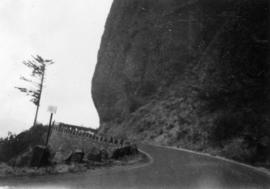
On the Columbia River Highway : The road at the base of the Bishop's Cap
Part of William Orson Banfield fonds

On the Columbia River Highway : Another tunnel, 400 feet long
Part of William Orson Banfield fonds

On the Columbia River Highway : One of the tunnels
Part of William Orson Banfield fonds

On the Columbia River Highway : Some of the highway
Part of William Orson Banfield fonds

On the Columbia River Highway : Wakeena Falls near the highway
Part of William Orson Banfield fonds

On the Columbia River Highway : The Bishops Cap
Part of William Orson Banfield fonds

On the Columbia River Highway : The Rotarian Fountain at Wakeena Falls
Part of William Orson Banfield fonds

On the Columbia River Highway : Horsetail Falls
Part of William Orson Banfield fonds
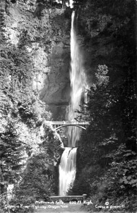
On the Columbia River Highway : Multnomah Falls, 620 feet high
Part of William Orson Banfield fonds

On the Columbia River Highway : The view from Vista House
Part of William Orson Banfield fonds

On the Columbia River Highway : Vista House
Part of William Orson Banfield fonds

On the Columbia River Highway : The motor at Vista House
Part of William Orson Banfield fonds
![On the Columbia River Highway : Myrtle [Kilpatrick] at Vista House](/uploads/r/null/f/c/2/fc2af9f0e989c71f700f275a33f6a2bae6fc621bc9fd234167dd90f8f7a4f953/27e561ed-4d40-4e5b-9a4d-eddd8fb48d52-CVA289-002_142.jpg)
On the Columbia River Highway : Myrtle [Kilpatrick] at Vista House
Part of William Orson Banfield fonds
On the Columbia River Highway : Vista House and the Columbia River
Part of William Orson Banfield fonds

Part of James Crookall fonds