
Plan of pipe lines from intake to tunnel
- COV-S371---: LEG1153.088
- Item
- Jan. 14, 1907
Part of City of Vancouver fonds
Item is a map which depicts Capilano Creek from Lot 593 to Lot 847, including pipelines and other waterworks infrastructure.
1645 results with digital objects Show results with digital objects
Plan of pipe lines from intake to tunnel
Part of City of Vancouver fonds
Item is a map which depicts Capilano Creek from Lot 593 to Lot 847, including pipelines and other waterworks infrastructure.

Capilano and Seymour water sheds
Part of City of Vancouver fonds
Item is a map which includes topography and waterworks infrastructure such as pipelines, tunnels, intakes, proposed reservoirs, etc.
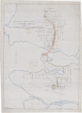
General plan of proposed extension & improvements
Part of City of Vancouver fonds
Item is a map which depicts existing and proposed new waterworks infrastructure, including the proposed new Little Mountain reservoir.
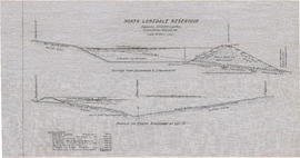
Part of City of Vancouver fonds
Item is a sheet containing an architectural drawing Section through excavation & embankment and a Profile of south boundary Lot 13. The sheet also includes an itemised list of construction cost estimates.
![Traverse of Capilano Road & pipe line through [District] Lot 594 NWD [New Westminster District]](/uploads/r/null/9/0/3/9037991f2486a9cd4c2d2940da69f422ccad131260700d83f81f8529152d8956/e01b3254-8711-47c6-a530-deb712555586-LEG1153_142.jpg)
Traverse of Capilano Road & pipe line through [District] Lot 594 NWD [New Westminster District]
Part of City of Vancouver fonds
![Plan shewing pipe line right of way through Lots 15, 16, 17, 18 & 19 D.L. [District Lot] 673 ...](/uploads/r/null/1/7/c/17c6697bdcbc4acaabcfbd2b60312b51d4b9e442fd113b9376cb994c4cdd707e/3d248d3a-3fca-431f-a491-972fea32373e-LEG1153_142.jpg)
Part of City of Vancouver fonds
![Plan of [District] Lot 792, NW [New Westminster] District B.C.](/uploads/r/null/1/9/8/198c71400d4510b6a016d3798f2512c22e9f67b50d5d1c655c276d3ad1c801ff/9801d996-d3f2-480b-86e9-8a1a5217aa41-LEG1153_142.jpg)
Plan of [District] Lot 792, NW [New Westminster] District B.C.
Part of City of Vancouver fonds
Plan of location of Capilano Road, North Vancouver
Part of City of Vancouver fonds
Item is a map depicting the Capilano River valley, from the mouth of the river at Burrard Inlet north to the dam located a District Lot 673. The map shows the route of Capilano Road and a proposed (or existing?) water pipeline route.

Wartime Housing cottages in North Vancouver
Part of City of Vancouver fonds

Part of L.D. Taylor family fonds
Photograph shows three men in a scow navigating rapids in the Seymour Gorge.

Part of L.D. Taylor family fonds
Photograph shows three small boats tied along the river bank and two men rowing a canoe in the river.

Part of Karl Koenig fonds

Erickson Cutter, Geo. Bone's Yard at Mosquito Creek
Part of Karl Koenig fonds
Item is a photograph showing the boat, Erickson Cutter, at Geo. Bone's Yard at Mosquito Creek.

Part of Karl Koenig fonds
Item is a photograph showing the boat, Erickson Cutter, at a fish cannery.

People with dog on beach at Mosquito Creek
Part of Karl Koenig fonds

Part of City of Vancouver Archives sound recording and moving image collection
Film is a travelogue showcasing scenery, attractions and industry in the Vancouver area. Film contains general and aerial views of Vancouver, plus sequences of the harbour, Vancouver International Airport, Stanley Park, UBC, the Vancouver International Festival and the PNE. Industry is depicted through shots of a sawmill, a fish cannery, a foundry and a shipyard (where the vessel Yukon is launched). Water sports, golf and skiing at Grouse Mountain are shown, as well as Queen Elizabeth Park, Capilano Suspension Bridge, the Queen Elizabeth Theatre, Granville Street at night and a White Spot drive-in. Individuals involved with the production of the film include: Jim Richardson (script), David Bennett (director), A.J.H. Pullinger (cinematography), Norma Jackson (editing), Lloyd Stump (sound), Saba Bros. Limited (gowns), Marguerite Roozeboom (art direction), recorded by Telesound, Lew Perry (producer).
![Seens [scenes] of Van[couver], Capilano, Stanley Park](/uploads/r/null/1/3/b/13bc9013786c37378f12ed8a438df461807fab1a389b9e9c2896f171e1c9e03f/b640bf28-47ef-404b-9944-eeb4bd5eeda9-2012-033_142.jpg)
Seens [scenes] of Van[couver], Capilano, Stanley Park
Part of City of Vancouver Archives sound recording and moving image collection
Item is a film showing various scenes around Vancouver. The first half of this film documents a Gray Line Tours bus trip through Vancouver and second half contains scenes showing landmarks of Vancouver and surrounding areas. Film contains footage showing: Empress of Japan Figurehead in Stanley Park, U.B.C., Chinatown, Hotel Georgia, Lion's Gate Bridge, Court House, Capilano Suspension Bridge, Capilano Golf and Country Club, Prospect Point, Stanley Park, views of downtown and North Shore Mountains from Little Mountain, City Hall, sailboats in Burrard Inlet, and Swimmers at Kits Beach.


Capilano River and Suspension Bridge
Item includes directions and rates for Seymour Mountain Chairlift.
Seymour : existing traffic and services
The natural environment of the Maplewood Estuaries
Item outlines the effects of development and planning implications for the ecology of the region.

Map of portion New Westminster District
Part of City of Vancouver Archives technical and cartographic drawing collection
Item is a heavily-amended copy of a map illustrating intended land settlement and subdivision in 1877 in the future sites of Vancouver, Burnaby and the North Shore, from an area bordering on English Bay to an area bordering on North Arm. Also shown are bodies of water, Hastings & Granville Road, and the settlements of Hastings and Granville. Annotations by J.S. Matthews in 1954 made on the copy are tracings in white pen and darkening the background to improve the copy.

Street index (Royal Oak Avenue, Vancouver to Frederick Road, North Vancouver)
Part of City of Vancouver Archives technical and cartographic drawing collection
Part contains two pages from the booklet accompanying a guide map of Greater Vancouver. Pages include the last portion of the Vancouver and Burnaby street index, the New Westminster street index, and the North Vancouver street index from 1st Street to Frederick Road.

Vancouver North. British Columbia
Part of City of Vancouver Archives technical and cartographic drawing collection
Item is a topographical map showing the eastern portion of Sechelt Peninsula, Keats Island, southern portion of Gambier Island, Bowen Island, West Vancouver, North Vancouver, and Vancouver. City streets and blocks are shown, as well as surveyed parcels of land. Map also shows depth contours in fathoms for Howe Sound and Burrard Inlet.
Let's go see! Inside Vancouver
Part of City of Vancouver Archives technical and cartographic drawing collection
Item is a tourist brochure featuring information on attractions on the North Shore (North Vancouver and West Vancouver) and maps showing routes to the area.

Plan of the townsite of North Vancouver
Part of City of Vancouver Archives technical and cartographic drawing collection
item is a map showing lots and land subdivision in North Vancouver, most likely related to real estate sales. Index map shows the location of North Vancouver relative to Greater Vancouver.

City and District of North Vancouver
Part of City of Vancouver Archives technical and cartographic drawing collection
Item is a map showing the city and district of North Vancouver. It shows paved roads, gravel roads, unopened roads and a graphical depiction of the population as of 1947. A small inset map shows the position of the city of North Vancouver and the district of North Vancouver in relation to Vancouver, Burrard Inlet and West Vancouver. Annotations appear to be in J.S. Matthews' hand, noting a portion of North Vancouver as "King's Lynn".
Part of City of Vancouver Archives technical and cartographic drawing collection
Item is a street map showing Vancouver, Burnaby, New Westminster, West Vancouver, and North Vancouver on one side and the Lower Mainland from Vancouver to Chilliwack on the other. Item includes lists of businesses, schools, public buildings, hospitals, bathing beaches, fire halls, and golf and country clubs, as well as text advertising the products and services of the Dominion Map and Blueprint Company.
![Plate 163 [Key Plan of North Vancouver]](/uploads/r/null/e/1/d/e1d59c4aba0a20f0522dd57d1ecfbcc6fa0e15d2cb581616d819932b7b4485b7/be98b40c-82d0-4d47-97d2-e5bc54e3e904-1974-100_142.jpg)
Plate 163 [Key Plan of North Vancouver]
Part of City of Vancouver Archives technical and cartographic drawing collection
![Plate 164 [Lonsdale Avenue to Second Street to Chesterfield Avenue to Burrard Inlet]](/uploads/r/null/b/c/5/bc5801cb1cab9f718c08d5e85247acf3c6c6d41621bd633be9636327b722a9cd/db55d2fa-bc36-4407-a98b-9c062774aa12-1974-100_142.jpg)
Plate 164 [Lonsdale Avenue to Second Street to Chesterfield Avenue to Burrard Inlet]
Part of City of Vancouver Archives technical and cartographic drawing collection

Beverage Dispensers Union (Locals 676 and 835) Picnic Swedish Park
Part of Hotel, Restaurant and Culinary Employees and Bartenders Union, Local 40 fonds
Panoramic view group portrait showing the "Lind Bowl"
![[Mrs. Vern Kendrick placing her child in a crib]](/uploads/r/null/8/0/805397e73b6fa6e0f74a9947b1a802777e6cc890e621392dd59f197394b68572/e8ff41cc-038b-4c2f-b007-f4928473fdb8-A10477_142.jpg)
[Mrs. Vern Kendrick placing her child in a crib]
Photograph shows part of a bedroom interior of a home in the shipyard housing program.
![[Nurses bandaging patients at an A.R.P. display]](/uploads/r/null/a/c/ac377608826b70ee01c5138ee7495ef626c9aad186f2acf67b845e8e1b2363dc/0555e25f-dd40-4c6f-998c-aeac6dbcea72-A10656_142.jpg)
[Nurses bandaging patients at an A.R.P. display]
![[Man taking a putt shot on the Capilano Golf Course]](/uploads/r/null/4/e/4e4ab44af78a120c440c2f451aa9d241155528554ae10eebafdf6f3fa97f0eb4/b97fad9c-2aee-4605-968d-5269b3bdb891-A13438_142.jpg)
[Man taking a putt shot on the Capilano Golf Course]

Part of James Crookall fonds

Part of James Crookall fonds

View of the Lions taken from Grouse Mountain
Part of James Crookall fonds

Part of James Crookall fonds

Seymour Creek taken fron Siwash pool
Part of James Crookall fonds
![Panorama from Grouse [Mountain]](/uploads/r/null/c/5/1/c51c62e8be025b40b3bfcde7713db4eed0aca3e08d716e5d3172a6dd05833f9e/14476f38-2412-4388-bbfa-9bc81dc58ddd-CVA260-1629_142.jpg)
Panorama from Grouse [Mountain]
Part of James Crookall fonds

Part of James Crookall fonds
![James Crookall near shack [near] Capilano](/uploads/r/null/9/8/6/986c4f0181cb97f0fb06f7ac57b073d69e6df7247eaf6ca9a4a92a56ab0b98e8/db84c6e0-156e-4328-b535-1ba402cb96bc-CVA260-1675_142.jpg)
James Crookall near shack [near] Capilano
Part of James Crookall fonds

Part of James Crookall fonds

Part of James Crookall fonds
![[View of The Lions]](/uploads/r/null/3/3/0/330b2188d906060b5c08806c750518ab72b962497e7843fde04e672d696ce0a5/1f2432ed-0880-4ad5-90f5-ed624b735724-CVA260-1132_142.jpg)
Part of James Crookall fonds
![[View from the water of a dock engulfed in fire]](/uploads/r/null/a/0/2/a029dc2a685665c18c3e35a76b80fc0608863401a6afac3ec0148cd6fb65c020/a496e9d2-4067-4f9f-90c0-cce562469b2f-CVA260-1116_142.jpg)
[View from the water of a dock engulfed in fire]
Part of James Crookall fonds