![[Aerial view of portion of Bowen Island]](/uploads/r/null/1/1/112d6af85f045f49c54e8786e4dffa7ccb267bb885799bdfd9ad660b8cc5ef1f/a1de2ed6-0c5f-4f64-95c5-45d525e4b142-A31872_142.jpg)
[Aerial view of portion of Bowen Island]
![[Aerial view of] Gibsons, Grathams and Hopkins Landing](/uploads/r/null/b/6/b6a6b41d780717a3dc8cd38abb1ef493c90fd4e2aec834178d3dbb3990984c1d/4aff2f25-a117-49e3-bcb5-344ae0db5621-A23484_142.jpg)
[Aerial view of] Gibsons, Grathams and Hopkins Landing
![[Aerial view of] Pacific National Exhibition [at Hastings Park]](/uploads/r/null/a/c/acd5dd5e58cdbe8cd9c6468f795b4a633b0c3ea659353323eba7ec40221ad776/aa746b47-2f03-4577-94ef-977cab2a0066-A23456_142.jpg)
[Aerial view of] Pacific National Exhibition [at Hastings Park]

Composite Aerial Mosaic of Metropolitan Vancouver Compiled from 50 Individual Photographs Taken in 1952 from Altitude of 20,000 feet
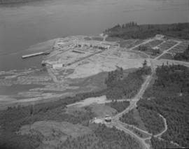
Elk Falls Co. : Campbell River aerials
Elk Falls Co. : Campbell River aerials
Elk Falls Co. : Campbell River aerials

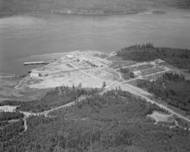
Aerials : Elk Falls Mill : Duncan Bay

Aerials : Elk Falls Mill : Duncan Bay

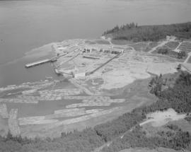
Aerials : Elk Falls Plant

Cape Mudge Lighthouse from the Air
![[Aerial survey photograph]](/uploads/r/null/f/a/fab195a7fc233deb2d6de7cd7adbb1c17e581561907ad4326ec3e70802b8053e/7186442f-d249-4e5f-9aca-ac698f0376fd-A40953_142.jpg)
[Aerial survey photograph]
![[Aerial survey photograph]](/uploads/r/null/5/d/5d61d720b2a88dce52e09ab49a7ef4942b0eac1405c7b4e765e3beda6f25999a/b0d55cc5-84f3-47e9-919c-a036db614315-A48057_142.jpg)
[Aerial survey photograph]
![[Aerial view looking north over] Granville Island](/uploads/r/null/8/3/83f9be0a597100103c181fa4d68c68baa4a0802471126afafea3b7850103e12b/ea9e7fb6-7465-4fa6-8fa9-18923e3d9307-A49646_142.jpg)
[Aerial view looking north over] Granville Island

Aerial photo, oblique, CPR docks in foreground, looking south Granville Street at centre
![[Aerial view looking east of downtown Vancouver and the waterfront]](/uploads/r/null/a/1/a146c28159c45997dd3312d8a94967907da12e5b5c1139902f95665ab0e54675/740905a3-6e61-4ffc-bc08-d90ad82bc7d8-A67011_142.jpg)
[Aerial view looking east of downtown Vancouver and the waterfront]

Prince George, British Columbia

Aerial view of P.N.E. Gayway at night

Aerial view of P.N.E. Gayway at night
![[Aerial view of Vancouver]](/uploads/r/null/a/e/aea3d75fc7ebb88b78ad9efab62904bc9667abedf965cfd73ee6efd909a5e01b/ec4fb3c6-e62c-4383-b7f4-a31a2c2c00d1-A23515_142.jpg)
[Aerial view of Vancouver]
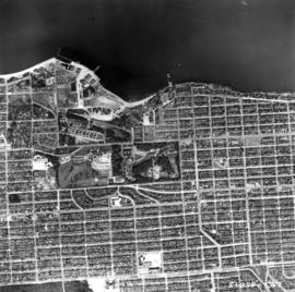
![[Aerial view showing the northwestern section of Downtown]](/uploads/r/null/d/a/da84098b0ef036990e34132f726d1491bbbb1fc247cc76fc6659886372017fdc/a8601693-c900-4d47-a380-9979b203400b-A43287_142.jpg)
[Aerial view showing the northwestern section of Downtown]

Aerial view of P.N.E. Gayway at night

Annacis Island

British properties
![[Job no. 787 : Aerial view of Lethbridge Municipal Hospital construction site]](/uploads/r/null/f/5/f59c10c9e3f8ec1ff0c5c68da446a51a650545283db9bdc49d5c33723b1024c3/7cdc21ca-f296-4f68-aa78-7be1900f2da1-A38075_142.jpg)
[Job no. 787 : Aerial view of Lethbridge Municipal Hospital construction site]
![[Job no. 787 : Aerial view of Lethbridge Municipal Hospital construction site]](/uploads/r/null/c/d/cd4a6be61148d220d62516b4f709a7a93551576483890f0ec0af40505049f753/2d418993-dc89-46d1-b654-06c20676222e-A38076_142.jpg)
[Job no. 787 : Aerial view of Lethbridge Municipal Hospital construction site]
![[Aerial view of Kitsilano looking east over Kitsilano Beach]](/uploads/r/null/d/e/de9aa8187efba90164a4908026214320fff2d9978653d3f44f938fe4d88186b9/58cc6c82-2e2f-4948-9fa1-ba29c7edbea5-A23480_142.jpg)
[Aerial view of Kitsilano looking east over Kitsilano Beach]
![[Aerial view looking west over Granville Island]](/uploads/r/null/d/5/d5e5021eedf545a1ee16153e245643d67a63469ee5d43b1eeee58dd438678103/8fac530f-b053-43dc-9ffa-94995fd358d1-A49645_142.jpg)
[Aerial view looking west over Granville Island]

Stanley Park from the air
2nd Narrows Bridge under Construction
![[Aerial view Downtown Vancouver and Coal Harbour]](/uploads/r/null/8/c/8c93e516088c33802463e3cade7f8669bd70f2cafc2ae8e069b9588009337ffd/9cb6889d-8bc1-456b-8780-3a3bc50d7baf-A23514_142.jpg)
[Aerial view Downtown Vancouver and Coal Harbour]
![[Aerial view of Vancouver looking east]](/uploads/r/null/9/3/93309104da24ef0ea4391055c01c783c88d8d52c9939ee604b894d907555df68/564df6c6-3fbe-40b9-bba9-6386ae62ff3c-A23479_142.jpg)
[Aerial view of Vancouver looking east]
![[Aerial view of Vancouver looking northeast]](/uploads/r/null/e/b/eb04990a1e0714b74de255da43c9b8ae6f6f52e23bbf3735f707b20d0463fbe0/b9785bd2-0b41-4ed0-9f20-b5faf38aaf2f-A23478_142.jpg)
[Aerial view of Vancouver looking northeast]

Aerial view of the downtown core, post office under construction
![[Aerial view of Evergreen Park Resort]](/uploads/r/null/9/d/b/9dbe08a7883091f0c43b98eebc02ef89b97cfdf03ccc32b018ce207bfc741457/c0e7fd04-3256-42c8-9328-0869e3731928-CVA374-319_142.jpg)
[Aerial view of Evergreen Park Resort]
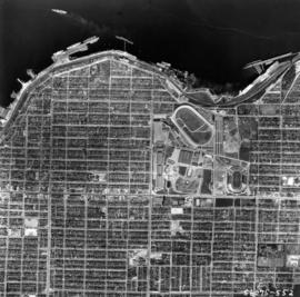
![[Aerial survey view of First Narrows, Stanley Park, the West End, Downtown and North Vancouver]](/uploads/r/null/f/8/f875c0a639388b4936ef86faafb227a0fcad6478409cc8c2ff64fa2c06296ca5/94a6f99f-1ce3-4c9b-9e48-894735d096e9-A23486_142.jpg)
[Aerial survey view of First Narrows, Stanley Park, the West End, Downtown and North Vancouver]
![[Aerial view of] British Pacific Properties [and North Vancouver]](/uploads/r/null/1/4/14644a75d43dd6a85d7a3c082e63134f4994ac268e97d1c0940f786b344bbd7e/46041e12-d683-4b08-81b0-797947030f8f-A23485_142.jpg)
[Aerial view of] British Pacific Properties [and North Vancouver]
![[Aerial photograph of downtown Vancouver looking north]](/uploads/r/null/2/4/24032a0f19bc217e5bb533d7218824f932301e972f1020a352118b50afcf8a93/8e2450db-6794-4283-95a6-7641bc80437d-A69847_142.jpg)
[Aerial photograph of downtown Vancouver looking north]
![[Aerial view of Evergreen Park Resort]](/uploads/r/null/2/4/4/244557fcfccb2526a22199fee0e714fd6116fc056c2fac4473e1e31cc0dfa124/57fc44e3-e476-42d8-b7f6-7b2cd5bbe3fb-CVA374-318_142.jpg)
[Aerial view of Evergreen Park Resort]
Aerial photo, vertical, Jericho Beach Park and Kitsilano

Aerial photo, vertical, False Creek, Fairview to Kits Point

Aerial photo, vertical, Iona Island and Fraser River

Aerial photo, vertical, University of British Columbia and University Endowment Lands

Aerial photo, vertical, Marpole and junction of Fraser River, Bridgeport

Aerial photo, vertical, Little Mountain and Oakridge and surrounding area
Aerial photo, vertical, Exhibition Park and surrounding area
Vancouver Airport & Admin buildings

1957 Aerial photos of BC Sugar

North Arm of Fraser River

University of British Columbia and Norman Mackenzie House