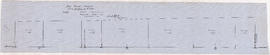
![Sheet 9B [Slocan Street to 6th Avenue to Semlin Drive to 14th Avenue]](/uploads/r/null/b/7/5/b75c61b603e8ab998f68941a380457aeae4de4affd845d40405472b07f3738a2/140ef05a-e687-4959-a97a-2765c7610a3c-LEG1153_142.jpg)
Sheet 9B [Slocan Street to 6th Avenue to Semlin Drive to 14th Avenue]
- PUB-: PD 2135-: LEG1153.167
- Part
- [ca. 1955] (copied ca. 1980)
Part of City publications collection
264 results with digital objects Show results with digital objects
Sheet 9B [Slocan Street to 6th Avenue to Semlin Drive to 14th Avenue]
Part of City publications collection
![Sheet 9C [Hull Street/Semlin Drive to 14th Avenue to Clark Drive to 22nd Avenue]](/uploads/r/null/b/4/8/b48f272549a65e8622204f5c1a677afad16a9ef19306e9696b31ef6d9c08cf16/c56229a4-c4b1-492d-b215-b5b53f060d69-LEG1153_142.jpg)
Sheet 9C [Hull Street/Semlin Drive to 14th Avenue to Clark Drive to 22nd Avenue]
Part of City publications collection
![Sheet 9D [Slocan Street to Grandview Highway to Marshall Street to 22nd Avenue]](/uploads/r/null/b/1/c/b1c4c0bbf98c9c2ff5a2e60e8350582f0e591688b2f9670ba1f4aaecc638b227/7e2aefcc-f31d-4c11-a0ae-1293bd850528-LEG1153_142.jpg)
Sheet 9D [Slocan Street to Grandview Highway to Marshall Street to 22nd Avenue]
Part of City publications collection
Soo River profile from 6+3820 to 9+2380
Part of City of Vancouver fonds

Soo River profile from 9+2380 to 15+1650
Part of City of Vancouver fonds

Soo River profile from Green River junction west 6 miles 3820 ft
Part of City of Vancouver fonds
Item is a map showing a surveyor's traverse of the perimeter of Brockton Point and interior roads.
Vancouver Park Board
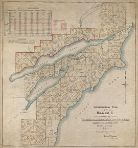
Topographical map of Block 1 containing T.L.s 8043-4-5, 8048, 8054-5-6-8-9 & 8086
Part of Eustace Smith Ltd. fonds

Topographical map of Garibaldi Park
Part of City of Vancouver fonds
Item is a copy of a Government of British Columbia Lands Department map which has been used as a base map to depict elements of the proposed development. Annotations depict routes of pipleines and tunnels; locations of powerhouses, dams and shafts; and acreages of affected areas.
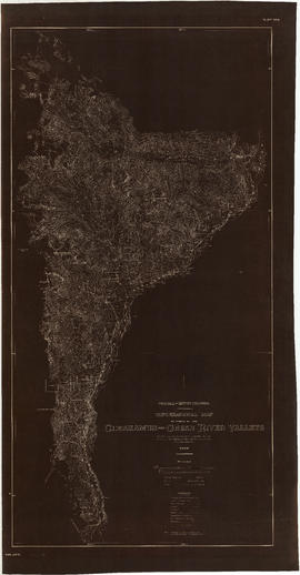
Topographical map of parts of the Cheakamus and Green River valleys
Part of City of Vancouver fonds

Topographical map of parts of the Cheakamus and Green River Valleys
Part of City of Vancouver fonds
Item is a copy of a Government of British Columbia Lands Department map which has been used as a base map to depict elements of the proposed development. Annotations depict acreages of affected areas.
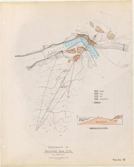
Topography of proposed dam site
Part of City of Vancouver fonds
Item is a sheet with two maps depicting a possible dam site on the Cheakamus River: a topographical map of the site with the dam location annotated, and a cross-section depicting the geology of the dam site.
Part of Major Matthews collection
Item consists of a tracing of two maps on one sheet, of a map most likely originally drawn in 1859 or 1860. Based on the copied annotations, this tracing appears to be at least a second (or possibly third) generation tracing from the original map created as a result of the H.M.S. Plumper surveys of the area at that time.
One map shows Burrard Inlet, Point Grey, Spanish Bank [sic], Point Atkinson, English Bay, Downtown Peninsula, Coal Peninsula, Brockton Point, First Narrows and False Creek, and proposed government land reserves in these areas. The second map shows Burrard Inlet and Port Moody and proposed government land reserves in this area.
Part of City of Vancouver fonds
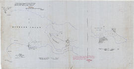
Item is a map sheet containing two maps. The main map shows the topography of the upper Lillooet River. The secondary map is a key map showing the entire Lillooet River system.