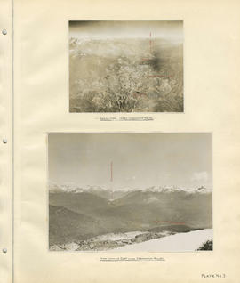
Aerial view - Lower Cheakamus Region and View looking east across Cheakamus Valley
- COV-S40-MAP 939-: LEG1153.036
- Item
- [1931]
Part of City of Vancouver fonds
Aerial view - Lower Cheakamus Region and View looking east across Cheakamus Valley
Part of City of Vancouver fonds
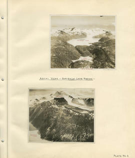
Aerial views - Garibaldi Lake region
Part of City of Vancouver fonds
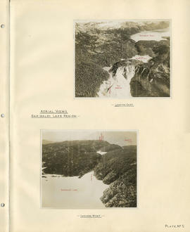
Aerial views - Garibaldi Lake region
Part of City of Vancouver fonds

Part of City of Vancouver Archives technical and cartographic drawing collection

Burrard Inlet - Dollarton sheet
Part of City of Vancouver Archives technical and cartographic drawing collection

Burrard Inlet - Port Moody sheet
Part of City of Vancouver Archives technical and cartographic drawing collection

Burrard Inlet - Second Narrows sheet
Part of City of Vancouver Archives technical and cartographic drawing collection

Burrard Inlet - triangulation control
Part of City of Vancouver Archives technical and cartographic drawing collection

Burrard Inlet - Vancouver sheet
Part of City of Vancouver Archives technical and cartographic drawing collection

Part of Major Matthews collection
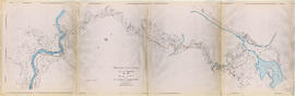
Item is a copy of a portion of a manuscript map of Burrard Inlet, created during the H.M.S. Plumper survey of the area. Sheet shows the eastern portion of the Inlet, including the southern portion of the North Arm.
United Kingdom. Admiralty

Part of City of Vancouver Archives technical and cartographic drawing collection
Map shows a survey conducted by the Canadian Pacific Railway of English Bay, Burrard Inlet and Coal Harbour, including a rough outline of area and lots. Note on map reads "Certified as a correct plan showing the land required for right of way Burrard Inlet B.C., February 22, 1886. H.J. Cambie, Engineer in Charge." Map is certified as correct and signed by various C.P.R. officials, including W.C. Van Horne.

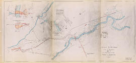
Cheakamus power survey for City of Vancouver 1930-1931. General plan and profile
Part of City of Vancouver fonds
Item is a map depicting south-western British Columbia and noting the location of the area covered by the plates in the atlas. The sheet also includes a profile of the survey area from Cheakamus Lake to Garibaldi Lake.

Part of City of Vancouver fonds
Item is a group of charts depicting flows by month measured at various points along the Cheakamus River.

Part of City of Vancouver fonds
Item is a sheet depicting a topographical map of the planned development from Garibaldi Lake to Daisy Lake. The sheet also includes a profile along the proposed tunnel and pipeline route.

Part of City of Vancouver fonds
Item is a topographic map of Cheakamus Lake, showing elements of the proposed power infrastructure. The map also includes an inset topographic map of the proposed dam site and a capacity diagram of Cheakamus Lake.
Part of City of Vancouver fonds
Item is a map sheet containing three topographical maps, depicting the Cheakamus River and Brandywine Creek, the dam site at Brandywine Creek ,and the proposed dam site near McGuire. The sheet also includes sectional drawing of the McGuire dam site, as well as charts of pondage at McGuire and Brandywine.

Part of City of Vancouver fonds

Part of City of Vancouver fonds

Part of City of Vancouver fonds

Cheakamus power survey for City of Vancouver 1930-1931. Proposed storage reservoir at Daisy Lake
Part of City of Vancouver fonds
Item is a map sheet containing two maps depicting portions of the Cheakamus River at or near Daisy Lake, with proposed power infrastructure. The sheet also contains charts depicting a capacity diagram for Daisy lake reservoir and cross-sections at Dyke #1 and Dyke #2.
Part of City of Vancouver fonds
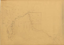
Cheakamus River. Brandywine Creek to Cheakamus Lake
Part of City of Vancouver fonds
Item is a rough preliminary sketch map of part of the Cheakamus River. The map includes notes on terrain, survey data points, the PGE railway right of way, and District Lots.

Cheakamus River valley with possible dam location
Part of City of Vancouver fonds
Item is a sheet with three maps depicting a possible dam site on the Cheakamus River: a topographical map of the site with the dam location annotated, a cross-section depicting the geology of the dam site, and a profile of the tentative location of a tunnel.

Cheakamus River with proposed dam site at McGuire
Part of City of Vancouver fonds
Item is a sheet with three maps depicting a possible dam site on the Cheakamus River near McGuire: a topographical map of the site with the dam location annotated, and a cross-section depicting the geology of the dam site.

Chilliwack Lake scheme & Jones Lake scheme
Part of City of Vancouver fonds
Item is a map depicting proposed hydro-electric development north-west of Chilliwack Lake. The map shows the location so proposed dams, flumes, tunnels and the location of a power house on the Fraser River west of Jones Lake.

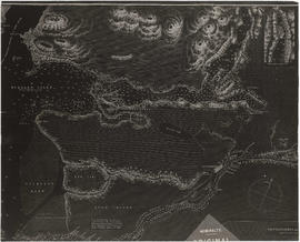
Contour map shewing proposed location of flume, reservoir and power plant Cheakamus River, B.C.
Part of City of Vancouver fonds
Item is a copy of a map that appears to have been created as part of power development proposal by DuCane, Dutcher & Co. The map was likely acquired by the City Engineer's Office as a reference map for surveying work done in the Cheakamus River area in 1923.

Contours in Chilliwack Valley near Chipmunk Run
Part of City of Vancouver fonds

Part of City of Vancouver fonds
Item is a map sheet containing two profiles: one showing the increased reservoir height with a subsidiary dam built and the other a profile of the proposed subsidiary dam site.

Fraser River - Annacis Island sheet
Part of City of Vancouver Archives technical and cartographic drawing collection

Fraser River - Deas Island sheet
Part of City of Vancouver Archives technical and cartographic drawing collection

Part of City of Vancouver Archives technical and cartographic drawing collection

Fraser River - New Westminster sheet
Part of City of Vancouver Archives technical and cartographic drawing collection

Fraser River - Port Mann sheet
Part of City of Vancouver Archives technical and cartographic drawing collection

Fraser River - Sand heads sheet
Part of City of Vancouver Archives technical and cartographic drawing collection

Fraser River - Steveston sheet
Part of City of Vancouver Archives technical and cartographic drawing collection

Fraser River - Tilbury Island sheet
Part of City of Vancouver Archives technical and cartographic drawing collection

Fraser River - triangulation control
Part of City of Vancouver Archives technical and cartographic drawing collection

Fraser River and Burrard Inlet
Part of Major Matthews collection
Fraser River and Burrard Inlet
Part of Major Matthews collection

Fraser River and Burrard Inlet
Part of Major Matthews collection

Garibaldi Lake study 1932-1933
Part of City of Vancouver fonds
Item is a graph depicting gauge water heights for Lesser Garibaldi Lake, Garibaldi Lake, Upper Rubble Creek, Lower Rubble Creek for the period Apr. 1932 to Apr. 1933.

Garibaldi Lake, Daisy Lake and Cheakamus River
Part of City of Vancouver fonds
Item is a sheet containing the following survey photographs: Stillwater below Daisy Lake; Looking up Cheakamus River from canyon dam site; Leakage from Garibaldi Lake through lava into Garibaldi Creek; Looking up-stream from near Cheakamus Canyon power station; Looking up Cheakamus River from P.G.E. Rlwy. bridge Mile 19.1; Looking up Cheakamus River to Daisy Lake dam site; Looking down Cheakamus river from canyon dam site.

General plan of proposed development of Alouette water power
Part of City of Vancouver fonds

Part of City of Vancouver fonds
Item is an architectural drawing sheet depicting a plan and section of the intake on the Bridge River, and the power house on Seton Lake.

General plan of works to be constructed at Nairn Falls. Green Lake. Lillooet District, B.C.
Part of City of Vancouver fonds
Item is a topographical map showing the location of proposed power house, dam and other hydro-electric infrastructure at the north end of Green Lake, tunnel, and the Pacific Great Eastern Railway right-of-way along the northern edge of Green Lake.

Head of Callaghan Creek and Lower Callaghan Lake
Part of City of Vancouver fonds

Hydro electric survey. Cheakamus River from Squamish River to Brandywine Creek
Part of City of Vancouver fonds

Junction of Cheakamus and Squamish Rivers and Cheakamus Canyon
Part of City of Vancouver fonds
![Longitudinal section along [centre line] of dam sites at north end of Green Lake](/uploads/r/null/7/4/a/74af74789da62d7da66c012dd18dd964e4e83151ac5f0b139a53843bce6ccfe6/974ff05f-0f29-4e65-b818-c663b1a236e1-MAP1142_142.jpg)
Longitudinal section along [centre line] of dam sites at north end of Green Lake
Part of City of Vancouver fonds
Item is a sheet depicting 2 profiles: one of dam no. 1 at railway crossing at 2247+763 and one of dam no. 2 at the head of the Green River (Green Lake).